欧洲泥炭地湿度条件的最新趋势

IF 3.8 Q2 ENVIRONMENTAL SCIENCES
Laura Giese , Maiken Baumberger , Marvin Ludwig , Henning Schneidereit , Emilio Sánchez , Bjorn J.M. Robroek , Mariusz Lamentowicz , Jan R.K. Lehmann , Norbert Hölzel , Klaus-Holger Knorr , Hanna Meyer
{"title":"欧洲泥炭地湿度条件的最新趋势","authors":"Laura Giese ,&nbsp;Maiken Baumberger ,&nbsp;Marvin Ludwig ,&nbsp;Henning Schneidereit ,&nbsp;Emilio Sánchez ,&nbsp;Bjorn J.M. Robroek ,&nbsp;Mariusz Lamentowicz ,&nbsp;Jan R.K. Lehmann ,&nbsp;Norbert Hölzel ,&nbsp;Klaus-Holger Knorr ,&nbsp;Hanna Meyer","doi":"10.1016/j.rsase.2024.101385","DOIUrl":null,"url":null,"abstract":"<div><div>Peatlands play a key role in climate change mitigation strategies and provide multiple ecosystem services, presuming near natural, waterlogged conditions. However, there is a lack of knowledge on how spatially heterogeneous changes in climate across Europe, such as the predicted increase in drought frequency in Central Europe, might affect these ecosystem services and peatland functioning. While analysis of peat cores and moisture sensors provide high-quality insights into past or present hydrological conditions, this information is usually only available for a limited number of locations. Satellite remote sensing is an effective method to overcome this limitation, providing spatially continuous and temporally highly resolved environmental information.</div><div>This study proposes to use freely available data from the Landsat Mission to analyze trends in proxies of surface moisture of European peatlands over the last four decades. Based on a large random sample of peatland sites across Europe, we performed a pixel-wise trend analysis on monthly time-series dating back to 1984 using the Normalized Difference Water Index as a moisture indicator.</div><div>The satellite-derived moisture changes indicated a pronounced shift towards wetter conditions in the boreal and oceanic region of Europe, whereas in the temperate, continental region, a high proportion of peatlands experienced drying. Small-scale patterns of selected sites revealed a high spatial heterogeneity, the complexity of hydro-ecological interactions, and locally important environmental and anthropogenic drivers affecting the moisture signal. Overall, our results support the expected effects of current climate trends of increasing precipitation in boreal northern and oceanic north-western Europe and increasing frequency of drought in continental Europe.</div><div>Our fully reproducible approach provided new insights on continental and local scales, relevant not only to a better understanding of moisture trends in general, but also to practitioners and stakeholders in ecosystem management. It may thus contribute to developing a cost-effective long-term monitoring strategy for European peatlands.</div></div>","PeriodicalId":53227,"journal":{"name":"Remote Sensing Applications-Society and Environment","volume":"37 ","pages":"Article 101385"},"PeriodicalIF":3.8000,"publicationDate":"2024-10-30","publicationTypes":"Journal Article","fieldsOfStudy":null,"isOpenAccess":false,"openAccessPdf":"","citationCount":"0","resultStr":"{\"title\":\"Recent trends in moisture conditions across European peatlands\",\"authors\":\"Laura Giese ,&nbsp;Maiken Baumberger ,&nbsp;Marvin Ludwig ,&nbsp;Henning Schneidereit ,&nbsp;Emilio Sánchez ,&nbsp;Bjorn J.M. Robroek ,&nbsp;Mariusz Lamentowicz ,&nbsp;Jan R.K. Lehmann ,&nbsp;Norbert Hölzel ,&nbsp;Klaus-Holger Knorr ,&nbsp;Hanna Meyer\",\"doi\":\"10.1016/j.rsase.2024.101385\",\"DOIUrl\":null,\"url\":null,\"abstract\":\"<div><div>Peatlands play a key role in climate change mitigation strategies and provide multiple ecosystem services, presuming near natural, waterlogged conditions. However, there is a lack of knowledge on how spatially heterogeneous changes in climate across Europe, such as the predicted increase in drought frequency in Central Europe, might affect these ecosystem services and peatland functioning. While analysis of peat cores and moisture sensors provide high-quality insights into past or present hydrological conditions, this information is usually only available for a limited number of locations. Satellite remote sensing is an effective method to overcome this limitation, providing spatially continuous and temporally highly resolved environmental information.</div><div>This study proposes to use freely available data from the Landsat Mission to analyze trends in proxies of surface moisture of European peatlands over the last four decades. Based on a large random sample of peatland sites across Europe, we performed a pixel-wise trend analysis on monthly time-series dating back to 1984 using the Normalized Difference Water Index as a moisture indicator.</div><div>The satellite-derived moisture changes indicated a pronounced shift towards wetter conditions in the boreal and oceanic region of Europe, whereas in the temperate, continental region, a high proportion of peatlands experienced drying. Small-scale patterns of selected sites revealed a high spatial heterogeneity, the complexity of hydro-ecological interactions, and locally important environmental and anthropogenic drivers affecting the moisture signal. Overall, our results support the expected effects of current climate trends of increasing precipitation in boreal northern and oceanic north-western Europe and increasing frequency of drought in continental Europe.</div><div>Our fully reproducible approach provided new insights on continental and local scales, relevant not only to a better understanding of moisture trends in general, but also to practitioners and stakeholders in ecosystem management. It may thus contribute to developing a cost-effective long-term monitoring strategy for European peatlands.</div></div>\",\"PeriodicalId\":53227,\"journal\":{\"name\":\"Remote Sensing Applications-Society and Environment\",\"volume\":\"37 \",\"pages\":\"Article 101385\"},\"PeriodicalIF\":3.8000,\"publicationDate\":\"2024-10-30\",\"publicationTypes\":\"Journal Article\",\"fieldsOfStudy\":null,\"isOpenAccess\":false,\"openAccessPdf\":\"\",\"citationCount\":\"0\",\"resultStr\":null,\"platform\":\"Semanticscholar\",\"paperid\":null,\"PeriodicalName\":\"Remote Sensing Applications-Society and Environment\",\"FirstCategoryId\":\"1085\",\"ListUrlMain\":\"https://www.sciencedirect.com/science/article/pii/S2352938524002490\",\"RegionNum\":0,\"RegionCategory\":null,\"ArticlePicture\":[],\"TitleCN\":null,\"AbstractTextCN\":null,\"PMCID\":null,\"EPubDate\":\"\",\"PubModel\":\"\",\"JCR\":\"Q2\",\"JCRName\":\"ENVIRONMENTAL SCIENCES\",\"Score\":null,\"Total\":0}","platform":"Semanticscholar","paperid":null,"PeriodicalName":"Remote Sensing Applications-Society and Environment","FirstCategoryId":"1085","ListUrlMain":"https://www.sciencedirect.com/science/article/pii/S2352938524002490","RegionNum":0,"RegionCategory":null,"ArticlePicture":[],"TitleCN":null,"AbstractTextCN":null,"PMCID":null,"EPubDate":"","PubModel":"","JCR":"Q2","JCRName":"ENVIRONMENTAL SCIENCES","Score":null,"Total":0}
引用次数: 0

摘要

泥炭地在气候变化减缓战略中发挥着关键作用,并提供多种生态系统服务,前提是泥炭地接近自然的水涝条件。然而,对于欧洲各地气候在空间上的异质性变化(如预测中欧地区干旱频率会增加)可能会如何影响这些生态系统服务和泥炭地功能,人们还缺乏了解。虽然泥炭岩芯和湿度传感器分析可提供有关过去或现在水文条件的高质量见解,但这些信息通常只能在有限的几个地点获得。卫星遥感是克服这一局限性的有效方法,可提供空间上连续、时间上高度分辨的环境信息。本研究拟利用可免费获取的大地遥感卫星任务数据,分析过去四十年欧洲泥炭地表面湿度代用指标的变化趋势。基于欧洲泥炭地的大量随机样本,我们使用归一化差异水指数作为湿度指标,对可追溯到1984年的月度时间序列进行了像素趋势分析。所选地点的小尺度模式显示了高度的空间异质性、水文-生态相互作用的复杂性以及影响湿度信号的局部重要环境和人为因素。总体而言,我们的研究结果支持当前气候趋势的预期影响,即欧洲北部北方和西北部海洋性气候降水量增加,欧洲大陆干旱发生频率增加。因此,它可能有助于为欧洲泥炭地制定一项具有成本效益的长期监测战略。
本文章由计算机程序翻译,如有差异,请以英文原文为准。

Recent trends in moisture conditions across European peatlands

Recent trends in moisture conditions across European peatlands
Peatlands play a key role in climate change mitigation strategies and provide multiple ecosystem services, presuming near natural, waterlogged conditions. However, there is a lack of knowledge on how spatially heterogeneous changes in climate across Europe, such as the predicted increase in drought frequency in Central Europe, might affect these ecosystem services and peatland functioning. While analysis of peat cores and moisture sensors provide high-quality insights into past or present hydrological conditions, this information is usually only available for a limited number of locations. Satellite remote sensing is an effective method to overcome this limitation, providing spatially continuous and temporally highly resolved environmental information.
This study proposes to use freely available data from the Landsat Mission to analyze trends in proxies of surface moisture of European peatlands over the last four decades. Based on a large random sample of peatland sites across Europe, we performed a pixel-wise trend analysis on monthly time-series dating back to 1984 using the Normalized Difference Water Index as a moisture indicator.
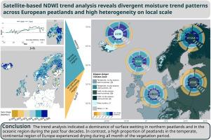
The satellite-derived moisture changes indicated a pronounced shift towards wetter conditions in the boreal and oceanic region of Europe, whereas in the temperate, continental region, a high proportion of peatlands experienced drying. Small-scale patterns of selected sites revealed a high spatial heterogeneity, the complexity of hydro-ecological interactions, and locally important environmental and anthropogenic drivers affecting the moisture signal. Overall, our results support the expected effects of current climate trends of increasing precipitation in boreal northern and oceanic north-western Europe and increasing frequency of drought in continental Europe.
Our fully reproducible approach provided new insights on continental and local scales, relevant not only to a better understanding of moisture trends in general, but also to practitioners and stakeholders in ecosystem management. It may thus contribute to developing a cost-effective long-term monitoring strategy for European peatlands.
求助全文
通过发布文献求助,成功后即可免费获取论文全文。 去求助
来源期刊
CiteScore
8.00
自引率
8.50%
发文量
204
审稿时长
65 days
期刊介绍: The journal ''Remote Sensing Applications: Society and Environment'' (RSASE) focuses on remote sensing studies that address specific topics with an emphasis on environmental and societal issues - regional / local studies with global significance. Subjects are encouraged to have an interdisciplinary approach and include, but are not limited by: " -Global and climate change studies addressing the impact of increasing concentrations of greenhouse gases, CO2 emission, carbon balance and carbon mitigation, energy system on social and environmental systems -Ecological and environmental issues including biodiversity, ecosystem dynamics, land degradation, atmospheric and water pollution, urban footprint, ecosystem management and natural hazards (e.g. earthquakes, typhoons, floods, landslides) -Natural resource studies including land-use in general, biomass estimation, forests, agricultural land, plantation, soils, coral reefs, wetland and water resources -Agriculture, food production systems and food security outcomes -Socio-economic issues including urban systems, urban growth, public health, epidemics, land-use transition and land use conflicts -Oceanography and coastal zone studies, including sea level rise projections, coastlines changes and the ocean-land interface -Regional challenges for remote sensing application techniques, monitoring and analysis, such as cloud screening and atmospheric correction for tropical regions -Interdisciplinary studies combining remote sensing, household survey data, field measurements and models to address environmental, societal and sustainability issues -Quantitative and qualitative analysis that documents the impact of using remote sensing studies in social, political, environmental or economic systems
×
引用
GB/T 7714-2015
复制
MLA
复制
APA
复制
导出至
BibTeX EndNote RefMan NoteFirst NoteExpress
×
提示
您的信息不完整,为了账户安全,请先补充。
现在去补充
×
提示
您因"违规操作"
具体请查看互助需知
我知道了
×
提示
确定
请完成安全验证×
copy
已复制链接
快去分享给好友吧!
我知道了
右上角分享
点击右上角分享
0
联系我们:info@booksci.cn Book学术提供免费学术资源搜索服务,方便国内外学者检索中英文文献。致力于提供最便捷和优质的服务体验。 Copyright © 2023 布克学术 All rights reserved.
京ICP备2023020795号-1
ghs 京公网安备 11010802042870号
Book学术文献互助
Book学术文献互助群
群 号:481959085
Book学术官方微信