{"title":"利用水文地质档案数据增进对西非硬岩含水层的水动力知识","authors":"Mozimwè Ani , Jessy Jaunat , Béatrice Marin , Frederic Huneau , Kissao Gnandi","doi":"10.1016/j.jafrearsci.2024.105477","DOIUrl":null,"url":null,"abstract":"<div><div>In the Kara River Watershed (KRW, northern Togo), drinking water is mainly supplied by groundwater flowing through fissures in the metamorphic formations of the Dahomeyides belt. The study was based on the use and valorisation of hydrogeological archive dataset from 1970s to 2021. The database comprises 1389 boreholes, but only 710 are considered after pre-treatment, and provides information mainly on total depth, weathering thickness, discharge at drilling, piezometric level, specific discharge, transmissivity, and the nature of the lithology tapped. The methodological approach involved statistical analysis of data, characterization of the fissured horizon, establishment of relationships between hydrodynamic parameters and satellite image processing. The results showed that the aquifers structure is close to those observed worldwide in hardrock context and they provide operational details on the hydrogeological functioning of these environments in the West African particular context. From the surface downwards, aquifers show a layer of saprolite (thickness between 0.2 and 37.3 m) acting as a storage level, a fissured layer whose permeability depends on the number and connectivity of the fissures, and then a level of very low permeability, unfissured bedrock. In the study area, the depth of the useful fissured medium is 52 m with an average useful discharge of 7.1 m<sup>3</sup> h<sup>−1</sup>. The coefficients of variation for specific discharge and transmissivity are greater than 100%, reflecting the structural heterogeneity of the study area. Analysis of the discharges measured in the boreholes as a function of lithology shows that the metasediments are more productive than other geological formations. Finally, all the geological, hydrogeological, and hydrodynamical data have been used to propose a preliminary conceptual model of the watershed's hardrock aquifers. These results will serve as decision-making tools for water managers and will facilitate the policy of integrated management of groundwater resources at the scale of the KRW. The developed methodology also shows how archive data should be used to achieve optimized management of aquifers without major investments.</div></div>","PeriodicalId":14874,"journal":{"name":"Journal of African Earth Sciences","volume":"221 ","pages":"Article 105477"},"PeriodicalIF":2.2000,"publicationDate":"2024-11-07","publicationTypes":"Journal Article","fieldsOfStudy":null,"isOpenAccess":false,"openAccessPdf":"","citationCount":"0","resultStr":"{\"title\":\"Using archive hydrogeological data to enhance the hydrodynamic knowledge of hardrock aquifers in Western Africa\",\"authors\":\"Mozimwè Ani , Jessy Jaunat , Béatrice Marin , Frederic Huneau , Kissao Gnandi\",\"doi\":\"10.1016/j.jafrearsci.2024.105477\",\"DOIUrl\":null,\"url\":null,\"abstract\":\"<div><div>In the Kara River Watershed (KRW, northern Togo), drinking water is mainly supplied by groundwater flowing through fissures in the metamorphic formations of the Dahomeyides belt. The study was based on the use and valorisation of hydrogeological archive dataset from 1970s to 2021. The database comprises 1389 boreholes, but only 710 are considered after pre-treatment, and provides information mainly on total depth, weathering thickness, discharge at drilling, piezometric level, specific discharge, transmissivity, and the nature of the lithology tapped. The methodological approach involved statistical analysis of data, characterization of the fissured horizon, establishment of relationships between hydrodynamic parameters and satellite image processing. The results showed that the aquifers structure is close to those observed worldwide in hardrock context and they provide operational details on the hydrogeological functioning of these environments in the West African particular context. From the surface downwards, aquifers show a layer of saprolite (thickness between 0.2 and 37.3 m) acting as a storage level, a fissured layer whose permeability depends on the number and connectivity of the fissures, and then a level of very low permeability, unfissured bedrock. In the study area, the depth of the useful fissured medium is 52 m with an average useful discharge of 7.1 m<sup>3</sup> h<sup>−1</sup>. The coefficients of variation for specific discharge and transmissivity are greater than 100%, reflecting the structural heterogeneity of the study area. Analysis of the discharges measured in the boreholes as a function of lithology shows that the metasediments are more productive than other geological formations. Finally, all the geological, hydrogeological, and hydrodynamical data have been used to propose a preliminary conceptual model of the watershed's hardrock aquifers. These results will serve as decision-making tools for water managers and will facilitate the policy of integrated management of groundwater resources at the scale of the KRW. The developed methodology also shows how archive data should be used to achieve optimized management of aquifers without major investments.</div></div>\",\"PeriodicalId\":14874,\"journal\":{\"name\":\"Journal of African Earth Sciences\",\"volume\":\"221 \",\"pages\":\"Article 105477\"},\"PeriodicalIF\":2.2000,\"publicationDate\":\"2024-11-07\",\"publicationTypes\":\"Journal Article\",\"fieldsOfStudy\":null,\"isOpenAccess\":false,\"openAccessPdf\":\"\",\"citationCount\":\"0\",\"resultStr\":null,\"platform\":\"Semanticscholar\",\"paperid\":null,\"PeriodicalName\":\"Journal of African Earth Sciences\",\"FirstCategoryId\":\"89\",\"ListUrlMain\":\"https://www.sciencedirect.com/science/article/pii/S1464343X2400311X\",\"RegionNum\":4,\"RegionCategory\":\"地球科学\",\"ArticlePicture\":[],\"TitleCN\":null,\"AbstractTextCN\":null,\"PMCID\":null,\"EPubDate\":\"\",\"PubModel\":\"\",\"JCR\":\"Q2\",\"JCRName\":\"GEOSCIENCES, MULTIDISCIPLINARY\",\"Score\":null,\"Total\":0}","platform":"Semanticscholar","paperid":null,"PeriodicalName":"Journal of African Earth Sciences","FirstCategoryId":"89","ListUrlMain":"https://www.sciencedirect.com/science/article/pii/S1464343X2400311X","RegionNum":4,"RegionCategory":"地球科学","ArticlePicture":[],"TitleCN":null,"AbstractTextCN":null,"PMCID":null,"EPubDate":"","PubModel":"","JCR":"Q2","JCRName":"GEOSCIENCES, MULTIDISCIPLINARY","Score":null,"Total":0}
Using archive hydrogeological data to enhance the hydrodynamic knowledge of hardrock aquifers in Western Africa
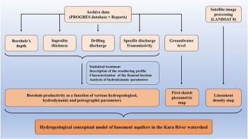
In the Kara River Watershed (KRW, northern Togo), drinking water is mainly supplied by groundwater flowing through fissures in the metamorphic formations of the Dahomeyides belt. The study was based on the use and valorisation of hydrogeological archive dataset from 1970s to 2021. The database comprises 1389 boreholes, but only 710 are considered after pre-treatment, and provides information mainly on total depth, weathering thickness, discharge at drilling, piezometric level, specific discharge, transmissivity, and the nature of the lithology tapped. The methodological approach involved statistical analysis of data, characterization of the fissured horizon, establishment of relationships between hydrodynamic parameters and satellite image processing. The results showed that the aquifers structure is close to those observed worldwide in hardrock context and they provide operational details on the hydrogeological functioning of these environments in the West African particular context. From the surface downwards, aquifers show a layer of saprolite (thickness between 0.2 and 37.3 m) acting as a storage level, a fissured layer whose permeability depends on the number and connectivity of the fissures, and then a level of very low permeability, unfissured bedrock. In the study area, the depth of the useful fissured medium is 52 m with an average useful discharge of 7.1 m3 h−1. The coefficients of variation for specific discharge and transmissivity are greater than 100%, reflecting the structural heterogeneity of the study area. Analysis of the discharges measured in the boreholes as a function of lithology shows that the metasediments are more productive than other geological formations. Finally, all the geological, hydrogeological, and hydrodynamical data have been used to propose a preliminary conceptual model of the watershed's hardrock aquifers. These results will serve as decision-making tools for water managers and will facilitate the policy of integrated management of groundwater resources at the scale of the KRW. The developed methodology also shows how archive data should be used to achieve optimized management of aquifers without major investments.
期刊介绍:
The Journal of African Earth Sciences sees itself as the prime geological journal for all aspects of the Earth Sciences about the African plate. Papers dealing with peripheral areas are welcome if they demonstrate a tight link with Africa.
The Journal publishes high quality, peer-reviewed scientific papers. It is devoted primarily to research papers but short communications relating to new developments of broad interest, reviews and book reviews will also be considered. Papers must have international appeal and should present work of more regional than local significance and dealing with well identified and justified scientific questions. Specialised technical papers, analytical or exploration reports must be avoided. Papers on applied geology should preferably be linked to such core disciplines and must be addressed to a more general geoscientific audience.