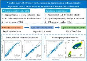
结合深度不变指数和自适应对数比率的卫星水深测量方法:西沙群岛无现场测量的案例研究

IF 7.6 Q1 REMOTE SENSING
Xiangtao Zhao , Chao Qi , Jianhua Zhu , Dianpeng Su , Fanlin Yang , Jinshan Zhu
{"title":"结合深度不变指数和自适应对数比率的卫星水深测量方法:西沙群岛无现场测量的案例研究","authors":"Xiangtao Zhao ,&nbsp;Chao Qi ,&nbsp;Jianhua Zhu ,&nbsp;Dianpeng Su ,&nbsp;Fanlin Yang ,&nbsp;Jinshan Zhu","doi":"10.1016/j.jag.2024.104232","DOIUrl":null,"url":null,"abstract":"<div><div>Accurate bathymetric data is crucial for various aspects such as marine resource exploitation and marine ecological conservation. Currently, satellite-derived bathymetry (SDB) based on empirical and physical models has been widely utilized in constructing underwater terrain in shallow seas. However, the application of such SDB models is limited in remote island reef areas lacking <em>in-situ</em> measurement data. To overcome this issue, the manuscript proposes an unconstrained SDB optimization method without <em>in-situ</em> measurement data, utilizing satellite multispectral imagery (Geoeye-1) and spaceborne LiDAR data (ICESat-2). By classifying the seafloor substrate in coral reef areas into sandy and coral, based on the depth invariant index (DII), we employ an adaptive logarithmic ratio model for unconstrained SDB. The ICESat-2 LiDAR data are then used to correct the SDB results, achieving bathymetry optimization in the coral reef area of the Xisha Islands. Additionally, the proposed method is applied to Yuanzhi Island of the Xisha Islands, and the accuracy of the bathymetric results is evaluated against ALB (Airborne LiDAR Bathymetry) data. The findings demonstrate that compared to conventional methods, our method can improve the accuracy of SDB results with good adaptability. In the Yuanzhi Island area, the proposed method yields SDB results with an R<sup>2</sup> of 0.93, an MAE (Mean Absolute Error) of 0.94, and an RMSE (Root Mean Square Error) of 1.12 m, compared to ALB data. The average error is less than 10 % of the maximum depth, essentially meeting the requirements of the International Hydrographic Organization (IHO) standards for depth measurement error when depth is &lt;20 m. This study can offer a novel approach for enhancing bathymetric accuracy around offshore and remote islands, where gathering underwater terrain data is challenging.</div></div>","PeriodicalId":73423,"journal":{"name":"International journal of applied earth observation and geoinformation : ITC journal","volume":"134 ","pages":"Article 104232"},"PeriodicalIF":7.6000,"publicationDate":"2024-10-23","publicationTypes":"Journal Article","fieldsOfStudy":null,"isOpenAccess":false,"openAccessPdf":"","citationCount":"0","resultStr":"{\"title\":\"A satellite-derived bathymetry method combining depth invariant index and adaptive logarithmic ratio: A case study in the Xisha Islands without in-situ measurements\",\"authors\":\"Xiangtao Zhao ,&nbsp;Chao Qi ,&nbsp;Jianhua Zhu ,&nbsp;Dianpeng Su ,&nbsp;Fanlin Yang ,&nbsp;Jinshan Zhu\",\"doi\":\"10.1016/j.jag.2024.104232\",\"DOIUrl\":null,\"url\":null,\"abstract\":\"<div><div>Accurate bathymetric data is crucial for various aspects such as marine resource exploitation and marine ecological conservation. Currently, satellite-derived bathymetry (SDB) based on empirical and physical models has been widely utilized in constructing underwater terrain in shallow seas. However, the application of such SDB models is limited in remote island reef areas lacking <em>in-situ</em> measurement data. To overcome this issue, the manuscript proposes an unconstrained SDB optimization method without <em>in-situ</em> measurement data, utilizing satellite multispectral imagery (Geoeye-1) and spaceborne LiDAR data (ICESat-2). By classifying the seafloor substrate in coral reef areas into sandy and coral, based on the depth invariant index (DII), we employ an adaptive logarithmic ratio model for unconstrained SDB. The ICESat-2 LiDAR data are then used to correct the SDB results, achieving bathymetry optimization in the coral reef area of the Xisha Islands. Additionally, the proposed method is applied to Yuanzhi Island of the Xisha Islands, and the accuracy of the bathymetric results is evaluated against ALB (Airborne LiDAR Bathymetry) data. The findings demonstrate that compared to conventional methods, our method can improve the accuracy of SDB results with good adaptability. In the Yuanzhi Island area, the proposed method yields SDB results with an R<sup>2</sup> of 0.93, an MAE (Mean Absolute Error) of 0.94, and an RMSE (Root Mean Square Error) of 1.12 m, compared to ALB data. The average error is less than 10 % of the maximum depth, essentially meeting the requirements of the International Hydrographic Organization (IHO) standards for depth measurement error when depth is &lt;20 m. This study can offer a novel approach for enhancing bathymetric accuracy around offshore and remote islands, where gathering underwater terrain data is challenging.</div></div>\",\"PeriodicalId\":73423,\"journal\":{\"name\":\"International journal of applied earth observation and geoinformation : ITC journal\",\"volume\":\"134 \",\"pages\":\"Article 104232\"},\"PeriodicalIF\":7.6000,\"publicationDate\":\"2024-10-23\",\"publicationTypes\":\"Journal Article\",\"fieldsOfStudy\":null,\"isOpenAccess\":false,\"openAccessPdf\":\"\",\"citationCount\":\"0\",\"resultStr\":null,\"platform\":\"Semanticscholar\",\"paperid\":null,\"PeriodicalName\":\"International journal of applied earth observation and geoinformation : ITC journal\",\"FirstCategoryId\":\"1085\",\"ListUrlMain\":\"https://www.sciencedirect.com/science/article/pii/S1569843224005880\",\"RegionNum\":0,\"RegionCategory\":null,\"ArticlePicture\":[],\"TitleCN\":null,\"AbstractTextCN\":null,\"PMCID\":null,\"EPubDate\":\"\",\"PubModel\":\"\",\"JCR\":\"Q1\",\"JCRName\":\"REMOTE SENSING\",\"Score\":null,\"Total\":0}","platform":"Semanticscholar","paperid":null,"PeriodicalName":"International journal of applied earth observation and geoinformation : ITC journal","FirstCategoryId":"1085","ListUrlMain":"https://www.sciencedirect.com/science/article/pii/S1569843224005880","RegionNum":0,"RegionCategory":null,"ArticlePicture":[],"TitleCN":null,"AbstractTextCN":null,"PMCID":null,"EPubDate":"","PubModel":"","JCR":"Q1","JCRName":"REMOTE SENSING","Score":null,"Total":0}
引用次数: 0

摘要

准确的测深数据对海洋资源开发和海洋生态保护等各个方面都至关重要。目前,基于经验和物理模型的卫星水深测量(SDB)已被广泛用于构建浅海水下地形。然而,在缺乏原位测量数据的偏远岛礁地区,此类 SDB 模型的应用受到限制。为克服这一问题,手稿提出了一种无约束 SDB 优化方法,利用卫星多光谱图像(Geoeye-1)和空间激光雷达数据(ICESat-2),无需原位测量数据。根据深度不变指数(DII)将珊瑚礁区域的海底基质分为沙质和珊瑚质,我们采用自适应对数比率模型进行无约束 SDB。然后利用 ICESat-2 LiDAR 数据修正 SDB 结果,实现了西沙群岛珊瑚礁区域的水深优化。此外,还将该方法应用于西沙群岛的远志岛,并对照 ALB(机载激光雷达测深)数据评估了测深结果的准确性。结果表明,与传统方法相比,我们的方法可以提高 SDB 结果的精度,并具有良好的适应性。在远志岛地区,与 ALB 数据相比,建议方法得到的 SDB 结果 R2 为 0.93,MAE(平均绝对误差)为 0.94,RMSE(均方根误差)为 1.12 米。平均误差小于最大深度的 10%,基本符合国际水文组织(IHO)关于深度为 20 米时深度测量误差的标准要求。这项研究为提高近海和偏远岛屿周围的测深精度提供了一种新方法,因为在这些地方收集水下地形数据具有挑战性。
本文章由计算机程序翻译,如有差异,请以英文原文为准。

A satellite-derived bathymetry method combining depth invariant index and adaptive logarithmic ratio: A case study in the Xisha Islands without in-situ measurements

A satellite-derived bathymetry method combining depth invariant index and adaptive logarithmic ratio: A case study in the Xisha Islands without in-situ measurements
Accurate bathymetric data is crucial for various aspects such as marine resource exploitation and marine ecological conservation. Currently, satellite-derived bathymetry (SDB) based on empirical and physical models has been widely utilized in constructing underwater terrain in shallow seas. However, the application of such SDB models is limited in remote island reef areas lacking in-situ measurement data. To overcome this issue, the manuscript proposes an unconstrained SDB optimization method without in-situ measurement data, utilizing satellite multispectral imagery (Geoeye-1) and spaceborne LiDAR data (ICESat-2). By classifying the seafloor substrate in coral reef areas into sandy and coral, based on the depth invariant index (DII), we employ an adaptive logarithmic ratio model for unconstrained SDB. The ICESat-2 LiDAR data are then used to correct the SDB results, achieving bathymetry optimization in the coral reef area of the Xisha Islands. Additionally, the proposed method is applied to Yuanzhi Island of the Xisha Islands, and the accuracy of the bathymetric results is evaluated against ALB (Airborne LiDAR Bathymetry) data. The findings demonstrate that compared to conventional methods, our method can improve the accuracy of SDB results with good adaptability. In the Yuanzhi Island area, the proposed method yields SDB results with an R2 of 0.93, an MAE (Mean Absolute Error) of 0.94, and an RMSE (Root Mean Square Error) of 1.12 m, compared to ALB data. The average error is less than 10 % of the maximum depth, essentially meeting the requirements of the International Hydrographic Organization (IHO) standards for depth measurement error when depth is <20 m. This study can offer a novel approach for enhancing bathymetric accuracy around offshore and remote islands, where gathering underwater terrain data is challenging.
求助全文
通过发布文献求助,成功后即可免费获取论文全文。 去求助
来源期刊
International journal of applied earth observation and geoinformation : ITC journal
International journal of applied earth observation and geoinformation : ITC journal Global and Planetary Change, Management, Monitoring, Policy and Law, Earth-Surface Processes, Computers in Earth Sciences
CiteScore
12.00
自引率
0.00%
发文量
0
审稿时长
77 days
期刊介绍: The International Journal of Applied Earth Observation and Geoinformation publishes original papers that utilize earth observation data for natural resource and environmental inventory and management. These data primarily originate from remote sensing platforms, including satellites and aircraft, supplemented by surface and subsurface measurements. Addressing natural resources such as forests, agricultural land, soils, and water, as well as environmental concerns like biodiversity, land degradation, and hazards, the journal explores conceptual and data-driven approaches. It covers geoinformation themes like capturing, databasing, visualization, interpretation, data quality, and spatial uncertainty.
×
引用
GB/T 7714-2015
复制
MLA
复制
APA
复制
导出至
BibTeX EndNote RefMan NoteFirst NoteExpress
×
提示
您的信息不完整,为了账户安全,请先补充。
现在去补充
×
提示
您因"违规操作"
具体请查看互助需知
我知道了
×
提示
确定
请完成安全验证×
copy
已复制链接
快去分享给好友吧!
我知道了
右上角分享
点击右上角分享
0
联系我们:info@booksci.cn Book学术提供免费学术资源搜索服务,方便国内外学者检索中英文文献。致力于提供最便捷和优质的服务体验。 Copyright © 2023 布克学术 All rights reserved.
京ICP备2023020795号-1
ghs 京公网安备 11010802042870号
Book学术文献互助
Book学术文献互助群
群 号:481959085
Book学术官方微信