{"title":"阿曼苏丹国东北部断陷后苏努布构造的结构:基于测绘、三维重力反演和页岩迁移","authors":"","doi":"10.1016/j.jafrearsci.2024.105445","DOIUrl":null,"url":null,"abstract":"<div><div>We examined the structural evolution of the poorly understood Sunub Structure, which is associated with the northern margin of the Saih Hatat Dome and the extensional Frontal Range Fault (northeastern Oman). The Sunub Structure is located at a dextral transtensional segment and on the hanging wall of the NNE-striking Frontal Range Fault. The fault was active during the Campanian(?)/Maastrichtian to early Eocene (Interval I) and mid-/late Eocene to early Miocene (Interval II). Gravitational inversion using 175 stations and mapping shows: (1) The Sunub Structure is possibly >1200–1350 m deep and filled mostly with the >900-m-thick Campanian(?)/Maastrichtian siliciclastic Al-Khod Formation, including shale, and some overlying Paleogene limestones. (2) The bottom of the basin cannot be depicted. (3) The lower part of the structure is a basin (Sunub Sedimentary Basin), bounded by sub-vertical to steep contacts. (4) The upper part of the Sunub Structure is a basin fold displaying a bowl-shape down to ∼300 m below the surface, referred to as the Sunub Bowl. (5) The bowl is cut by radial faults and five ∼E/W-striking transverse faults. The Sunub Structure formed during Interval I as a deep transtensional, syn-depositional basin. Gentle post-depositional tectonics during Interval II and visco-plastic shale movements produced the present-day bowl-shape that is visible at the surface. Gravitational inversion depict possible evidence for shale migration within the Al-Khod Formation. Although no hydrocarbons are present, the Sunub Structure can serve as an analogue for hydrocarbon migration and storage in similar structures.</div></div>","PeriodicalId":14874,"journal":{"name":"Journal of African Earth Sciences","volume":null,"pages":null},"PeriodicalIF":2.2000,"publicationDate":"2024-10-10","publicationTypes":"Journal Article","fieldsOfStudy":null,"isOpenAccess":false,"openAccessPdf":"","citationCount":"0","resultStr":"{\"title\":\"Architecture of the post-obductional Sunub Structure, northeastern Sultanate of Oman: Based on mapping, 3D gravity inversion and shale migration\",\"authors\":\"\",\"doi\":\"10.1016/j.jafrearsci.2024.105445\",\"DOIUrl\":null,\"url\":null,\"abstract\":\"<div><div>We examined the structural evolution of the poorly understood Sunub Structure, which is associated with the northern margin of the Saih Hatat Dome and the extensional Frontal Range Fault (northeastern Oman). The Sunub Structure is located at a dextral transtensional segment and on the hanging wall of the NNE-striking Frontal Range Fault. The fault was active during the Campanian(?)/Maastrichtian to early Eocene (Interval I) and mid-/late Eocene to early Miocene (Interval II). Gravitational inversion using 175 stations and mapping shows: (1) The Sunub Structure is possibly >1200–1350 m deep and filled mostly with the >900-m-thick Campanian(?)/Maastrichtian siliciclastic Al-Khod Formation, including shale, and some overlying Paleogene limestones. (2) The bottom of the basin cannot be depicted. (3) The lower part of the structure is a basin (Sunub Sedimentary Basin), bounded by sub-vertical to steep contacts. (4) The upper part of the Sunub Structure is a basin fold displaying a bowl-shape down to ∼300 m below the surface, referred to as the Sunub Bowl. (5) The bowl is cut by radial faults and five ∼E/W-striking transverse faults. The Sunub Structure formed during Interval I as a deep transtensional, syn-depositional basin. Gentle post-depositional tectonics during Interval II and visco-plastic shale movements produced the present-day bowl-shape that is visible at the surface. Gravitational inversion depict possible evidence for shale migration within the Al-Khod Formation. Although no hydrocarbons are present, the Sunub Structure can serve as an analogue for hydrocarbon migration and storage in similar structures.</div></div>\",\"PeriodicalId\":14874,\"journal\":{\"name\":\"Journal of African Earth Sciences\",\"volume\":null,\"pages\":null},\"PeriodicalIF\":2.2000,\"publicationDate\":\"2024-10-10\",\"publicationTypes\":\"Journal Article\",\"fieldsOfStudy\":null,\"isOpenAccess\":false,\"openAccessPdf\":\"\",\"citationCount\":\"0\",\"resultStr\":null,\"platform\":\"Semanticscholar\",\"paperid\":null,\"PeriodicalName\":\"Journal of African Earth Sciences\",\"FirstCategoryId\":\"89\",\"ListUrlMain\":\"https://www.sciencedirect.com/science/article/pii/S1464343X24002784\",\"RegionNum\":4,\"RegionCategory\":\"地球科学\",\"ArticlePicture\":[],\"TitleCN\":null,\"AbstractTextCN\":null,\"PMCID\":null,\"EPubDate\":\"\",\"PubModel\":\"\",\"JCR\":\"Q2\",\"JCRName\":\"GEOSCIENCES, MULTIDISCIPLINARY\",\"Score\":null,\"Total\":0}","platform":"Semanticscholar","paperid":null,"PeriodicalName":"Journal of African Earth Sciences","FirstCategoryId":"89","ListUrlMain":"https://www.sciencedirect.com/science/article/pii/S1464343X24002784","RegionNum":4,"RegionCategory":"地球科学","ArticlePicture":[],"TitleCN":null,"AbstractTextCN":null,"PMCID":null,"EPubDate":"","PubModel":"","JCR":"Q2","JCRName":"GEOSCIENCES, MULTIDISCIPLINARY","Score":null,"Total":0}
Architecture of the post-obductional Sunub Structure, northeastern Sultanate of Oman: Based on mapping, 3D gravity inversion and shale migration
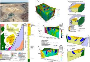
We examined the structural evolution of the poorly understood Sunub Structure, which is associated with the northern margin of the Saih Hatat Dome and the extensional Frontal Range Fault (northeastern Oman). The Sunub Structure is located at a dextral transtensional segment and on the hanging wall of the NNE-striking Frontal Range Fault. The fault was active during the Campanian(?)/Maastrichtian to early Eocene (Interval I) and mid-/late Eocene to early Miocene (Interval II). Gravitational inversion using 175 stations and mapping shows: (1) The Sunub Structure is possibly >1200–1350 m deep and filled mostly with the >900-m-thick Campanian(?)/Maastrichtian siliciclastic Al-Khod Formation, including shale, and some overlying Paleogene limestones. (2) The bottom of the basin cannot be depicted. (3) The lower part of the structure is a basin (Sunub Sedimentary Basin), bounded by sub-vertical to steep contacts. (4) The upper part of the Sunub Structure is a basin fold displaying a bowl-shape down to ∼300 m below the surface, referred to as the Sunub Bowl. (5) The bowl is cut by radial faults and five ∼E/W-striking transverse faults. The Sunub Structure formed during Interval I as a deep transtensional, syn-depositional basin. Gentle post-depositional tectonics during Interval II and visco-plastic shale movements produced the present-day bowl-shape that is visible at the surface. Gravitational inversion depict possible evidence for shale migration within the Al-Khod Formation. Although no hydrocarbons are present, the Sunub Structure can serve as an analogue for hydrocarbon migration and storage in similar structures.
期刊介绍:
The Journal of African Earth Sciences sees itself as the prime geological journal for all aspects of the Earth Sciences about the African plate. Papers dealing with peripheral areas are welcome if they demonstrate a tight link with Africa.
The Journal publishes high quality, peer-reviewed scientific papers. It is devoted primarily to research papers but short communications relating to new developments of broad interest, reviews and book reviews will also be considered. Papers must have international appeal and should present work of more regional than local significance and dealing with well identified and justified scientific questions. Specialised technical papers, analytical or exploration reports must be avoided. Papers on applied geology should preferably be linked to such core disciplines and must be addressed to a more general geoscientific audience.