{"title":"利用卫星时间序列进行连续土地覆被变化监测和语义分割的快速混合方法","authors":"Wenpeng Zhao , Rongfang Lyu , Jinming Zhang , Jili Pang , Jianming Zhang","doi":"10.1016/j.jag.2024.104222","DOIUrl":null,"url":null,"abstract":"<div><div>Land cover change detection and classification, including both inter-class changes (land cover conversion, LCC) and intra-class changes (land cover modification, LCM), is critical for understanding the Earth’s dynamic processes and promoting sustainability. However, previous studies have predominantly focused on LCC, with less emphasis on LCM. Land cover classification remains challenging, and its mapping results are often affected by salt and pepper noise. Here, we propose a hybrid approach for continuous change detection and classification of LCC and LCM using Jinchang City, China, as a case study. Firstly, we combined the Continuous Change Detection and Classification (CCDC) and the Bayesian Estimator of Abrupt change, Seasonal change, and Trend (BEAST) algorithms to identify LCC and LCM using all available Landsat time series (TS) data from 2000 to 2020. Then, the harmonic regression coefficients and RMSE values derived from CCDC (hereafter called CCDC features) were fed into the DCNN model for LCC classification. Our findings indicate: (1) For LCC and LCM accuracy assessment, the CCDC and BEAST ensemble achieved a spatial F1 score of 82.7% and an average temporal F1 score of 79.7%. (2) In LCC classification, the DCNN model with CCDC features, particularly DeepLabV3+, outperformed the pixel-based XGBoost and other multi-year land cover products, with frequency-weighted intersection over union (FWIoU), overall accuracy, and Kappa scores of 88.7%, 94%, and 0.87, respectively. (3) Seasonal LCM showed a more concentrated distribution than trend LCM. (4) In Jinchang City, LCM larger than LCC in area, and grassland and cultivated land are the most distributed. Our approach can be contributed to wall-to-wall land surface monitoring and enhance land management capabilities.</div></div>","PeriodicalId":73423,"journal":{"name":"International journal of applied earth observation and geoinformation : ITC journal","volume":"134 ","pages":"Article 104222"},"PeriodicalIF":7.6000,"publicationDate":"2024-10-17","publicationTypes":"Journal Article","fieldsOfStudy":null,"isOpenAccess":false,"openAccessPdf":"","citationCount":"0","resultStr":"{\"title\":\"A fast hybrid approach for continuous land cover change monitoring and semantic segmentation using satellite time series\",\"authors\":\"Wenpeng Zhao , Rongfang Lyu , Jinming Zhang , Jili Pang , Jianming Zhang\",\"doi\":\"10.1016/j.jag.2024.104222\",\"DOIUrl\":null,\"url\":null,\"abstract\":\"<div><div>Land cover change detection and classification, including both inter-class changes (land cover conversion, LCC) and intra-class changes (land cover modification, LCM), is critical for understanding the Earth’s dynamic processes and promoting sustainability. However, previous studies have predominantly focused on LCC, with less emphasis on LCM. Land cover classification remains challenging, and its mapping results are often affected by salt and pepper noise. Here, we propose a hybrid approach for continuous change detection and classification of LCC and LCM using Jinchang City, China, as a case study. Firstly, we combined the Continuous Change Detection and Classification (CCDC) and the Bayesian Estimator of Abrupt change, Seasonal change, and Trend (BEAST) algorithms to identify LCC and LCM using all available Landsat time series (TS) data from 2000 to 2020. Then, the harmonic regression coefficients and RMSE values derived from CCDC (hereafter called CCDC features) were fed into the DCNN model for LCC classification. Our findings indicate: (1) For LCC and LCM accuracy assessment, the CCDC and BEAST ensemble achieved a spatial F1 score of 82.7% and an average temporal F1 score of 79.7%. (2) In LCC classification, the DCNN model with CCDC features, particularly DeepLabV3+, outperformed the pixel-based XGBoost and other multi-year land cover products, with frequency-weighted intersection over union (FWIoU), overall accuracy, and Kappa scores of 88.7%, 94%, and 0.87, respectively. (3) Seasonal LCM showed a more concentrated distribution than trend LCM. (4) In Jinchang City, LCM larger than LCC in area, and grassland and cultivated land are the most distributed. Our approach can be contributed to wall-to-wall land surface monitoring and enhance land management capabilities.</div></div>\",\"PeriodicalId\":73423,\"journal\":{\"name\":\"International journal of applied earth observation and geoinformation : ITC journal\",\"volume\":\"134 \",\"pages\":\"Article 104222\"},\"PeriodicalIF\":7.6000,\"publicationDate\":\"2024-10-17\",\"publicationTypes\":\"Journal Article\",\"fieldsOfStudy\":null,\"isOpenAccess\":false,\"openAccessPdf\":\"\",\"citationCount\":\"0\",\"resultStr\":null,\"platform\":\"Semanticscholar\",\"paperid\":null,\"PeriodicalName\":\"International journal of applied earth observation and geoinformation : ITC journal\",\"FirstCategoryId\":\"1085\",\"ListUrlMain\":\"https://www.sciencedirect.com/science/article/pii/S1569843224005788\",\"RegionNum\":0,\"RegionCategory\":null,\"ArticlePicture\":[],\"TitleCN\":null,\"AbstractTextCN\":null,\"PMCID\":null,\"EPubDate\":\"\",\"PubModel\":\"\",\"JCR\":\"Q1\",\"JCRName\":\"REMOTE SENSING\",\"Score\":null,\"Total\":0}","platform":"Semanticscholar","paperid":null,"PeriodicalName":"International journal of applied earth observation and geoinformation : ITC journal","FirstCategoryId":"1085","ListUrlMain":"https://www.sciencedirect.com/science/article/pii/S1569843224005788","RegionNum":0,"RegionCategory":null,"ArticlePicture":[],"TitleCN":null,"AbstractTextCN":null,"PMCID":null,"EPubDate":"","PubModel":"","JCR":"Q1","JCRName":"REMOTE SENSING","Score":null,"Total":0}
A fast hybrid approach for continuous land cover change monitoring and semantic segmentation using satellite time series
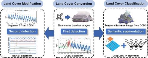
Land cover change detection and classification, including both inter-class changes (land cover conversion, LCC) and intra-class changes (land cover modification, LCM), is critical for understanding the Earth’s dynamic processes and promoting sustainability. However, previous studies have predominantly focused on LCC, with less emphasis on LCM. Land cover classification remains challenging, and its mapping results are often affected by salt and pepper noise. Here, we propose a hybrid approach for continuous change detection and classification of LCC and LCM using Jinchang City, China, as a case study. Firstly, we combined the Continuous Change Detection and Classification (CCDC) and the Bayesian Estimator of Abrupt change, Seasonal change, and Trend (BEAST) algorithms to identify LCC and LCM using all available Landsat time series (TS) data from 2000 to 2020. Then, the harmonic regression coefficients and RMSE values derived from CCDC (hereafter called CCDC features) were fed into the DCNN model for LCC classification. Our findings indicate: (1) For LCC and LCM accuracy assessment, the CCDC and BEAST ensemble achieved a spatial F1 score of 82.7% and an average temporal F1 score of 79.7%. (2) In LCC classification, the DCNN model with CCDC features, particularly DeepLabV3+, outperformed the pixel-based XGBoost and other multi-year land cover products, with frequency-weighted intersection over union (FWIoU), overall accuracy, and Kappa scores of 88.7%, 94%, and 0.87, respectively. (3) Seasonal LCM showed a more concentrated distribution than trend LCM. (4) In Jinchang City, LCM larger than LCC in area, and grassland and cultivated land are the most distributed. Our approach can be contributed to wall-to-wall land surface monitoring and enhance land management capabilities.
期刊介绍:
The International Journal of Applied Earth Observation and Geoinformation publishes original papers that utilize earth observation data for natural resource and environmental inventory and management. These data primarily originate from remote sensing platforms, including satellites and aircraft, supplemented by surface and subsurface measurements. Addressing natural resources such as forests, agricultural land, soils, and water, as well as environmental concerns like biodiversity, land degradation, and hazards, the journal explores conceptual and data-driven approaches. It covers geoinformation themes like capturing, databasing, visualization, interpretation, data quality, and spatial uncertainty.