GAM4water:基于 R 的从遥感图像中提取湿润区域的方法

IF 1.6 Q2 MULTIDISCIPLINARY SCIENCES
MethodsX Pub Date : 2024-09-10 DOI:10.1016/j.mex.2024.102955
{"title":"GAM4water:基于 R 的从遥感图像中提取湿润区域的方法","authors":"","doi":"10.1016/j.mex.2024.102955","DOIUrl":null,"url":null,"abstract":"<div><div>We present ‘GAM4water,’ a R-based method to classify wetted and non-wetted (dry) areas using remotely sensed image indices derived from such images. The GAM4water classification algorithm is built around a Generalized Additive Model (GAM) capable of accounting for non-linear responses. GAM4water can use any type of radiometric data, whether from drones, satellites or other platforms, and can be used with data of different spatial resolutions, geographic extents and spatial reference systems. It is a supervised tool that uses pixel information to distinguish between wetted and dry areas within an image set, extract them and produce a rich output that includes a binary raster, polygons of wetted areas, and a classification performance report. We tested the method in two case-studies, one using high resolution drone images and another using satellite images. The tests show that GAM4water can produce highly accurate classifications of wetted and non-wetted areas, and has the additional benefit of being easily customizable and not requiring complex implementation procedures.<ul><li><span>•</span><span><div>This paper introduces the first R based method of wetted area extraction for remotely-sensed images.</div></span></li><li><span>•</span><span><div>The method is based on Generalized Additive Models and is applicable to any remotely-sensed data.</div></span></li></ul></div></div>","PeriodicalId":18446,"journal":{"name":"MethodsX","volume":null,"pages":null},"PeriodicalIF":1.6000,"publicationDate":"2024-09-10","publicationTypes":"Journal Article","fieldsOfStudy":null,"isOpenAccess":false,"openAccessPdf":"https://www.sciencedirect.com/science/article/pii/S2215016124004060/pdfft?md5=f3b7be30721e0a71e17718184a15d09a&pid=1-s2.0-S2215016124004060-main.pdf","citationCount":"0","resultStr":"{\"title\":\"GAM4water: An R-based method for extracting wetted areas from remotely-sensed images\",\"authors\":\"\",\"doi\":\"10.1016/j.mex.2024.102955\",\"DOIUrl\":null,\"url\":null,\"abstract\":\"<div><div>We present ‘GAM4water,’ a R-based method to classify wetted and non-wetted (dry) areas using remotely sensed image indices derived from such images. The GAM4water classification algorithm is built around a Generalized Additive Model (GAM) capable of accounting for non-linear responses. GAM4water can use any type of radiometric data, whether from drones, satellites or other platforms, and can be used with data of different spatial resolutions, geographic extents and spatial reference systems. It is a supervised tool that uses pixel information to distinguish between wetted and dry areas within an image set, extract them and produce a rich output that includes a binary raster, polygons of wetted areas, and a classification performance report. We tested the method in two case-studies, one using high resolution drone images and another using satellite images. The tests show that GAM4water can produce highly accurate classifications of wetted and non-wetted areas, and has the additional benefit of being easily customizable and not requiring complex implementation procedures.<ul><li><span>•</span><span><div>This paper introduces the first R based method of wetted area extraction for remotely-sensed images.</div></span></li><li><span>•</span><span><div>The method is based on Generalized Additive Models and is applicable to any remotely-sensed data.</div></span></li></ul></div></div>\",\"PeriodicalId\":18446,\"journal\":{\"name\":\"MethodsX\",\"volume\":null,\"pages\":null},\"PeriodicalIF\":1.6000,\"publicationDate\":\"2024-09-10\",\"publicationTypes\":\"Journal Article\",\"fieldsOfStudy\":null,\"isOpenAccess\":false,\"openAccessPdf\":\"https://www.sciencedirect.com/science/article/pii/S2215016124004060/pdfft?md5=f3b7be30721e0a71e17718184a15d09a&pid=1-s2.0-S2215016124004060-main.pdf\",\"citationCount\":\"0\",\"resultStr\":null,\"platform\":\"Semanticscholar\",\"paperid\":null,\"PeriodicalName\":\"MethodsX\",\"FirstCategoryId\":\"1085\",\"ListUrlMain\":\"https://www.sciencedirect.com/science/article/pii/S2215016124004060\",\"RegionNum\":0,\"RegionCategory\":null,\"ArticlePicture\":[],\"TitleCN\":null,\"AbstractTextCN\":null,\"PMCID\":null,\"EPubDate\":\"\",\"PubModel\":\"\",\"JCR\":\"Q2\",\"JCRName\":\"MULTIDISCIPLINARY SCIENCES\",\"Score\":null,\"Total\":0}","platform":"Semanticscholar","paperid":null,"PeriodicalName":"MethodsX","FirstCategoryId":"1085","ListUrlMain":"https://www.sciencedirect.com/science/article/pii/S2215016124004060","RegionNum":0,"RegionCategory":null,"ArticlePicture":[],"TitleCN":null,"AbstractTextCN":null,"PMCID":null,"EPubDate":"","PubModel":"","JCR":"Q2","JCRName":"MULTIDISCIPLINARY SCIENCES","Score":null,"Total":0}
引用次数: 0

摘要

我们介绍了 "GAM4water",这是一种基于 R 的方法,可利用从遥感图像中提取的图像指数对湿润和非湿润(干燥)区域进行分类。GAM4water 分类算法是围绕一个能够考虑非线性响应的广义相加模型(GAM)建立的。GAM4water 可使用任何类型的辐射测量数据,无论是来自无人机、卫星还是其他平台,并可用于不同空间分辨率、地理范围和空间参考系统的数据。它是一种有监督的工具,利用像素信息来区分图像集中的湿润区域和干燥区域,提取这些区域并生成丰富的输出,包括二进制栅格、湿润区域的多边形和分类性能报告。我们在两个案例研究中测试了该方法,一个使用高分辨率无人机图像,另一个使用卫星图像。测试结果表明,GAM4water 可以对湿润区域和非湿润区域进行高度精确的分类,而且还具有易于定制、无需复杂执行程序的额外优势。
本文章由计算机程序翻译,如有差异,请以英文原文为准。

GAM4water: An R-based method for extracting wetted areas from remotely-sensed images

GAM4water: An R-based method for extracting wetted areas from remotely-sensed images
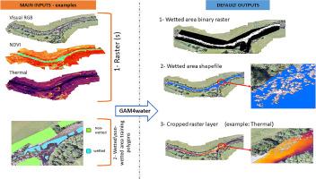
We present ‘GAM4water,’ a R-based method to classify wetted and non-wetted (dry) areas using remotely sensed image indices derived from such images. The GAM4water classification algorithm is built around a Generalized Additive Model (GAM) capable of accounting for non-linear responses. GAM4water can use any type of radiometric data, whether from drones, satellites or other platforms, and can be used with data of different spatial resolutions, geographic extents and spatial reference systems. It is a supervised tool that uses pixel information to distinguish between wetted and dry areas within an image set, extract them and produce a rich output that includes a binary raster, polygons of wetted areas, and a classification performance report. We tested the method in two case-studies, one using high resolution drone images and another using satellite images. The tests show that GAM4water can produce highly accurate classifications of wetted and non-wetted areas, and has the additional benefit of being easily customizable and not requiring complex implementation procedures.
  • This paper introduces the first R based method of wetted area extraction for remotely-sensed images.
  • The method is based on Generalized Additive Models and is applicable to any remotely-sensed data.
求助全文
通过发布文献求助,成功后即可免费获取论文全文。 去求助
来源期刊
MethodsX
MethodsX Health Professions-Medical Laboratory Technology
CiteScore
3.60
自引率
5.30%
发文量
314
审稿时长
7 weeks
×
引用
GB/T 7714-2015
复制
MLA
复制
APA
复制
导出至
BibTeX EndNote RefMan NoteFirst NoteExpress
×
提示
您的信息不完整,为了账户安全,请先补充。
现在去补充
×
提示
您因"违规操作"
具体请查看互助需知
我知道了
×
提示
确定
请完成安全验证×
copy
已复制链接
快去分享给好友吧!
我知道了
右上角分享
点击右上角分享
0
联系我们:info@booksci.cn Book学术提供免费学术资源搜索服务,方便国内外学者检索中英文文献。致力于提供最便捷和优质的服务体验。 Copyright © 2023 布克学术 All rights reserved.
京ICP备2023020795号-1
ghs 京公网安备 11010802042870号
Book学术文献互助
Book学术文献互助群
群 号:481959085
Book学术官方微信