Isabell Schmidt, Bruno Boemke, Irmela Herzog, Claudia Koppmann, Hannah Witte, Florian Sauer, Erich Claßen, Frank Lehmkuhl
{"title":"评估 2021 年洪水事件对莱茵兰(德国)考古遗产的影响","authors":"Isabell Schmidt, Bruno Boemke, Irmela Herzog, Claudia Koppmann, Hannah Witte, Florian Sauer, Erich Claßen, Frank Lehmkuhl","doi":"10.1186/s12302-024-00991-w","DOIUrl":null,"url":null,"abstract":"<div><h3>Background</h3><p>Archaeological sites are increasingly threatened by climate-related hazards. In response, heritage management authorities initiated projects to document damage and plan risk assessment measures. We present a project initiated after the heavy rainfall and subsequent flood event of July 2021, which involved extensive fieldwork to document the damage to archaeological sites in the Rhineland. We use this database to characterise and assess the damage and investigate site-specific and geospatial factors to identify potential predictive parameters for site damage.</p><h3>Results</h3><p>During fieldwork, we found that the flood damaged 19% of the 538 archaeological sites surveyed. The majority of damaged sites are relatively recent, dating from the medieval or modern periods, and are associated with the use of water power. Damage was mainly caused by erosion, floating debris and washout, e.g. mortar. In a case study, we tested the option of comparing pre- and post-disaster Airborne Laser Scanning elevation data to identify damages. It showed that not only the damage detected during fieldwork was found but also additional areas of loss. In general, however, and quantified based on the entire dataset, the ordnance survey Airborne Laser Scanning data were of limited use for monitoring flood-related damage and could not replace fieldwork. Our statistical analysis of possible risk factors, including both site characteristics and geospatial parameters, using Naïve Bayes Modelling and chi-squared tests, showed that no set of parameters could consistently predict the preservation or damage of archaeological sites across all catchments. In contrast, some external geospatial factors correlated with the occurrence of damage.</p><h3>Conclusions</h3><p>The study highlights both the strengths and limitations of the approaches used to assess and predict the damage to the archaeological heritage in the 2021 flood zones of the Rhineland. It also demonstrates the complexity of the data and spatial processes involved, which limits generalisation but can still inform decision-making for archaeological site management and on-site protection measures in flood-prone areas. With the prospect of more frequent heavy rainfall due to climate change, the specific needs of the archaeological heritage should be integrated into broader prevention and disaster management plans.</p></div>","PeriodicalId":546,"journal":{"name":"Environmental Sciences Europe","volume":"36 1","pages":""},"PeriodicalIF":6.0000,"publicationDate":"2024-09-18","publicationTypes":"Journal Article","fieldsOfStudy":null,"isOpenAccess":false,"openAccessPdf":"https://link.springer.com/content/pdf/10.1186/s12302-024-00991-w.pdf","citationCount":"0","resultStr":"{\"title\":\"Assessing the impact of the 2021 flood event on the archaeological heritage of the Rhineland (Germany)\",\"authors\":\"Isabell Schmidt, Bruno Boemke, Irmela Herzog, Claudia Koppmann, Hannah Witte, Florian Sauer, Erich Claßen, Frank Lehmkuhl\",\"doi\":\"10.1186/s12302-024-00991-w\",\"DOIUrl\":null,\"url\":null,\"abstract\":\"<div><h3>Background</h3><p>Archaeological sites are increasingly threatened by climate-related hazards. In response, heritage management authorities initiated projects to document damage and plan risk assessment measures. We present a project initiated after the heavy rainfall and subsequent flood event of July 2021, which involved extensive fieldwork to document the damage to archaeological sites in the Rhineland. We use this database to characterise and assess the damage and investigate site-specific and geospatial factors to identify potential predictive parameters for site damage.</p><h3>Results</h3><p>During fieldwork, we found that the flood damaged 19% of the 538 archaeological sites surveyed. The majority of damaged sites are relatively recent, dating from the medieval or modern periods, and are associated with the use of water power. Damage was mainly caused by erosion, floating debris and washout, e.g. mortar. In a case study, we tested the option of comparing pre- and post-disaster Airborne Laser Scanning elevation data to identify damages. It showed that not only the damage detected during fieldwork was found but also additional areas of loss. In general, however, and quantified based on the entire dataset, the ordnance survey Airborne Laser Scanning data were of limited use for monitoring flood-related damage and could not replace fieldwork. Our statistical analysis of possible risk factors, including both site characteristics and geospatial parameters, using Naïve Bayes Modelling and chi-squared tests, showed that no set of parameters could consistently predict the preservation or damage of archaeological sites across all catchments. In contrast, some external geospatial factors correlated with the occurrence of damage.</p><h3>Conclusions</h3><p>The study highlights both the strengths and limitations of the approaches used to assess and predict the damage to the archaeological heritage in the 2021 flood zones of the Rhineland. It also demonstrates the complexity of the data and spatial processes involved, which limits generalisation but can still inform decision-making for archaeological site management and on-site protection measures in flood-prone areas. With the prospect of more frequent heavy rainfall due to climate change, the specific needs of the archaeological heritage should be integrated into broader prevention and disaster management plans.</p></div>\",\"PeriodicalId\":546,\"journal\":{\"name\":\"Environmental Sciences Europe\",\"volume\":\"36 1\",\"pages\":\"\"},\"PeriodicalIF\":6.0000,\"publicationDate\":\"2024-09-18\",\"publicationTypes\":\"Journal Article\",\"fieldsOfStudy\":null,\"isOpenAccess\":false,\"openAccessPdf\":\"https://link.springer.com/content/pdf/10.1186/s12302-024-00991-w.pdf\",\"citationCount\":\"0\",\"resultStr\":null,\"platform\":\"Semanticscholar\",\"paperid\":null,\"PeriodicalName\":\"Environmental Sciences Europe\",\"FirstCategoryId\":\"93\",\"ListUrlMain\":\"https://link.springer.com/article/10.1186/s12302-024-00991-w\",\"RegionNum\":3,\"RegionCategory\":\"环境科学与生态学\",\"ArticlePicture\":[],\"TitleCN\":null,\"AbstractTextCN\":null,\"PMCID\":null,\"EPubDate\":\"\",\"PubModel\":\"\",\"JCR\":\"Q1\",\"JCRName\":\"ENVIRONMENTAL SCIENCES\",\"Score\":null,\"Total\":0}","platform":"Semanticscholar","paperid":null,"PeriodicalName":"Environmental Sciences Europe","FirstCategoryId":"93","ListUrlMain":"https://link.springer.com/article/10.1186/s12302-024-00991-w","RegionNum":3,"RegionCategory":"环境科学与生态学","ArticlePicture":[],"TitleCN":null,"AbstractTextCN":null,"PMCID":null,"EPubDate":"","PubModel":"","JCR":"Q1","JCRName":"ENVIRONMENTAL SCIENCES","Score":null,"Total":0}
Assessing the impact of the 2021 flood event on the archaeological heritage of the Rhineland (Germany)
Background
Archaeological sites are increasingly threatened by climate-related hazards. In response, heritage management authorities initiated projects to document damage and plan risk assessment measures. We present a project initiated after the heavy rainfall and subsequent flood event of July 2021, which involved extensive fieldwork to document the damage to archaeological sites in the Rhineland. We use this database to characterise and assess the damage and investigate site-specific and geospatial factors to identify potential predictive parameters for site damage.
Results
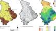
During fieldwork, we found that the flood damaged 19% of the 538 archaeological sites surveyed. The majority of damaged sites are relatively recent, dating from the medieval or modern periods, and are associated with the use of water power. Damage was mainly caused by erosion, floating debris and washout, e.g. mortar. In a case study, we tested the option of comparing pre- and post-disaster Airborne Laser Scanning elevation data to identify damages. It showed that not only the damage detected during fieldwork was found but also additional areas of loss. In general, however, and quantified based on the entire dataset, the ordnance survey Airborne Laser Scanning data were of limited use for monitoring flood-related damage and could not replace fieldwork. Our statistical analysis of possible risk factors, including both site characteristics and geospatial parameters, using Naïve Bayes Modelling and chi-squared tests, showed that no set of parameters could consistently predict the preservation or damage of archaeological sites across all catchments. In contrast, some external geospatial factors correlated with the occurrence of damage.
Conclusions
The study highlights both the strengths and limitations of the approaches used to assess and predict the damage to the archaeological heritage in the 2021 flood zones of the Rhineland. It also demonstrates the complexity of the data and spatial processes involved, which limits generalisation but can still inform decision-making for archaeological site management and on-site protection measures in flood-prone areas. With the prospect of more frequent heavy rainfall due to climate change, the specific needs of the archaeological heritage should be integrated into broader prevention and disaster management plans.
期刊介绍:
ESEU is an international journal, focusing primarily on Europe, with a broad scope covering all aspects of environmental sciences, including the main topic regulation.
ESEU will discuss the entanglement between environmental sciences and regulation because, in recent years, there have been misunderstandings and even disagreement between stakeholders in these two areas. ESEU will help to improve the comprehension of issues between environmental sciences and regulation.
ESEU will be an outlet from the German-speaking (DACH) countries to Europe and an inlet from Europe to the DACH countries regarding environmental sciences and regulation.
Moreover, ESEU will facilitate the exchange of ideas and interaction between Europe and the DACH countries regarding environmental regulatory issues.
Although Europe is at the center of ESEU, the journal will not exclude the rest of the world, because regulatory issues pertaining to environmental sciences can be fully seen only from a global perspective.
 求助内容:
求助内容: 应助结果提醒方式:


