A. J. Ashworth, A. Avila, H. Smith, T. E. Winzeler, P. Owens, C. Flynn, P. O'Brien, D. Philipp, J. Su
{"title":"利用基于系统复杂性的神经网络分析方法,从多光谱数据中预测生产力和放牧的时空模式","authors":"A. J. Ashworth, A. Avila, H. Smith, T. E. Winzeler, P. Owens, C. Flynn, P. O'Brien, D. Philipp, J. Su","doi":"10.1002/agg2.20571","DOIUrl":null,"url":null,"abstract":"<p>Remote sensing tools, along with Global Navigation Satellite System cattle collars and digital soil maps, may help elucidate spatiotemporal relationships among soils, terrain, forages, and animals. However, standard computational procedures preclude systems-level evaluations across this continuum due to data inoperability and processing limitations. Deep learning, a subset of neural network, may elucidate efficiency of livestock production and linkages within the livestock-grazing environment. Consequently, we applied deep learning to environmental remote sensing data to (1) develop predictive models for yield and forage nutrition based on vegetation indices and (2) at a pixel-level (per 55 m<sup>2</sup>), identify how grazing is linked to soil properties, forage growth and nutrition, and terrain attributes in silvopasture and pasture-only systems. Remotely sensed data rapidly and non-destructively estimated herbage mass and nutritive value for enhanced net and primary productivity management in livestock and grazing systems. Cattle grazed big bluestem (<i>Andropogon gerardii</i> ‘Vitman’) with 182% greater frequency than orchardgrass (<i>Dactylis glomerata</i> L.) in the pasture-only system. Real-time estimates of vegetative bands may assist in predicting grazing pressure for more efficient pasture resource management. Cattle grazing followed distinct soil-landscape patterns, namely reduced cattle grazing preference occurred in areas of water accumulation, which highlights linkages among terrain, soil-water movement, soil properties, forage nutrition, and animal grazing response spatially and temporally. Results from this study could be scaled up to improve grazing management among the largest land-use category in the United States, that is, grasslands, which would allow for sustainable intensification of forage-based livestock production to meet growing demands for environmentally responsible protein.</p>","PeriodicalId":7567,"journal":{"name":"Agrosystems, Geosciences & Environment","volume":"7 3","pages":""},"PeriodicalIF":1.3000,"publicationDate":"2024-09-13","publicationTypes":"Journal Article","fieldsOfStudy":null,"isOpenAccess":false,"openAccessPdf":"https://onlinelibrary.wiley.com/doi/epdf/10.1002/agg2.20571","citationCount":"0","resultStr":"{\"title\":\"Predicting spatiotemporal patterns of productivity and grazing from multispectral data using neural network analysis based on system complexity\",\"authors\":\"A. J. Ashworth, A. Avila, H. Smith, T. E. Winzeler, P. Owens, C. Flynn, P. O'Brien, D. Philipp, J. Su\",\"doi\":\"10.1002/agg2.20571\",\"DOIUrl\":null,\"url\":null,\"abstract\":\"<p>Remote sensing tools, along with Global Navigation Satellite System cattle collars and digital soil maps, may help elucidate spatiotemporal relationships among soils, terrain, forages, and animals. However, standard computational procedures preclude systems-level evaluations across this continuum due to data inoperability and processing limitations. Deep learning, a subset of neural network, may elucidate efficiency of livestock production and linkages within the livestock-grazing environment. Consequently, we applied deep learning to environmental remote sensing data to (1) develop predictive models for yield and forage nutrition based on vegetation indices and (2) at a pixel-level (per 55 m<sup>2</sup>), identify how grazing is linked to soil properties, forage growth and nutrition, and terrain attributes in silvopasture and pasture-only systems. Remotely sensed data rapidly and non-destructively estimated herbage mass and nutritive value for enhanced net and primary productivity management in livestock and grazing systems. Cattle grazed big bluestem (<i>Andropogon gerardii</i> ‘Vitman’) with 182% greater frequency than orchardgrass (<i>Dactylis glomerata</i> L.) in the pasture-only system. Real-time estimates of vegetative bands may assist in predicting grazing pressure for more efficient pasture resource management. Cattle grazing followed distinct soil-landscape patterns, namely reduced cattle grazing preference occurred in areas of water accumulation, which highlights linkages among terrain, soil-water movement, soil properties, forage nutrition, and animal grazing response spatially and temporally. Results from this study could be scaled up to improve grazing management among the largest land-use category in the United States, that is, grasslands, which would allow for sustainable intensification of forage-based livestock production to meet growing demands for environmentally responsible protein.</p>\",\"PeriodicalId\":7567,\"journal\":{\"name\":\"Agrosystems, Geosciences & Environment\",\"volume\":\"7 3\",\"pages\":\"\"},\"PeriodicalIF\":1.3000,\"publicationDate\":\"2024-09-13\",\"publicationTypes\":\"Journal Article\",\"fieldsOfStudy\":null,\"isOpenAccess\":false,\"openAccessPdf\":\"https://onlinelibrary.wiley.com/doi/epdf/10.1002/agg2.20571\",\"citationCount\":\"0\",\"resultStr\":null,\"platform\":\"Semanticscholar\",\"paperid\":null,\"PeriodicalName\":\"Agrosystems, Geosciences & Environment\",\"FirstCategoryId\":\"1085\",\"ListUrlMain\":\"https://onlinelibrary.wiley.com/doi/10.1002/agg2.20571\",\"RegionNum\":0,\"RegionCategory\":null,\"ArticlePicture\":[],\"TitleCN\":null,\"AbstractTextCN\":null,\"PMCID\":null,\"EPubDate\":\"\",\"PubModel\":\"\",\"JCR\":\"Q3\",\"JCRName\":\"AGRONOMY\",\"Score\":null,\"Total\":0}","platform":"Semanticscholar","paperid":null,"PeriodicalName":"Agrosystems, Geosciences & Environment","FirstCategoryId":"1085","ListUrlMain":"https://onlinelibrary.wiley.com/doi/10.1002/agg2.20571","RegionNum":0,"RegionCategory":null,"ArticlePicture":[],"TitleCN":null,"AbstractTextCN":null,"PMCID":null,"EPubDate":"","PubModel":"","JCR":"Q3","JCRName":"AGRONOMY","Score":null,"Total":0}
Predicting spatiotemporal patterns of productivity and grazing from multispectral data using neural network analysis based on system complexity
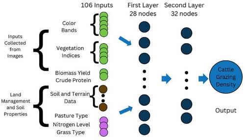
Remote sensing tools, along with Global Navigation Satellite System cattle collars and digital soil maps, may help elucidate spatiotemporal relationships among soils, terrain, forages, and animals. However, standard computational procedures preclude systems-level evaluations across this continuum due to data inoperability and processing limitations. Deep learning, a subset of neural network, may elucidate efficiency of livestock production and linkages within the livestock-grazing environment. Consequently, we applied deep learning to environmental remote sensing data to (1) develop predictive models for yield and forage nutrition based on vegetation indices and (2) at a pixel-level (per 55 m2), identify how grazing is linked to soil properties, forage growth and nutrition, and terrain attributes in silvopasture and pasture-only systems. Remotely sensed data rapidly and non-destructively estimated herbage mass and nutritive value for enhanced net and primary productivity management in livestock and grazing systems. Cattle grazed big bluestem (Andropogon gerardii ‘Vitman’) with 182% greater frequency than orchardgrass (Dactylis glomerata L.) in the pasture-only system. Real-time estimates of vegetative bands may assist in predicting grazing pressure for more efficient pasture resource management. Cattle grazing followed distinct soil-landscape patterns, namely reduced cattle grazing preference occurred in areas of water accumulation, which highlights linkages among terrain, soil-water movement, soil properties, forage nutrition, and animal grazing response spatially and temporally. Results from this study could be scaled up to improve grazing management among the largest land-use category in the United States, that is, grasslands, which would allow for sustainable intensification of forage-based livestock production to meet growing demands for environmentally responsible protein.

 求助内容:
求助内容: 应助结果提醒方式:


