{"title":"用遥感方法描述寒冷地区流域蓄水量及其对溪流生成的影响","authors":"Alexis L. Archambault, Taufique H. Mahmood","doi":"10.1007/s13157-024-01850-3","DOIUrl":null,"url":null,"abstract":"<p>The Prairie Pothole Region (PPR) has an extremely variable climate and has pronounced impacts on wetlands as they are highly responsive to the variability in air temperature and precipitation. In recent years, the PPR has been in a novel wet climate continuum since 1993, facilitating severe flooding in the Devils Lake Basin (DLB), North Dakota– costing the US ~$1B USD. Many studies using remotely sensed imagery reported a substantial increase in the number of surface water bodies and expansion of the existing water bodies during 1988–2013 period. In addition to surface water area, the water storage of the potholes also substantially increased. However, very few studies quantify the surface water storage and its dynamics to the recent increase in precipitation using remotely sensed data in the PPR. In this study, we utilize high resolution LiDAR DEM and monthly global surface water data (GSWD) to estimate filled storage of each pothole in the Starkweather Coulee Basin (SCB, 700 km<sup>2</sup>)– a headwater basin draining to a terminal lake (Devils Lake). Our findings suggest that the SCB storage gradually filling up during two wet periods: 1990–1998 and 2009–2013, resulting in massive streamflow and subsequent flooding. The SBC fractional storage also exhibits a strong positive and exponential relationship with peak streamflow and annual streamflow volume indicating strong influence of wetland storage and fill-spill hydrology on the streamflow generation. The exponential relationships also point toward a threshold SCB fractional storage for generating extreme streamflow generation.</p>","PeriodicalId":23640,"journal":{"name":"Wetlands","volume":"42 1","pages":""},"PeriodicalIF":2.0000,"publicationDate":"2024-09-11","publicationTypes":"Journal Article","fieldsOfStudy":null,"isOpenAccess":false,"openAccessPdf":"","citationCount":"0","resultStr":"{\"title\":\"A Remote Sensing Approach to Characterize Cold Region Watershed Storage and its Influence on Streamflow Generation\",\"authors\":\"Alexis L. Archambault, Taufique H. Mahmood\",\"doi\":\"10.1007/s13157-024-01850-3\",\"DOIUrl\":null,\"url\":null,\"abstract\":\"<p>The Prairie Pothole Region (PPR) has an extremely variable climate and has pronounced impacts on wetlands as they are highly responsive to the variability in air temperature and precipitation. In recent years, the PPR has been in a novel wet climate continuum since 1993, facilitating severe flooding in the Devils Lake Basin (DLB), North Dakota– costing the US ~$1B USD. Many studies using remotely sensed imagery reported a substantial increase in the number of surface water bodies and expansion of the existing water bodies during 1988–2013 period. In addition to surface water area, the water storage of the potholes also substantially increased. However, very few studies quantify the surface water storage and its dynamics to the recent increase in precipitation using remotely sensed data in the PPR. In this study, we utilize high resolution LiDAR DEM and monthly global surface water data (GSWD) to estimate filled storage of each pothole in the Starkweather Coulee Basin (SCB, 700 km<sup>2</sup>)– a headwater basin draining to a terminal lake (Devils Lake). Our findings suggest that the SCB storage gradually filling up during two wet periods: 1990–1998 and 2009–2013, resulting in massive streamflow and subsequent flooding. The SBC fractional storage also exhibits a strong positive and exponential relationship with peak streamflow and annual streamflow volume indicating strong influence of wetland storage and fill-spill hydrology on the streamflow generation. The exponential relationships also point toward a threshold SCB fractional storage for generating extreme streamflow generation.</p>\",\"PeriodicalId\":23640,\"journal\":{\"name\":\"Wetlands\",\"volume\":\"42 1\",\"pages\":\"\"},\"PeriodicalIF\":2.0000,\"publicationDate\":\"2024-09-11\",\"publicationTypes\":\"Journal Article\",\"fieldsOfStudy\":null,\"isOpenAccess\":false,\"openAccessPdf\":\"\",\"citationCount\":\"0\",\"resultStr\":null,\"platform\":\"Semanticscholar\",\"paperid\":null,\"PeriodicalName\":\"Wetlands\",\"FirstCategoryId\":\"93\",\"ListUrlMain\":\"https://doi.org/10.1007/s13157-024-01850-3\",\"RegionNum\":4,\"RegionCategory\":\"环境科学与生态学\",\"ArticlePicture\":[],\"TitleCN\":null,\"AbstractTextCN\":null,\"PMCID\":null,\"EPubDate\":\"\",\"PubModel\":\"\",\"JCR\":\"Q3\",\"JCRName\":\"ECOLOGY\",\"Score\":null,\"Total\":0}","platform":"Semanticscholar","paperid":null,"PeriodicalName":"Wetlands","FirstCategoryId":"93","ListUrlMain":"https://doi.org/10.1007/s13157-024-01850-3","RegionNum":4,"RegionCategory":"环境科学与生态学","ArticlePicture":[],"TitleCN":null,"AbstractTextCN":null,"PMCID":null,"EPubDate":"","PubModel":"","JCR":"Q3","JCRName":"ECOLOGY","Score":null,"Total":0}
A Remote Sensing Approach to Characterize Cold Region Watershed Storage and its Influence on Streamflow Generation
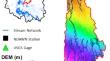
The Prairie Pothole Region (PPR) has an extremely variable climate and has pronounced impacts on wetlands as they are highly responsive to the variability in air temperature and precipitation. In recent years, the PPR has been in a novel wet climate continuum since 1993, facilitating severe flooding in the Devils Lake Basin (DLB), North Dakota– costing the US ~$1B USD. Many studies using remotely sensed imagery reported a substantial increase in the number of surface water bodies and expansion of the existing water bodies during 1988–2013 period. In addition to surface water area, the water storage of the potholes also substantially increased. However, very few studies quantify the surface water storage and its dynamics to the recent increase in precipitation using remotely sensed data in the PPR. In this study, we utilize high resolution LiDAR DEM and monthly global surface water data (GSWD) to estimate filled storage of each pothole in the Starkweather Coulee Basin (SCB, 700 km2)– a headwater basin draining to a terminal lake (Devils Lake). Our findings suggest that the SCB storage gradually filling up during two wet periods: 1990–1998 and 2009–2013, resulting in massive streamflow and subsequent flooding. The SBC fractional storage also exhibits a strong positive and exponential relationship with peak streamflow and annual streamflow volume indicating strong influence of wetland storage and fill-spill hydrology on the streamflow generation. The exponential relationships also point toward a threshold SCB fractional storage for generating extreme streamflow generation.
期刊介绍:
Wetlands is an international journal concerned with all aspects of wetlands biology, ecology, hydrology, water chemistry, soil and sediment characteristics, management, and laws and regulations. The journal is published 6 times per year, with the goal of centralizing the publication of pioneering wetlands work that has otherwise been spread among a myriad of journals. Since wetlands research usually requires an interdisciplinary approach, the journal in not limited to specific disciplines but seeks manuscripts reporting research results from all relevant disciplines. Manuscripts focusing on management topics and regulatory considerations relevant to wetlands are also suitable. Submissions may be in the form of articles or short notes. Timely review articles will also be considered, but the subject and content should be discussed with the Editor-in-Chief (NDSU.wetlands.editor@ndsu.edu) prior to submission. All papers published in Wetlands are reviewed by two qualified peers, an Associate Editor, and the Editor-in-Chief prior to acceptance and publication. All papers must present new information, must be factual and original, and must not have been published elsewhere.
 求助内容:
求助内容: 应助结果提醒方式:


