T. Curk, J. Melzheimer, O. Aschenborn, A. Amar, H. Kolberg, R. Garbett, G. Maude, R. P. Reading, M. Selebatso, F. Berzaghi, G. P. Hempson, A. Botha, R. L. Thomson, G. Tate, O. Spiegel, A. Santangeli
{"title":"整合威胁测绘和动物移动数据,确定濒危移动物种的高风险区域","authors":"T. Curk, J. Melzheimer, O. Aschenborn, A. Amar, H. Kolberg, R. Garbett, G. Maude, R. P. Reading, M. Selebatso, F. Berzaghi, G. P. Hempson, A. Botha, R. L. Thomson, G. Tate, O. Spiegel, A. Santangeli","doi":"10.1111/acv.12980","DOIUrl":null,"url":null,"abstract":"<p>Given the current biodiversity crisis, understanding how animals move across a landscape dotted with different anthropogenic threats and the consequences of those threats for animals is paramount to devising evidence-based conservation interventions. Vultures roam across large areas and are highly exposed to poisoning, which represents a particularly damaging form of wildlife crime. In this study, we introduce a framework for quantifying the exposure to threats and illustrate an example of poisoning risk as a threat in an endangered African vulture species, the Lappet-faced Vulture (<i>Torgos tracheliotos</i>). We combined GPS tracking data of 19 individuals collected between 2012 and 2022 with food availability and spatial threat maps of both intentional (poachers directly targeting vultures) and unintentional (farmers aiming to kill carnivores, with vultures being secondarily affected) poisoning across most of Southern Africa. We identified poisoning hotspots in northern Botswana and south-eastern Namibia. These areas were also associated with a high number of vulture mortalities, providing additional support for poisoning risk. Northern Botswana and areas at the border between Botswana and South Africa were characterized by high food availability, potentially amplifying the mortality rate by attracting vultures from surrounding areas. Our results offer valuable insights for regional vulture conservation, together with a methodological framework for quantifying and mapping the spatial exposure to threats for mobile species of conservation concern, enabling improved targeting of conservation actions.</p>","PeriodicalId":50786,"journal":{"name":"Animal Conservation","volume":"28 2","pages":"291-302"},"PeriodicalIF":2.6000,"publicationDate":"2024-08-19","publicationTypes":"Journal Article","fieldsOfStudy":null,"isOpenAccess":false,"openAccessPdf":"https://onlinelibrary.wiley.com/doi/epdf/10.1111/acv.12980","citationCount":"0","resultStr":"{\"title\":\"Integrating threat mapping and animal movement data to identify high-risk areas for endangered mobile species\",\"authors\":\"T. Curk, J. Melzheimer, O. Aschenborn, A. Amar, H. Kolberg, R. Garbett, G. Maude, R. P. Reading, M. Selebatso, F. Berzaghi, G. P. Hempson, A. Botha, R. L. Thomson, G. Tate, O. Spiegel, A. Santangeli\",\"doi\":\"10.1111/acv.12980\",\"DOIUrl\":null,\"url\":null,\"abstract\":\"<p>Given the current biodiversity crisis, understanding how animals move across a landscape dotted with different anthropogenic threats and the consequences of those threats for animals is paramount to devising evidence-based conservation interventions. Vultures roam across large areas and are highly exposed to poisoning, which represents a particularly damaging form of wildlife crime. In this study, we introduce a framework for quantifying the exposure to threats and illustrate an example of poisoning risk as a threat in an endangered African vulture species, the Lappet-faced Vulture (<i>Torgos tracheliotos</i>). We combined GPS tracking data of 19 individuals collected between 2012 and 2022 with food availability and spatial threat maps of both intentional (poachers directly targeting vultures) and unintentional (farmers aiming to kill carnivores, with vultures being secondarily affected) poisoning across most of Southern Africa. We identified poisoning hotspots in northern Botswana and south-eastern Namibia. These areas were also associated with a high number of vulture mortalities, providing additional support for poisoning risk. Northern Botswana and areas at the border between Botswana and South Africa were characterized by high food availability, potentially amplifying the mortality rate by attracting vultures from surrounding areas. Our results offer valuable insights for regional vulture conservation, together with a methodological framework for quantifying and mapping the spatial exposure to threats for mobile species of conservation concern, enabling improved targeting of conservation actions.</p>\",\"PeriodicalId\":50786,\"journal\":{\"name\":\"Animal Conservation\",\"volume\":\"28 2\",\"pages\":\"291-302\"},\"PeriodicalIF\":2.6000,\"publicationDate\":\"2024-08-19\",\"publicationTypes\":\"Journal Article\",\"fieldsOfStudy\":null,\"isOpenAccess\":false,\"openAccessPdf\":\"https://onlinelibrary.wiley.com/doi/epdf/10.1111/acv.12980\",\"citationCount\":\"0\",\"resultStr\":null,\"platform\":\"Semanticscholar\",\"paperid\":null,\"PeriodicalName\":\"Animal Conservation\",\"FirstCategoryId\":\"93\",\"ListUrlMain\":\"https://zslpublications.onlinelibrary.wiley.com/doi/10.1111/acv.12980\",\"RegionNum\":2,\"RegionCategory\":\"环境科学与生态学\",\"ArticlePicture\":[],\"TitleCN\":null,\"AbstractTextCN\":null,\"PMCID\":null,\"EPubDate\":\"\",\"PubModel\":\"\",\"JCR\":\"Q1\",\"JCRName\":\"BIODIVERSITY CONSERVATION\",\"Score\":null,\"Total\":0}","platform":"Semanticscholar","paperid":null,"PeriodicalName":"Animal Conservation","FirstCategoryId":"93","ListUrlMain":"https://zslpublications.onlinelibrary.wiley.com/doi/10.1111/acv.12980","RegionNum":2,"RegionCategory":"环境科学与生态学","ArticlePicture":[],"TitleCN":null,"AbstractTextCN":null,"PMCID":null,"EPubDate":"","PubModel":"","JCR":"Q1","JCRName":"BIODIVERSITY CONSERVATION","Score":null,"Total":0}
Integrating threat mapping and animal movement data to identify high-risk areas for endangered mobile species
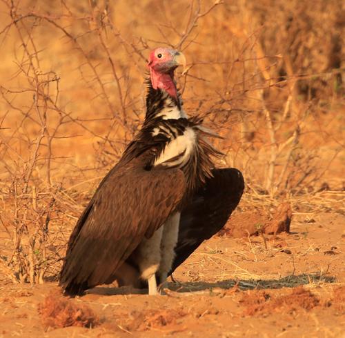
Given the current biodiversity crisis, understanding how animals move across a landscape dotted with different anthropogenic threats and the consequences of those threats for animals is paramount to devising evidence-based conservation interventions. Vultures roam across large areas and are highly exposed to poisoning, which represents a particularly damaging form of wildlife crime. In this study, we introduce a framework for quantifying the exposure to threats and illustrate an example of poisoning risk as a threat in an endangered African vulture species, the Lappet-faced Vulture (Torgos tracheliotos). We combined GPS tracking data of 19 individuals collected between 2012 and 2022 with food availability and spatial threat maps of both intentional (poachers directly targeting vultures) and unintentional (farmers aiming to kill carnivores, with vultures being secondarily affected) poisoning across most of Southern Africa. We identified poisoning hotspots in northern Botswana and south-eastern Namibia. These areas were also associated with a high number of vulture mortalities, providing additional support for poisoning risk. Northern Botswana and areas at the border between Botswana and South Africa were characterized by high food availability, potentially amplifying the mortality rate by attracting vultures from surrounding areas. Our results offer valuable insights for regional vulture conservation, together with a methodological framework for quantifying and mapping the spatial exposure to threats for mobile species of conservation concern, enabling improved targeting of conservation actions.
期刊介绍:
Animal Conservation provides a forum for rapid publication of novel, peer-reviewed research into the conservation of animal species and their habitats. The focus is on rigorous quantitative studies of an empirical or theoretical nature, which may relate to populations, species or communities and their conservation. We encourage the submission of single-species papers that have clear broader implications for conservation of other species or systems. A central theme is to publish important new ideas of broad interest and with findings that advance the scientific basis of conservation. Subjects covered include population biology, epidemiology, evolutionary ecology, population genetics, biodiversity, biogeography, palaeobiology and conservation economics.


 求助内容:
求助内容: 应助结果提醒方式:


