Kris L. Laferriere, Ali M. Bramson, Isaac B. Smith
{"title":"三维雷达测绘揭示的火星北极螺旋槽迁移路径","authors":"Kris L. Laferriere, Ali M. Bramson, Isaac B. Smith","doi":"10.1029/2023JE007996","DOIUrl":null,"url":null,"abstract":"<p>We present observations and maps of Mars' northern polar spiral trough migration paths (TMPs) as revealed through the 3D SHARAD (Shallow Radar) data volume, identify patterns of TMP morphology, and provide interpretations and implications of these TMPs on past climate. This data set provides additional spatial context over traditional 2D data as it allows for radargrams to be taken perpendicular to each trough strike, which minimizes distortion of migration paths due to oblique viewing geometry. Here, we present an expanded survey of trough migration and analysis of surface troughs across the north polar layered deposits. We corroborate many previous observations of trough migration such as: the general poleward and stratigraphically upward migration from the TMP initiation point; the broadly similar depth of trough initiation across the cap; regional variability in TMP morphology; and the presence of buried promontories. Our results support the presence of two generations of troughs, though we cannot confirm that the oldest generation originated deeper than ∼600 m beneath the current surface, as previously reported. Two generations of troughs suggest that climate conditions favorable for initiation of trough migration have occurred at least twice. Trough initiation occurring only in the upper ∼600 m suggests that troughs are relatively recent features in the polar cap, developing after the formation of ∼half the current cap height. The mapped TMPs provide insight into the consistency of Mars' climate during the accumulation of the past few hundred meters of ice by recording the boundary of erosion and accumulation of ice at the troughs.</p>","PeriodicalId":16101,"journal":{"name":"Journal of Geophysical Research: Planets","volume":"129 8","pages":""},"PeriodicalIF":3.9000,"publicationDate":"2024-08-12","publicationTypes":"Journal Article","fieldsOfStudy":null,"isOpenAccess":false,"openAccessPdf":"https://onlinelibrary.wiley.com/doi/epdf/10.1029/2023JE007996","citationCount":"0","resultStr":"{\"title\":\"Mars' North Polar Spiral Trough Migration Paths as Revealed Through 3D Radar Mapping\",\"authors\":\"Kris L. Laferriere, Ali M. Bramson, Isaac B. Smith\",\"doi\":\"10.1029/2023JE007996\",\"DOIUrl\":null,\"url\":null,\"abstract\":\"<p>We present observations and maps of Mars' northern polar spiral trough migration paths (TMPs) as revealed through the 3D SHARAD (Shallow Radar) data volume, identify patterns of TMP morphology, and provide interpretations and implications of these TMPs on past climate. This data set provides additional spatial context over traditional 2D data as it allows for radargrams to be taken perpendicular to each trough strike, which minimizes distortion of migration paths due to oblique viewing geometry. Here, we present an expanded survey of trough migration and analysis of surface troughs across the north polar layered deposits. We corroborate many previous observations of trough migration such as: the general poleward and stratigraphically upward migration from the TMP initiation point; the broadly similar depth of trough initiation across the cap; regional variability in TMP morphology; and the presence of buried promontories. Our results support the presence of two generations of troughs, though we cannot confirm that the oldest generation originated deeper than ∼600 m beneath the current surface, as previously reported. Two generations of troughs suggest that climate conditions favorable for initiation of trough migration have occurred at least twice. Trough initiation occurring only in the upper ∼600 m suggests that troughs are relatively recent features in the polar cap, developing after the formation of ∼half the current cap height. The mapped TMPs provide insight into the consistency of Mars' climate during the accumulation of the past few hundred meters of ice by recording the boundary of erosion and accumulation of ice at the troughs.</p>\",\"PeriodicalId\":16101,\"journal\":{\"name\":\"Journal of Geophysical Research: Planets\",\"volume\":\"129 8\",\"pages\":\"\"},\"PeriodicalIF\":3.9000,\"publicationDate\":\"2024-08-12\",\"publicationTypes\":\"Journal Article\",\"fieldsOfStudy\":null,\"isOpenAccess\":false,\"openAccessPdf\":\"https://onlinelibrary.wiley.com/doi/epdf/10.1029/2023JE007996\",\"citationCount\":\"0\",\"resultStr\":null,\"platform\":\"Semanticscholar\",\"paperid\":null,\"PeriodicalName\":\"Journal of Geophysical Research: Planets\",\"FirstCategoryId\":\"89\",\"ListUrlMain\":\"https://onlinelibrary.wiley.com/doi/10.1029/2023JE007996\",\"RegionNum\":1,\"RegionCategory\":\"地球科学\",\"ArticlePicture\":[],\"TitleCN\":null,\"AbstractTextCN\":null,\"PMCID\":null,\"EPubDate\":\"\",\"PubModel\":\"\",\"JCR\":\"Q1\",\"JCRName\":\"GEOCHEMISTRY & GEOPHYSICS\",\"Score\":null,\"Total\":0}","platform":"Semanticscholar","paperid":null,"PeriodicalName":"Journal of Geophysical Research: Planets","FirstCategoryId":"89","ListUrlMain":"https://onlinelibrary.wiley.com/doi/10.1029/2023JE007996","RegionNum":1,"RegionCategory":"地球科学","ArticlePicture":[],"TitleCN":null,"AbstractTextCN":null,"PMCID":null,"EPubDate":"","PubModel":"","JCR":"Q1","JCRName":"GEOCHEMISTRY & GEOPHYSICS","Score":null,"Total":0}
Mars' North Polar Spiral Trough Migration Paths as Revealed Through 3D Radar Mapping
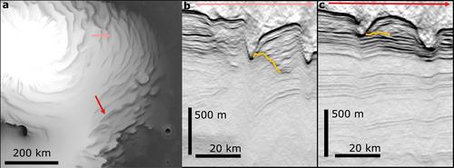
We present observations and maps of Mars' northern polar spiral trough migration paths (TMPs) as revealed through the 3D SHARAD (Shallow Radar) data volume, identify patterns of TMP morphology, and provide interpretations and implications of these TMPs on past climate. This data set provides additional spatial context over traditional 2D data as it allows for radargrams to be taken perpendicular to each trough strike, which minimizes distortion of migration paths due to oblique viewing geometry. Here, we present an expanded survey of trough migration and analysis of surface troughs across the north polar layered deposits. We corroborate many previous observations of trough migration such as: the general poleward and stratigraphically upward migration from the TMP initiation point; the broadly similar depth of trough initiation across the cap; regional variability in TMP morphology; and the presence of buried promontories. Our results support the presence of two generations of troughs, though we cannot confirm that the oldest generation originated deeper than ∼600 m beneath the current surface, as previously reported. Two generations of troughs suggest that climate conditions favorable for initiation of trough migration have occurred at least twice. Trough initiation occurring only in the upper ∼600 m suggests that troughs are relatively recent features in the polar cap, developing after the formation of ∼half the current cap height. The mapped TMPs provide insight into the consistency of Mars' climate during the accumulation of the past few hundred meters of ice by recording the boundary of erosion and accumulation of ice at the troughs.
期刊介绍:
The Journal of Geophysical Research Planets is dedicated to the publication of new and original research in the broad field of planetary science. Manuscripts concerning planetary geology, geophysics, geochemistry, atmospheres, and dynamics are appropriate for the journal when they increase knowledge about the processes that affect Solar System objects. Manuscripts concerning other planetary systems, exoplanets or Earth are welcome when presented in a comparative planetology perspective. Studies in the field of astrobiology will be considered when they have immediate consequences for the interpretation of planetary data. JGR: Planets does not publish manuscripts that deal with future missions and instrumentation, nor those that are primarily of an engineering interest. Instrument, calibration or data processing papers may be appropriate for the journal, but only when accompanied by scientific analysis and interpretation that increases understanding of the studied object. A manuscript that describes a new method or technique would be acceptable for JGR: Planets if it contained new and relevant scientific results obtained using the method. Review articles are generally not appropriate for JGR: Planets, but they may be considered if they form an integral part of a special issue.
 求助内容:
求助内容: 应助结果提醒方式:


