Maryam Moshgelgosha, Ahmad Zamani, Vahid Ahmadi, Kouros Yazdjerdi
{"title":"中新世矿床基底断层综合分析:法尔斯和阿巴斯港的视角","authors":"Maryam Moshgelgosha, Ahmad Zamani, Vahid Ahmadi, Kouros Yazdjerdi","doi":"10.1134/s1028334x24601536","DOIUrl":null,"url":null,"abstract":"<h3 data-test=\"abstract-sub-heading\">Abstract</h3><p>The Zagros Fold and Thrust Belt (ZFB) in southwestern Iran emerges as a geological marvel, defined by series of compact anticlines and synclines that the NW–SE trending structures of the Zagros belt. This unique configuration designates the ZFB as the dynamic boundary of the Arabian platform, shaped by the forces of nature. Over time, sedimentation in the expansive basin led to a gradual transformation, with folds originally oriented differently nowfolds axial line inclining southwestward, revealing a progressive shift in fold axial planes. This article presents a pioneering tectono-stratigraphic examination of Miocene Formations in the Fars and Bandar Abbas Hinterland, Southern Iran. The study meticulously explores five locations—Bastak, Taghdis-e Bahar, Dasht-e Arzhan, Saedi Mountain, and Yasuj—analyzing stratigraphic sections of the Miocene Formation. The Isopach map exposes variations in Miocene Formation thicknesses across these sites. In the Arjan plain, significant facies change unfolds, transitioning from Gachsaran Formation’s evaporitic sedimentary rocks to Rzak Formation’s marine sedimentary rocks and Asmari Formation’s calcareous rocks along a northwest–southwest border. These facies change correlates intricately with subtle movements of fault zones—Kareh–Bas, Sabzpooshan, Sarvestan, and Kazerun. The tectono-stratigraphic journey unveils a profound connection between changes in sedimentary basin depth and nuanced alterations in sedimentary rocks’ facies, orchestrated by the interplay of various basement faults, some following the Arabian trend, others aligning with the majestic Zagros trend—a symphony of geological forces shaping the Miocene narrative in the Fars and Bandar Abbas Hinterland.</p>","PeriodicalId":11352,"journal":{"name":"Doklady Earth Sciences","volume":"56 1","pages":""},"PeriodicalIF":0.7000,"publicationDate":"2024-08-11","publicationTypes":"Journal Article","fieldsOfStudy":null,"isOpenAccess":false,"openAccessPdf":"","citationCount":"0","resultStr":"{\"title\":\"A Comprehensive Analysis of Basement Faults in Miocene Deposits: Fars and Bandar Abbas Perspectives\",\"authors\":\"Maryam Moshgelgosha, Ahmad Zamani, Vahid Ahmadi, Kouros Yazdjerdi\",\"doi\":\"10.1134/s1028334x24601536\",\"DOIUrl\":null,\"url\":null,\"abstract\":\"<h3 data-test=\\\"abstract-sub-heading\\\">Abstract</h3><p>The Zagros Fold and Thrust Belt (ZFB) in southwestern Iran emerges as a geological marvel, defined by series of compact anticlines and synclines that the NW–SE trending structures of the Zagros belt. This unique configuration designates the ZFB as the dynamic boundary of the Arabian platform, shaped by the forces of nature. Over time, sedimentation in the expansive basin led to a gradual transformation, with folds originally oriented differently nowfolds axial line inclining southwestward, revealing a progressive shift in fold axial planes. This article presents a pioneering tectono-stratigraphic examination of Miocene Formations in the Fars and Bandar Abbas Hinterland, Southern Iran. The study meticulously explores five locations—Bastak, Taghdis-e Bahar, Dasht-e Arzhan, Saedi Mountain, and Yasuj—analyzing stratigraphic sections of the Miocene Formation. The Isopach map exposes variations in Miocene Formation thicknesses across these sites. In the Arjan plain, significant facies change unfolds, transitioning from Gachsaran Formation’s evaporitic sedimentary rocks to Rzak Formation’s marine sedimentary rocks and Asmari Formation’s calcareous rocks along a northwest–southwest border. These facies change correlates intricately with subtle movements of fault zones—Kareh–Bas, Sabzpooshan, Sarvestan, and Kazerun. The tectono-stratigraphic journey unveils a profound connection between changes in sedimentary basin depth and nuanced alterations in sedimentary rocks’ facies, orchestrated by the interplay of various basement faults, some following the Arabian trend, others aligning with the majestic Zagros trend—a symphony of geological forces shaping the Miocene narrative in the Fars and Bandar Abbas Hinterland.</p>\",\"PeriodicalId\":11352,\"journal\":{\"name\":\"Doklady Earth Sciences\",\"volume\":\"56 1\",\"pages\":\"\"},\"PeriodicalIF\":0.7000,\"publicationDate\":\"2024-08-11\",\"publicationTypes\":\"Journal Article\",\"fieldsOfStudy\":null,\"isOpenAccess\":false,\"openAccessPdf\":\"\",\"citationCount\":\"0\",\"resultStr\":null,\"platform\":\"Semanticscholar\",\"paperid\":null,\"PeriodicalName\":\"Doklady Earth Sciences\",\"FirstCategoryId\":\"89\",\"ListUrlMain\":\"https://doi.org/10.1134/s1028334x24601536\",\"RegionNum\":4,\"RegionCategory\":\"地球科学\",\"ArticlePicture\":[],\"TitleCN\":null,\"AbstractTextCN\":null,\"PMCID\":null,\"EPubDate\":\"\",\"PubModel\":\"\",\"JCR\":\"Q4\",\"JCRName\":\"GEOSCIENCES, MULTIDISCIPLINARY\",\"Score\":null,\"Total\":0}","platform":"Semanticscholar","paperid":null,"PeriodicalName":"Doklady Earth Sciences","FirstCategoryId":"89","ListUrlMain":"https://doi.org/10.1134/s1028334x24601536","RegionNum":4,"RegionCategory":"地球科学","ArticlePicture":[],"TitleCN":null,"AbstractTextCN":null,"PMCID":null,"EPubDate":"","PubModel":"","JCR":"Q4","JCRName":"GEOSCIENCES, MULTIDISCIPLINARY","Score":null,"Total":0}
A Comprehensive Analysis of Basement Faults in Miocene Deposits: Fars and Bandar Abbas Perspectives
Abstract
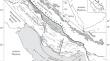
The Zagros Fold and Thrust Belt (ZFB) in southwestern Iran emerges as a geological marvel, defined by series of compact anticlines and synclines that the NW–SE trending structures of the Zagros belt. This unique configuration designates the ZFB as the dynamic boundary of the Arabian platform, shaped by the forces of nature. Over time, sedimentation in the expansive basin led to a gradual transformation, with folds originally oriented differently nowfolds axial line inclining southwestward, revealing a progressive shift in fold axial planes. This article presents a pioneering tectono-stratigraphic examination of Miocene Formations in the Fars and Bandar Abbas Hinterland, Southern Iran. The study meticulously explores five locations—Bastak, Taghdis-e Bahar, Dasht-e Arzhan, Saedi Mountain, and Yasuj—analyzing stratigraphic sections of the Miocene Formation. The Isopach map exposes variations in Miocene Formation thicknesses across these sites. In the Arjan plain, significant facies change unfolds, transitioning from Gachsaran Formation’s evaporitic sedimentary rocks to Rzak Formation’s marine sedimentary rocks and Asmari Formation’s calcareous rocks along a northwest–southwest border. These facies change correlates intricately with subtle movements of fault zones—Kareh–Bas, Sabzpooshan, Sarvestan, and Kazerun. The tectono-stratigraphic journey unveils a profound connection between changes in sedimentary basin depth and nuanced alterations in sedimentary rocks’ facies, orchestrated by the interplay of various basement faults, some following the Arabian trend, others aligning with the majestic Zagros trend—a symphony of geological forces shaping the Miocene narrative in the Fars and Bandar Abbas Hinterland.
期刊介绍:
Doklady Earth Sciences is a journal that publishes new research in Earth science of great significance. Initially the journal was a forum of the Russian Academy of Science and published only best contributions from Russia. Now the journal welcomes submissions from any country in the English or Russian language. Every manuscript must be recommended by Russian or foreign members of the Russian Academy of Sciences.
 求助内容:
求助内容: 应助结果提醒方式:


