Madiha Asif, Muhammad Yaseen, Syed Umair Shahid, Yasir Latif, Salma Anwar, Sohail Abbas
{"title":"巴基斯坦高海拔吉尔吉特河流域可能的雨水收集地点的地理空间识别","authors":"Madiha Asif, Muhammad Yaseen, Syed Umair Shahid, Yasir Latif, Salma Anwar, Sohail Abbas","doi":"10.1007/s00704-024-05024-3","DOIUrl":null,"url":null,"abstract":"<p>The management of water resources is no longer an option but a necessity especially in countries with a high rate of population growth like Pakistan. Pakistan has a high-water scarcity, an extremely varying topography, and is also one of the countries encountering the problem of climate change. Therefore, prudent utilization of available water resources is a matter in the plains of Pakistan as in its high-altitude regions. Instead of wasting water which is a valuable resource, rainwater harvesting is a way of saving rainwater as an alternative source of fresh water for better use. The aim of this study was to search for potential rainwater-harvesting areas in a high-altitude Gilgit River basin. This research employed the SCS-CN technique in estimating surface runoff in the GIS environment. The geospatial study used four input parameters: slope of the land, land covers, surface runoff and drainage density. The research concluded that some lands, especially those that are deserted in dry area and agricultural lands, can serve as the sites of rainwater harvesting, with only 4% of area that was highly suitable for the purpose. Nevertheless, 37% of the investigated area was shown as totally unviable for rainwater collection installations because of steep slopes and substantial volume of snow. Simultaneously, the rainwater storage design solutions suggested were check dam, percolation tank, and agricultural ponds with the area of 3.5%, 1%, and 0.75% of the given land area, respectively, for rainwater harvesting. The locations of potential catchment and planned rainwater harvesting structures would assist the local authorities and the policy makers to provide plans and design on the construction of water storages and also the optimization of water use.</p>","PeriodicalId":22945,"journal":{"name":"Theoretical and Applied Climatology","volume":"64 1","pages":""},"PeriodicalIF":2.7000,"publicationDate":"2024-07-18","publicationTypes":"Journal Article","fieldsOfStudy":null,"isOpenAccess":false,"openAccessPdf":"","citationCount":"0","resultStr":"{\"title\":\"Geospatial identification of possible rainwater harvesting locations within a high-altitude Gilgit River basin, Pakistan\",\"authors\":\"Madiha Asif, Muhammad Yaseen, Syed Umair Shahid, Yasir Latif, Salma Anwar, Sohail Abbas\",\"doi\":\"10.1007/s00704-024-05024-3\",\"DOIUrl\":null,\"url\":null,\"abstract\":\"<p>The management of water resources is no longer an option but a necessity especially in countries with a high rate of population growth like Pakistan. Pakistan has a high-water scarcity, an extremely varying topography, and is also one of the countries encountering the problem of climate change. Therefore, prudent utilization of available water resources is a matter in the plains of Pakistan as in its high-altitude regions. Instead of wasting water which is a valuable resource, rainwater harvesting is a way of saving rainwater as an alternative source of fresh water for better use. The aim of this study was to search for potential rainwater-harvesting areas in a high-altitude Gilgit River basin. This research employed the SCS-CN technique in estimating surface runoff in the GIS environment. The geospatial study used four input parameters: slope of the land, land covers, surface runoff and drainage density. The research concluded that some lands, especially those that are deserted in dry area and agricultural lands, can serve as the sites of rainwater harvesting, with only 4% of area that was highly suitable for the purpose. Nevertheless, 37% of the investigated area was shown as totally unviable for rainwater collection installations because of steep slopes and substantial volume of snow. Simultaneously, the rainwater storage design solutions suggested were check dam, percolation tank, and agricultural ponds with the area of 3.5%, 1%, and 0.75% of the given land area, respectively, for rainwater harvesting. The locations of potential catchment and planned rainwater harvesting structures would assist the local authorities and the policy makers to provide plans and design on the construction of water storages and also the optimization of water use.</p>\",\"PeriodicalId\":22945,\"journal\":{\"name\":\"Theoretical and Applied Climatology\",\"volume\":\"64 1\",\"pages\":\"\"},\"PeriodicalIF\":2.7000,\"publicationDate\":\"2024-07-18\",\"publicationTypes\":\"Journal Article\",\"fieldsOfStudy\":null,\"isOpenAccess\":false,\"openAccessPdf\":\"\",\"citationCount\":\"0\",\"resultStr\":null,\"platform\":\"Semanticscholar\",\"paperid\":null,\"PeriodicalName\":\"Theoretical and Applied Climatology\",\"FirstCategoryId\":\"89\",\"ListUrlMain\":\"https://doi.org/10.1007/s00704-024-05024-3\",\"RegionNum\":4,\"RegionCategory\":\"地球科学\",\"ArticlePicture\":[],\"TitleCN\":null,\"AbstractTextCN\":null,\"PMCID\":null,\"EPubDate\":\"\",\"PubModel\":\"\",\"JCR\":\"Q3\",\"JCRName\":\"METEOROLOGY & ATMOSPHERIC SCIENCES\",\"Score\":null,\"Total\":0}","platform":"Semanticscholar","paperid":null,"PeriodicalName":"Theoretical and Applied Climatology","FirstCategoryId":"89","ListUrlMain":"https://doi.org/10.1007/s00704-024-05024-3","RegionNum":4,"RegionCategory":"地球科学","ArticlePicture":[],"TitleCN":null,"AbstractTextCN":null,"PMCID":null,"EPubDate":"","PubModel":"","JCR":"Q3","JCRName":"METEOROLOGY & ATMOSPHERIC SCIENCES","Score":null,"Total":0}
Geospatial identification of possible rainwater harvesting locations within a high-altitude Gilgit River basin, Pakistan
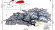
The management of water resources is no longer an option but a necessity especially in countries with a high rate of population growth like Pakistan. Pakistan has a high-water scarcity, an extremely varying topography, and is also one of the countries encountering the problem of climate change. Therefore, prudent utilization of available water resources is a matter in the plains of Pakistan as in its high-altitude regions. Instead of wasting water which is a valuable resource, rainwater harvesting is a way of saving rainwater as an alternative source of fresh water for better use. The aim of this study was to search for potential rainwater-harvesting areas in a high-altitude Gilgit River basin. This research employed the SCS-CN technique in estimating surface runoff in the GIS environment. The geospatial study used four input parameters: slope of the land, land covers, surface runoff and drainage density. The research concluded that some lands, especially those that are deserted in dry area and agricultural lands, can serve as the sites of rainwater harvesting, with only 4% of area that was highly suitable for the purpose. Nevertheless, 37% of the investigated area was shown as totally unviable for rainwater collection installations because of steep slopes and substantial volume of snow. Simultaneously, the rainwater storage design solutions suggested were check dam, percolation tank, and agricultural ponds with the area of 3.5%, 1%, and 0.75% of the given land area, respectively, for rainwater harvesting. The locations of potential catchment and planned rainwater harvesting structures would assist the local authorities and the policy makers to provide plans and design on the construction of water storages and also the optimization of water use.
期刊介绍:
Theoretical and Applied Climatology covers the following topics:
- climate modeling, climatic changes and climate forecasting, micro- to mesoclimate, applied meteorology as in agro- and forestmeteorology, biometeorology, building meteorology and atmospheric radiation problems as they relate to the biosphere
- effects of anthropogenic and natural aerosols or gaseous trace constituents
- hardware and software elements of meteorological measurements, including techniques of remote sensing
 求助内容:
求助内容: 应助结果提醒方式:


