Feleke K. Sishu , Seifu A. Tilahun , Petra Schmitter , Tammo S. Steenhuis
{"title":"重新审视用于坡地和山区基流和地下水储存预测的 Thornthwaite Mather 程序","authors":"Feleke K. Sishu , Seifu A. Tilahun , Petra Schmitter , Tammo S. Steenhuis","doi":"10.1016/j.hydroa.2024.100179","DOIUrl":null,"url":null,"abstract":"<div><p>Hillslope aquifers regulate streamflow and are a critical potable and irrigation water source, especially in developing countries. Knowing recharge and baseflow is essential for managing these aquifers. Methods using available data to calculate recharge and baseflow from aquifers are not valid for uplands. This paper adapts the Thornthwaite and Mather (T-M) procedure from plains to sloping and mountainous regions by replacing the linear reservoir with a zero-order aquifer. The revised T-M procedure was tested over four years in two contrasting watersheds in the humid Ethiopian highlands: the 57 km<sup>2</sup> Dangishta with a perennial stream and the nine km<sup>2</sup> Robit Bata, where the flow ceased four months after the end of the rain phase. The monthly average groundwater tables were predicted with an accuracy ranging from satisfactory to good for both watersheds. Baseflow predictions were “very good” after considering the evaporation from shallow groundwater in the valley bottom during the dry phase in Dangishta. We conclude that the T-M procedure is ideally suited for calculating recharge, baseflow and groundwater storage in upland regions with sparse hydrological data since the procedure uses as input only rainfall and potential evaporation data that are readily available together with an estimate of the aquifer travel time.</p></div>","PeriodicalId":36948,"journal":{"name":"Journal of Hydrology X","volume":"24 ","pages":"Article 100179"},"PeriodicalIF":3.1000,"publicationDate":"2024-04-26","publicationTypes":"Journal Article","fieldsOfStudy":null,"isOpenAccess":false,"openAccessPdf":"https://www.sciencedirect.com/science/article/pii/S2589915524000099/pdfft?md5=fcd021fe86a9e1229d0a54c3a5071e78&pid=1-s2.0-S2589915524000099-main.pdf","citationCount":"0","resultStr":"{\"title\":\"Revisiting the Thornthwaite Mather procedure for baseflow and groundwater storage predictions in sloping and mountainous regions\",\"authors\":\"Feleke K. Sishu , Seifu A. Tilahun , Petra Schmitter , Tammo S. Steenhuis\",\"doi\":\"10.1016/j.hydroa.2024.100179\",\"DOIUrl\":null,\"url\":null,\"abstract\":\"<div><p>Hillslope aquifers regulate streamflow and are a critical potable and irrigation water source, especially in developing countries. Knowing recharge and baseflow is essential for managing these aquifers. Methods using available data to calculate recharge and baseflow from aquifers are not valid for uplands. This paper adapts the Thornthwaite and Mather (T-M) procedure from plains to sloping and mountainous regions by replacing the linear reservoir with a zero-order aquifer. The revised T-M procedure was tested over four years in two contrasting watersheds in the humid Ethiopian highlands: the 57 km<sup>2</sup> Dangishta with a perennial stream and the nine km<sup>2</sup> Robit Bata, where the flow ceased four months after the end of the rain phase. The monthly average groundwater tables were predicted with an accuracy ranging from satisfactory to good for both watersheds. Baseflow predictions were “very good” after considering the evaporation from shallow groundwater in the valley bottom during the dry phase in Dangishta. We conclude that the T-M procedure is ideally suited for calculating recharge, baseflow and groundwater storage in upland regions with sparse hydrological data since the procedure uses as input only rainfall and potential evaporation data that are readily available together with an estimate of the aquifer travel time.</p></div>\",\"PeriodicalId\":36948,\"journal\":{\"name\":\"Journal of Hydrology X\",\"volume\":\"24 \",\"pages\":\"Article 100179\"},\"PeriodicalIF\":3.1000,\"publicationDate\":\"2024-04-26\",\"publicationTypes\":\"Journal Article\",\"fieldsOfStudy\":null,\"isOpenAccess\":false,\"openAccessPdf\":\"https://www.sciencedirect.com/science/article/pii/S2589915524000099/pdfft?md5=fcd021fe86a9e1229d0a54c3a5071e78&pid=1-s2.0-S2589915524000099-main.pdf\",\"citationCount\":\"0\",\"resultStr\":null,\"platform\":\"Semanticscholar\",\"paperid\":null,\"PeriodicalName\":\"Journal of Hydrology X\",\"FirstCategoryId\":\"1085\",\"ListUrlMain\":\"https://www.sciencedirect.com/science/article/pii/S2589915524000099\",\"RegionNum\":0,\"RegionCategory\":null,\"ArticlePicture\":[],\"TitleCN\":null,\"AbstractTextCN\":null,\"PMCID\":null,\"EPubDate\":\"\",\"PubModel\":\"\",\"JCR\":\"Q2\",\"JCRName\":\"GEOSCIENCES, MULTIDISCIPLINARY\",\"Score\":null,\"Total\":0}","platform":"Semanticscholar","paperid":null,"PeriodicalName":"Journal of Hydrology X","FirstCategoryId":"1085","ListUrlMain":"https://www.sciencedirect.com/science/article/pii/S2589915524000099","RegionNum":0,"RegionCategory":null,"ArticlePicture":[],"TitleCN":null,"AbstractTextCN":null,"PMCID":null,"EPubDate":"","PubModel":"","JCR":"Q2","JCRName":"GEOSCIENCES, MULTIDISCIPLINARY","Score":null,"Total":0}
引用次数: 0
摘要
山坡含水层可以调节溪流,是重要的饮用水和灌溉水源,在发展中国家尤其如此。了解补给量和基流对管理这些含水层至关重要。利用现有数据计算含水层补给量和基流的方法不适用于高地。本文将索恩斯韦特和马瑟(Thornthwaite and Mather,T-M)程序从平原地区调整到坡地和山区,用零阶含水层取代线性水库。修订后的 T-M 程序在埃塞俄比亚高原潮湿地区两个截然不同的流域进行了为期四年的测试:面积为 57 平方公里的 Dangishta 流域和面积为 9 平方公里的 Robit Bata 流域,前者有一条常年溪流,后者在雨期结束四个月后水流停止。这两个流域的月平均地下水位预测精度从令人满意到良好不等。考虑到 Dangishta 旱期谷底浅层地下水的蒸发,基流预测结果 "非常好"。我们的结论是,T-M 程序非常适合计算水文数据稀少的高地地区的补给、基流和地下水储量,因为该程序仅使用现成的降雨量和潜在蒸发量数据以及含水层移动时间的估计值作为输入。
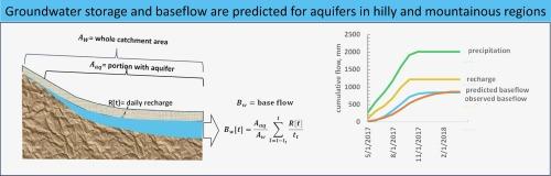
Revisiting the Thornthwaite Mather procedure for baseflow and groundwater storage predictions in sloping and mountainous regions
Hillslope aquifers regulate streamflow and are a critical potable and irrigation water source, especially in developing countries. Knowing recharge and baseflow is essential for managing these aquifers. Methods using available data to calculate recharge and baseflow from aquifers are not valid for uplands. This paper adapts the Thornthwaite and Mather (T-M) procedure from plains to sloping and mountainous regions by replacing the linear reservoir with a zero-order aquifer. The revised T-M procedure was tested over four years in two contrasting watersheds in the humid Ethiopian highlands: the 57 km2 Dangishta with a perennial stream and the nine km2 Robit Bata, where the flow ceased four months after the end of the rain phase. The monthly average groundwater tables were predicted with an accuracy ranging from satisfactory to good for both watersheds. Baseflow predictions were “very good” after considering the evaporation from shallow groundwater in the valley bottom during the dry phase in Dangishta. We conclude that the T-M procedure is ideally suited for calculating recharge, baseflow and groundwater storage in upland regions with sparse hydrological data since the procedure uses as input only rainfall and potential evaporation data that are readily available together with an estimate of the aquifer travel time.

 求助内容:
求助内容: 应助结果提醒方式:


