{"title":"评估海平面上升对土耳其东南部海岸线的影响:沿海脆弱性视角","authors":"Fahri Aykut, Devrim Tezcan","doi":"10.1007/s41064-024-00284-0","DOIUrl":null,"url":null,"abstract":"<p>Coastal areas are inherently sensitive and dynamic, susceptible to natural forces like waves, winds, currents, and tides. Human activities further accelerate coastal changes, while climate change and global sea level rise add to the challenges. Recognizing and safeguarding these coasts, vital for both socioeconomic and environmental reasons, becomes imperative. The objective of this study is to categorize the coasts of the Mersin and İskenderun bays along the southeastern coast of Türkiye based on their vulnerability to natural forces and human-induced factors using the coastal vulnerability index (CVI) method. The study area encompasses approximately 520 km of coastline. The coastal vulnerability analysis reveals that the coastal zone comprises various levels of vulnerability along the total coastline: 24.7% (128 km) is categorized as very high vulnerability, 27.4% (142 km) as high vulnerability, 23.7% (123 km) as moderate vulnerability, and 24.3% (126 km) as low vulnerability. Key parameters influencing vulnerability include coastal slope, land use, and population density. High and very high vulnerability are particularly prominent in coastal plains characterized by gentle slopes, weak geological and geomorphological features, and significant socioeconomic value.</p>","PeriodicalId":56035,"journal":{"name":"PFG-Journal of Photogrammetry Remote Sensing and Geoinformation Science","volume":"51 1","pages":""},"PeriodicalIF":3.3000,"publicationDate":"2024-04-19","publicationTypes":"Journal Article","fieldsOfStudy":null,"isOpenAccess":false,"openAccessPdf":"","citationCount":"0","resultStr":"{\"title\":\"Evaluating Sea Level Rise Impacts on the Southeastern Türkiye Coastline: a Coastal Vulnerability Perspective\",\"authors\":\"Fahri Aykut, Devrim Tezcan\",\"doi\":\"10.1007/s41064-024-00284-0\",\"DOIUrl\":null,\"url\":null,\"abstract\":\"<p>Coastal areas are inherently sensitive and dynamic, susceptible to natural forces like waves, winds, currents, and tides. Human activities further accelerate coastal changes, while climate change and global sea level rise add to the challenges. Recognizing and safeguarding these coasts, vital for both socioeconomic and environmental reasons, becomes imperative. The objective of this study is to categorize the coasts of the Mersin and İskenderun bays along the southeastern coast of Türkiye based on their vulnerability to natural forces and human-induced factors using the coastal vulnerability index (CVI) method. The study area encompasses approximately 520 km of coastline. The coastal vulnerability analysis reveals that the coastal zone comprises various levels of vulnerability along the total coastline: 24.7% (128 km) is categorized as very high vulnerability, 27.4% (142 km) as high vulnerability, 23.7% (123 km) as moderate vulnerability, and 24.3% (126 km) as low vulnerability. Key parameters influencing vulnerability include coastal slope, land use, and population density. High and very high vulnerability are particularly prominent in coastal plains characterized by gentle slopes, weak geological and geomorphological features, and significant socioeconomic value.</p>\",\"PeriodicalId\":56035,\"journal\":{\"name\":\"PFG-Journal of Photogrammetry Remote Sensing and Geoinformation Science\",\"volume\":\"51 1\",\"pages\":\"\"},\"PeriodicalIF\":3.3000,\"publicationDate\":\"2024-04-19\",\"publicationTypes\":\"Journal Article\",\"fieldsOfStudy\":null,\"isOpenAccess\":false,\"openAccessPdf\":\"\",\"citationCount\":\"0\",\"resultStr\":null,\"platform\":\"Semanticscholar\",\"paperid\":null,\"PeriodicalName\":\"PFG-Journal of Photogrammetry Remote Sensing and Geoinformation Science\",\"FirstCategoryId\":\"89\",\"ListUrlMain\":\"https://doi.org/10.1007/s41064-024-00284-0\",\"RegionNum\":4,\"RegionCategory\":\"地球科学\",\"ArticlePicture\":[],\"TitleCN\":null,\"AbstractTextCN\":null,\"PMCID\":null,\"EPubDate\":\"\",\"PubModel\":\"\",\"JCR\":\"Q3\",\"JCRName\":\"IMAGING SCIENCE & PHOTOGRAPHIC TECHNOLOGY\",\"Score\":null,\"Total\":0}","platform":"Semanticscholar","paperid":null,"PeriodicalName":"PFG-Journal of Photogrammetry Remote Sensing and Geoinformation Science","FirstCategoryId":"89","ListUrlMain":"https://doi.org/10.1007/s41064-024-00284-0","RegionNum":4,"RegionCategory":"地球科学","ArticlePicture":[],"TitleCN":null,"AbstractTextCN":null,"PMCID":null,"EPubDate":"","PubModel":"","JCR":"Q3","JCRName":"IMAGING SCIENCE & PHOTOGRAPHIC TECHNOLOGY","Score":null,"Total":0}
Evaluating Sea Level Rise Impacts on the Southeastern Türkiye Coastline: a Coastal Vulnerability Perspective
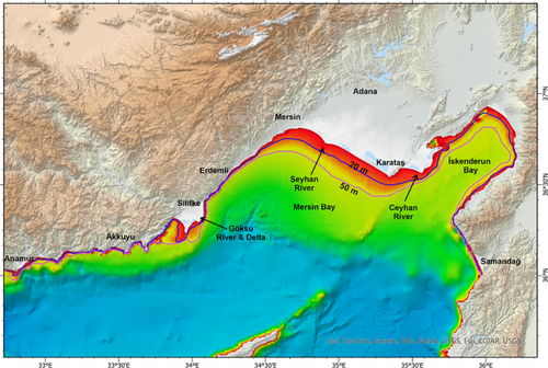
Coastal areas are inherently sensitive and dynamic, susceptible to natural forces like waves, winds, currents, and tides. Human activities further accelerate coastal changes, while climate change and global sea level rise add to the challenges. Recognizing and safeguarding these coasts, vital for both socioeconomic and environmental reasons, becomes imperative. The objective of this study is to categorize the coasts of the Mersin and İskenderun bays along the southeastern coast of Türkiye based on their vulnerability to natural forces and human-induced factors using the coastal vulnerability index (CVI) method. The study area encompasses approximately 520 km of coastline. The coastal vulnerability analysis reveals that the coastal zone comprises various levels of vulnerability along the total coastline: 24.7% (128 km) is categorized as very high vulnerability, 27.4% (142 km) as high vulnerability, 23.7% (123 km) as moderate vulnerability, and 24.3% (126 km) as low vulnerability. Key parameters influencing vulnerability include coastal slope, land use, and population density. High and very high vulnerability are particularly prominent in coastal plains characterized by gentle slopes, weak geological and geomorphological features, and significant socioeconomic value.
期刊介绍:
PFG is an international scholarly journal covering the progress and application of photogrammetric methods, remote sensing technology and the interconnected field of geoinformation science. It places special editorial emphasis on the communication of new methodologies in data acquisition and new approaches to optimized processing and interpretation of all types of data which were acquired by photogrammetric methods, remote sensing, image processing and the computer-aided interpretation of such data in general. The journal hence addresses both researchers and students of these disciplines at academic institutions and universities as well as the downstream users in both the private sector and public administration.
Founded in 1926 under the former name Bildmessung und Luftbildwesen, PFG is worldwide the oldest journal on photogrammetry. It is the official journal of the German Society for Photogrammetry, Remote Sensing and Geoinformation (DGPF).
 求助内容:
求助内容: 应助结果提醒方式:


