Xugang Lian, Lifan Shi, Weiyu Kong, Yu Han, Haodi Fan
{"title":"基于全球导航卫星系统在线监测的地下采矿引起的山区残余沉降时间序列模型","authors":"Xugang Lian, Lifan Shi, Weiyu Kong, Yu Han, Haodi Fan","doi":"10.1007/s40789-024-00685-x","DOIUrl":null,"url":null,"abstract":"<p>The residual subsidence caused by underground mining in mountain area has a long subsidence duration time and great potential harm, which seriously threatens the safety of people's production and life in the mining area. Therefore, it is necessary to use appropriate monitoring methods and mathematical models to effectively monitor and predict the residual subsidence caused by underground mining. Compared with traditional level survey and InSAR (Interferometric Synthetic Aperture Radar) technology, GNSS (Global Navigation Satellite System) online monitoring technology has the advantages of long-term monitoring, high precision and more flexible monitoring methods. The empirical equation method of residual subsidence in mining subsidence is effectively combined with the rock creep equation, which can not only describe the residual subsidence process from the mechanism, but also predict the residual subsidence. Therefore, based on GNSS online monitoring technology, combined with the mining subsidence model of mountain area and adding the correlation coefficient of the compaction degree of caving broken rock and the Kelvin model of rock mechanics, this paper constructs the residual subsidence time series model of arbitrary point on the ground in mountain area. Through the example, the predicted results of the model in the inversion parameter phase and the dynamic prediction phase are compared with the measured data sequence. The results show that the model can carry out effective numerical calculation according to the GNSS monitoring data of any point on the ground, and the model prediction effect is good, which provides a new method for the prediction of residual subsidence in mountain mining.</p>","PeriodicalId":53469,"journal":{"name":"International Journal of Coal Science & Technology","volume":"74 1","pages":""},"PeriodicalIF":8.7000,"publicationDate":"2024-04-06","publicationTypes":"Journal Article","fieldsOfStudy":null,"isOpenAccess":false,"openAccessPdf":"","citationCount":"0","resultStr":"{\"title\":\"Residual subsidence time series model in mountain area caused by underground mining based on GNSS online monitoring\",\"authors\":\"Xugang Lian, Lifan Shi, Weiyu Kong, Yu Han, Haodi Fan\",\"doi\":\"10.1007/s40789-024-00685-x\",\"DOIUrl\":null,\"url\":null,\"abstract\":\"<p>The residual subsidence caused by underground mining in mountain area has a long subsidence duration time and great potential harm, which seriously threatens the safety of people's production and life in the mining area. Therefore, it is necessary to use appropriate monitoring methods and mathematical models to effectively monitor and predict the residual subsidence caused by underground mining. Compared with traditional level survey and InSAR (Interferometric Synthetic Aperture Radar) technology, GNSS (Global Navigation Satellite System) online monitoring technology has the advantages of long-term monitoring, high precision and more flexible monitoring methods. The empirical equation method of residual subsidence in mining subsidence is effectively combined with the rock creep equation, which can not only describe the residual subsidence process from the mechanism, but also predict the residual subsidence. Therefore, based on GNSS online monitoring technology, combined with the mining subsidence model of mountain area and adding the correlation coefficient of the compaction degree of caving broken rock and the Kelvin model of rock mechanics, this paper constructs the residual subsidence time series model of arbitrary point on the ground in mountain area. Through the example, the predicted results of the model in the inversion parameter phase and the dynamic prediction phase are compared with the measured data sequence. The results show that the model can carry out effective numerical calculation according to the GNSS monitoring data of any point on the ground, and the model prediction effect is good, which provides a new method for the prediction of residual subsidence in mountain mining.</p>\",\"PeriodicalId\":53469,\"journal\":{\"name\":\"International Journal of Coal Science & Technology\",\"volume\":\"74 1\",\"pages\":\"\"},\"PeriodicalIF\":8.7000,\"publicationDate\":\"2024-04-06\",\"publicationTypes\":\"Journal Article\",\"fieldsOfStudy\":null,\"isOpenAccess\":false,\"openAccessPdf\":\"\",\"citationCount\":\"0\",\"resultStr\":null,\"platform\":\"Semanticscholar\",\"paperid\":null,\"PeriodicalName\":\"International Journal of Coal Science & Technology\",\"FirstCategoryId\":\"5\",\"ListUrlMain\":\"https://doi.org/10.1007/s40789-024-00685-x\",\"RegionNum\":1,\"RegionCategory\":\"工程技术\",\"ArticlePicture\":[],\"TitleCN\":null,\"AbstractTextCN\":null,\"PMCID\":null,\"EPubDate\":\"\",\"PubModel\":\"\",\"JCR\":\"Q2\",\"JCRName\":\"ENERGY & FUELS\",\"Score\":null,\"Total\":0}","platform":"Semanticscholar","paperid":null,"PeriodicalName":"International Journal of Coal Science & Technology","FirstCategoryId":"5","ListUrlMain":"https://doi.org/10.1007/s40789-024-00685-x","RegionNum":1,"RegionCategory":"工程技术","ArticlePicture":[],"TitleCN":null,"AbstractTextCN":null,"PMCID":null,"EPubDate":"","PubModel":"","JCR":"Q2","JCRName":"ENERGY & FUELS","Score":null,"Total":0}
Residual subsidence time series model in mountain area caused by underground mining based on GNSS online monitoring
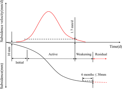
The residual subsidence caused by underground mining in mountain area has a long subsidence duration time and great potential harm, which seriously threatens the safety of people's production and life in the mining area. Therefore, it is necessary to use appropriate monitoring methods and mathematical models to effectively monitor and predict the residual subsidence caused by underground mining. Compared with traditional level survey and InSAR (Interferometric Synthetic Aperture Radar) technology, GNSS (Global Navigation Satellite System) online monitoring technology has the advantages of long-term monitoring, high precision and more flexible monitoring methods. The empirical equation method of residual subsidence in mining subsidence is effectively combined with the rock creep equation, which can not only describe the residual subsidence process from the mechanism, but also predict the residual subsidence. Therefore, based on GNSS online monitoring technology, combined with the mining subsidence model of mountain area and adding the correlation coefficient of the compaction degree of caving broken rock and the Kelvin model of rock mechanics, this paper constructs the residual subsidence time series model of arbitrary point on the ground in mountain area. Through the example, the predicted results of the model in the inversion parameter phase and the dynamic prediction phase are compared with the measured data sequence. The results show that the model can carry out effective numerical calculation according to the GNSS monitoring data of any point on the ground, and the model prediction effect is good, which provides a new method for the prediction of residual subsidence in mountain mining.
期刊介绍:
The International Journal of Coal Science & Technology is a peer-reviewed open access journal that focuses on key topics of coal scientific research and mining development. It serves as a forum for scientists to present research findings and discuss challenging issues in the field.
The journal covers a range of topics including coal geology, geochemistry, geophysics, mineralogy, and petrology. It also covers coal mining theory, technology, and engineering, as well as coal processing, utilization, and conversion. Additionally, the journal explores coal mining environment and reclamation, along with related aspects.
The International Journal of Coal Science & Technology is published with China Coal Society, who also cover the publication costs. This means that authors do not need to pay an article-processing charge.

 求助内容:
求助内容: 应助结果提醒方式:


