{"title":"利用迁移学习从天空卫星图像中探测建筑物:安卡拉上空的案例研究","authors":"Kanako Sawa, Ilyas Yalcin, Sultan Kocaman","doi":"10.1007/s41064-024-00279-x","DOIUrl":null,"url":null,"abstract":"<p>The detection and continuous updating of buildings in geodatabases has long been a major research area in geographic information science and is an important theme for national mapping agencies. Advancements in machine learning techniques, particularly state-of-the-art deep learning (DL) models, offer promising solutions for extracting and modeling building rooftops from images. However, tasks such as automatic labelling of learning data and the generalizability of models remain challenging. In this study, we assessed the sensor and geographic area adaptation capabilities of a pretrained DL model implemented in the ArcGIS environment using very-high-resolution (50 cm) SkySat imagery. The model was trained for digitizing building footprints via Mask R‑CNN with a ResNet50 backbone using aerial and satellite images from parts of the USA. Here, we utilized images from three different SkySat satellites with various acquisition dates and off-nadir angles and refined the pretrained model using small numbers of buildings as training data (5–53 buildings) over Ankara. We evaluated the buildings in areas with different characteristics, such as urban transformation, slums, regular, and obtained high accuracies with F‑1 scores of 0.92, 0.94, and 0.96 from SkySat 4, 7, and 17, respectively. The study findings showed that the DL model has high transfer learning capability for Ankara using only a few buildings and that the recent SkySat satellites demonstrate superior image quality.</p>","PeriodicalId":56035,"journal":{"name":"PFG-Journal of Photogrammetry Remote Sensing and Geoinformation Science","volume":"40 1","pages":""},"PeriodicalIF":2.1000,"publicationDate":"2024-03-18","publicationTypes":"Journal Article","fieldsOfStudy":null,"isOpenAccess":false,"openAccessPdf":"","citationCount":"0","resultStr":"{\"title\":\"Building Detection from SkySat Images with Transfer Learning: a Case Study over Ankara\",\"authors\":\"Kanako Sawa, Ilyas Yalcin, Sultan Kocaman\",\"doi\":\"10.1007/s41064-024-00279-x\",\"DOIUrl\":null,\"url\":null,\"abstract\":\"<p>The detection and continuous updating of buildings in geodatabases has long been a major research area in geographic information science and is an important theme for national mapping agencies. Advancements in machine learning techniques, particularly state-of-the-art deep learning (DL) models, offer promising solutions for extracting and modeling building rooftops from images. However, tasks such as automatic labelling of learning data and the generalizability of models remain challenging. In this study, we assessed the sensor and geographic area adaptation capabilities of a pretrained DL model implemented in the ArcGIS environment using very-high-resolution (50 cm) SkySat imagery. The model was trained for digitizing building footprints via Mask R‑CNN with a ResNet50 backbone using aerial and satellite images from parts of the USA. Here, we utilized images from three different SkySat satellites with various acquisition dates and off-nadir angles and refined the pretrained model using small numbers of buildings as training data (5–53 buildings) over Ankara. We evaluated the buildings in areas with different characteristics, such as urban transformation, slums, regular, and obtained high accuracies with F‑1 scores of 0.92, 0.94, and 0.96 from SkySat 4, 7, and 17, respectively. The study findings showed that the DL model has high transfer learning capability for Ankara using only a few buildings and that the recent SkySat satellites demonstrate superior image quality.</p>\",\"PeriodicalId\":56035,\"journal\":{\"name\":\"PFG-Journal of Photogrammetry Remote Sensing and Geoinformation Science\",\"volume\":\"40 1\",\"pages\":\"\"},\"PeriodicalIF\":2.1000,\"publicationDate\":\"2024-03-18\",\"publicationTypes\":\"Journal Article\",\"fieldsOfStudy\":null,\"isOpenAccess\":false,\"openAccessPdf\":\"\",\"citationCount\":\"0\",\"resultStr\":null,\"platform\":\"Semanticscholar\",\"paperid\":null,\"PeriodicalName\":\"PFG-Journal of Photogrammetry Remote Sensing and Geoinformation Science\",\"FirstCategoryId\":\"89\",\"ListUrlMain\":\"https://doi.org/10.1007/s41064-024-00279-x\",\"RegionNum\":4,\"RegionCategory\":\"地球科学\",\"ArticlePicture\":[],\"TitleCN\":null,\"AbstractTextCN\":null,\"PMCID\":null,\"EPubDate\":\"\",\"PubModel\":\"\",\"JCR\":\"Q3\",\"JCRName\":\"IMAGING SCIENCE & PHOTOGRAPHIC TECHNOLOGY\",\"Score\":null,\"Total\":0}","platform":"Semanticscholar","paperid":null,"PeriodicalName":"PFG-Journal of Photogrammetry Remote Sensing and Geoinformation Science","FirstCategoryId":"89","ListUrlMain":"https://doi.org/10.1007/s41064-024-00279-x","RegionNum":4,"RegionCategory":"地球科学","ArticlePicture":[],"TitleCN":null,"AbstractTextCN":null,"PMCID":null,"EPubDate":"","PubModel":"","JCR":"Q3","JCRName":"IMAGING SCIENCE & PHOTOGRAPHIC TECHNOLOGY","Score":null,"Total":0}
Building Detection from SkySat Images with Transfer Learning: a Case Study over Ankara
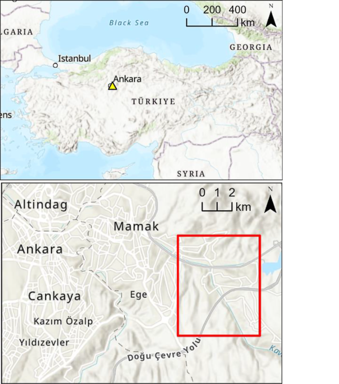
The detection and continuous updating of buildings in geodatabases has long been a major research area in geographic information science and is an important theme for national mapping agencies. Advancements in machine learning techniques, particularly state-of-the-art deep learning (DL) models, offer promising solutions for extracting and modeling building rooftops from images. However, tasks such as automatic labelling of learning data and the generalizability of models remain challenging. In this study, we assessed the sensor and geographic area adaptation capabilities of a pretrained DL model implemented in the ArcGIS environment using very-high-resolution (50 cm) SkySat imagery. The model was trained for digitizing building footprints via Mask R‑CNN with a ResNet50 backbone using aerial and satellite images from parts of the USA. Here, we utilized images from three different SkySat satellites with various acquisition dates and off-nadir angles and refined the pretrained model using small numbers of buildings as training data (5–53 buildings) over Ankara. We evaluated the buildings in areas with different characteristics, such as urban transformation, slums, regular, and obtained high accuracies with F‑1 scores of 0.92, 0.94, and 0.96 from SkySat 4, 7, and 17, respectively. The study findings showed that the DL model has high transfer learning capability for Ankara using only a few buildings and that the recent SkySat satellites demonstrate superior image quality.
期刊介绍:
PFG is an international scholarly journal covering the progress and application of photogrammetric methods, remote sensing technology and the interconnected field of geoinformation science. It places special editorial emphasis on the communication of new methodologies in data acquisition and new approaches to optimized processing and interpretation of all types of data which were acquired by photogrammetric methods, remote sensing, image processing and the computer-aided interpretation of such data in general. The journal hence addresses both researchers and students of these disciplines at academic institutions and universities as well as the downstream users in both the private sector and public administration.
Founded in 1926 under the former name Bildmessung und Luftbildwesen, PFG is worldwide the oldest journal on photogrammetry. It is the official journal of the German Society for Photogrammetry, Remote Sensing and Geoinformation (DGPF).
 求助内容:
求助内容: 应助结果提醒方式:


