Yucheng Su, Shuai Fu, Boyang Jiao, Yekang Su, Taoning Mao, Yuping He, Yi Jiang
{"title":"深度学习在 GNSS 数据集海面高度估算中的应用","authors":"Yucheng Su, Shuai Fu, Boyang Jiao, Yekang Su, Taoning Mao, Yuping He, Yi Jiang","doi":"10.1134/s1028334x2360322x","DOIUrl":null,"url":null,"abstract":"<h3 data-test=\"abstract-sub-heading\">Abstract</h3><p>In this work, we used the convolutional neural network (CNN) method to invert sea surface height (SSH) from the Global Navigation Satellite System (GNSS) delayed Doppler map (DDM) data during 2009–2017 and compared the CNN inversion data with those obtained from traditional simple random forest (RF) method. SSH observations from the OSTM/Jason-2 satellite were used to judge the merits of the two methods. The results show that both methods yield good SSH inversion results, but when the training set is 9000, the root mean square errors of the SSH inversion results based on the CNN and the RF method are 16.78 and 15.96 respectively; as the training set increases above 9000, the accuracy of the CNN method is significantly better than that of the RF method. This suggests that SSH inversion based on the CNN method will become more advantageous as more data become available.</p>","PeriodicalId":11352,"journal":{"name":"Doklady Earth Sciences","volume":null,"pages":null},"PeriodicalIF":0.7000,"publicationDate":"2024-03-18","publicationTypes":"Journal Article","fieldsOfStudy":null,"isOpenAccess":false,"openAccessPdf":"","citationCount":"0","resultStr":"{\"title\":\"Application of Deep Learning in Sea Surface Height Estimation of GNSS Data Sets\",\"authors\":\"Yucheng Su, Shuai Fu, Boyang Jiao, Yekang Su, Taoning Mao, Yuping He, Yi Jiang\",\"doi\":\"10.1134/s1028334x2360322x\",\"DOIUrl\":null,\"url\":null,\"abstract\":\"<h3 data-test=\\\"abstract-sub-heading\\\">Abstract</h3><p>In this work, we used the convolutional neural network (CNN) method to invert sea surface height (SSH) from the Global Navigation Satellite System (GNSS) delayed Doppler map (DDM) data during 2009–2017 and compared the CNN inversion data with those obtained from traditional simple random forest (RF) method. SSH observations from the OSTM/Jason-2 satellite were used to judge the merits of the two methods. The results show that both methods yield good SSH inversion results, but when the training set is 9000, the root mean square errors of the SSH inversion results based on the CNN and the RF method are 16.78 and 15.96 respectively; as the training set increases above 9000, the accuracy of the CNN method is significantly better than that of the RF method. This suggests that SSH inversion based on the CNN method will become more advantageous as more data become available.</p>\",\"PeriodicalId\":11352,\"journal\":{\"name\":\"Doklady Earth Sciences\",\"volume\":null,\"pages\":null},\"PeriodicalIF\":0.7000,\"publicationDate\":\"2024-03-18\",\"publicationTypes\":\"Journal Article\",\"fieldsOfStudy\":null,\"isOpenAccess\":false,\"openAccessPdf\":\"\",\"citationCount\":\"0\",\"resultStr\":null,\"platform\":\"Semanticscholar\",\"paperid\":null,\"PeriodicalName\":\"Doklady Earth Sciences\",\"FirstCategoryId\":\"89\",\"ListUrlMain\":\"https://doi.org/10.1134/s1028334x2360322x\",\"RegionNum\":4,\"RegionCategory\":\"地球科学\",\"ArticlePicture\":[],\"TitleCN\":null,\"AbstractTextCN\":null,\"PMCID\":null,\"EPubDate\":\"\",\"PubModel\":\"\",\"JCR\":\"Q4\",\"JCRName\":\"GEOSCIENCES, MULTIDISCIPLINARY\",\"Score\":null,\"Total\":0}","platform":"Semanticscholar","paperid":null,"PeriodicalName":"Doklady Earth Sciences","FirstCategoryId":"89","ListUrlMain":"https://doi.org/10.1134/s1028334x2360322x","RegionNum":4,"RegionCategory":"地球科学","ArticlePicture":[],"TitleCN":null,"AbstractTextCN":null,"PMCID":null,"EPubDate":"","PubModel":"","JCR":"Q4","JCRName":"GEOSCIENCES, MULTIDISCIPLINARY","Score":null,"Total":0}
Application of Deep Learning in Sea Surface Height Estimation of GNSS Data Sets
Abstract
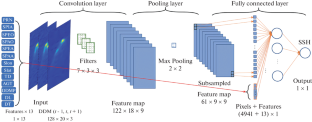
In this work, we used the convolutional neural network (CNN) method to invert sea surface height (SSH) from the Global Navigation Satellite System (GNSS) delayed Doppler map (DDM) data during 2009–2017 and compared the CNN inversion data with those obtained from traditional simple random forest (RF) method. SSH observations from the OSTM/Jason-2 satellite were used to judge the merits of the two methods. The results show that both methods yield good SSH inversion results, but when the training set is 9000, the root mean square errors of the SSH inversion results based on the CNN and the RF method are 16.78 and 15.96 respectively; as the training set increases above 9000, the accuracy of the CNN method is significantly better than that of the RF method. This suggests that SSH inversion based on the CNN method will become more advantageous as more data become available.
期刊介绍:
Doklady Earth Sciences is a journal that publishes new research in Earth science of great significance. Initially the journal was a forum of the Russian Academy of Science and published only best contributions from Russia. Now the journal welcomes submissions from any country in the English or Russian language. Every manuscript must be recommended by Russian or foreign members of the Russian Academy of Sciences.
 求助内容:
求助内容: 应助结果提醒方式:


