{"title":"利用嵌套 UNet 模型和 NASA 基准数据集从哨兵-1 数据中自动检测洪水","authors":"Binayak Ghosh, Shagun Garg, Mahdi Motagh, Sandro Martinis","doi":"10.1007/s41064-024-00275-1","DOIUrl":null,"url":null,"abstract":"<p>During flood events near real-time, synthetic aperture radar (SAR) satellite imagery has proven to be an efficient management tool for disaster management authorities. However, one of the challenges is accurate classification and segmentation of flooded water. A common method of SAR-based flood mapping is binary segmentation by thresholding, but this method is limited due to the effects of backscatter, geographical area, and surface characterstics. Recent advancements in deep learning algorithms for image segmentation have demonstrated excellent potential for improving flood detection. In this paper, we present a deep learning approach with a nested UNet architecture based on a backbone of EfficientNet-B7 by leveraging a publicly available Sentinel‑1 dataset provided jointly by NASA and the IEEE GRSS Committee. The performance of the nested UNet model was compared with several other UNet-based convolutional neural network architectures. The models were trained on flood events from Nebraska and North Alabama in the USA, Bangladesh, and Florence, Italy. Finally, the generalization capacity of the trained nested UNet model was compared to the other architectures by testing on Sentinel‑1 data from flood events of varied geographical regions such as Spain, India, and Vietnam. The impact of using different polarization band combinations of input data on the segmentation capabilities of the nested UNet and other models is also evaluated using Shapley scores. The results of these experiments show that the UNet model architectures perform comparably to the UNet++ with EfficientNet-B7 backbone for both the NASA dataset as well as the other test cases. Therefore, it can be inferred that these models can be trained on certain flood events provided in the dataset and used for flood detection in other geographical areas, thus proving the transferability of these models. However, the effect of polarization still varies across different test cases from around the world in terms of performance; the model trained with the combinations of individual bands, VV and VH, and polarization ratios gives the best results.</p>","PeriodicalId":56035,"journal":{"name":"PFG-Journal of Photogrammetry Remote Sensing and Geoinformation Science","volume":"13 1","pages":""},"PeriodicalIF":2.1000,"publicationDate":"2024-03-12","publicationTypes":"Journal Article","fieldsOfStudy":null,"isOpenAccess":false,"openAccessPdf":"","citationCount":"0","resultStr":"{\"title\":\"Automatic Flood Detection from Sentinel-1 Data Using a Nested UNet Model and a NASA Benchmark Dataset\",\"authors\":\"Binayak Ghosh, Shagun Garg, Mahdi Motagh, Sandro Martinis\",\"doi\":\"10.1007/s41064-024-00275-1\",\"DOIUrl\":null,\"url\":null,\"abstract\":\"<p>During flood events near real-time, synthetic aperture radar (SAR) satellite imagery has proven to be an efficient management tool for disaster management authorities. However, one of the challenges is accurate classification and segmentation of flooded water. A common method of SAR-based flood mapping is binary segmentation by thresholding, but this method is limited due to the effects of backscatter, geographical area, and surface characterstics. Recent advancements in deep learning algorithms for image segmentation have demonstrated excellent potential for improving flood detection. In this paper, we present a deep learning approach with a nested UNet architecture based on a backbone of EfficientNet-B7 by leveraging a publicly available Sentinel‑1 dataset provided jointly by NASA and the IEEE GRSS Committee. The performance of the nested UNet model was compared with several other UNet-based convolutional neural network architectures. The models were trained on flood events from Nebraska and North Alabama in the USA, Bangladesh, and Florence, Italy. Finally, the generalization capacity of the trained nested UNet model was compared to the other architectures by testing on Sentinel‑1 data from flood events of varied geographical regions such as Spain, India, and Vietnam. The impact of using different polarization band combinations of input data on the segmentation capabilities of the nested UNet and other models is also evaluated using Shapley scores. The results of these experiments show that the UNet model architectures perform comparably to the UNet++ with EfficientNet-B7 backbone for both the NASA dataset as well as the other test cases. Therefore, it can be inferred that these models can be trained on certain flood events provided in the dataset and used for flood detection in other geographical areas, thus proving the transferability of these models. However, the effect of polarization still varies across different test cases from around the world in terms of performance; the model trained with the combinations of individual bands, VV and VH, and polarization ratios gives the best results.</p>\",\"PeriodicalId\":56035,\"journal\":{\"name\":\"PFG-Journal of Photogrammetry Remote Sensing and Geoinformation Science\",\"volume\":\"13 1\",\"pages\":\"\"},\"PeriodicalIF\":2.1000,\"publicationDate\":\"2024-03-12\",\"publicationTypes\":\"Journal Article\",\"fieldsOfStudy\":null,\"isOpenAccess\":false,\"openAccessPdf\":\"\",\"citationCount\":\"0\",\"resultStr\":null,\"platform\":\"Semanticscholar\",\"paperid\":null,\"PeriodicalName\":\"PFG-Journal of Photogrammetry Remote Sensing and Geoinformation Science\",\"FirstCategoryId\":\"89\",\"ListUrlMain\":\"https://doi.org/10.1007/s41064-024-00275-1\",\"RegionNum\":4,\"RegionCategory\":\"地球科学\",\"ArticlePicture\":[],\"TitleCN\":null,\"AbstractTextCN\":null,\"PMCID\":null,\"EPubDate\":\"\",\"PubModel\":\"\",\"JCR\":\"Q3\",\"JCRName\":\"IMAGING SCIENCE & PHOTOGRAPHIC TECHNOLOGY\",\"Score\":null,\"Total\":0}","platform":"Semanticscholar","paperid":null,"PeriodicalName":"PFG-Journal of Photogrammetry Remote Sensing and Geoinformation Science","FirstCategoryId":"89","ListUrlMain":"https://doi.org/10.1007/s41064-024-00275-1","RegionNum":4,"RegionCategory":"地球科学","ArticlePicture":[],"TitleCN":null,"AbstractTextCN":null,"PMCID":null,"EPubDate":"","PubModel":"","JCR":"Q3","JCRName":"IMAGING SCIENCE & PHOTOGRAPHIC TECHNOLOGY","Score":null,"Total":0}
Automatic Flood Detection from Sentinel-1 Data Using a Nested UNet Model and a NASA Benchmark Dataset
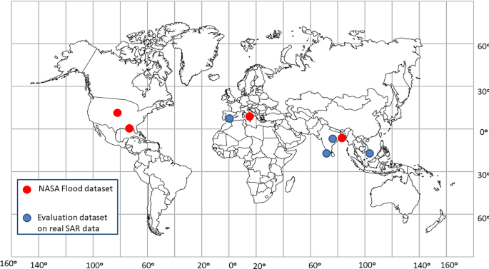
During flood events near real-time, synthetic aperture radar (SAR) satellite imagery has proven to be an efficient management tool for disaster management authorities. However, one of the challenges is accurate classification and segmentation of flooded water. A common method of SAR-based flood mapping is binary segmentation by thresholding, but this method is limited due to the effects of backscatter, geographical area, and surface characterstics. Recent advancements in deep learning algorithms for image segmentation have demonstrated excellent potential for improving flood detection. In this paper, we present a deep learning approach with a nested UNet architecture based on a backbone of EfficientNet-B7 by leveraging a publicly available Sentinel‑1 dataset provided jointly by NASA and the IEEE GRSS Committee. The performance of the nested UNet model was compared with several other UNet-based convolutional neural network architectures. The models were trained on flood events from Nebraska and North Alabama in the USA, Bangladesh, and Florence, Italy. Finally, the generalization capacity of the trained nested UNet model was compared to the other architectures by testing on Sentinel‑1 data from flood events of varied geographical regions such as Spain, India, and Vietnam. The impact of using different polarization band combinations of input data on the segmentation capabilities of the nested UNet and other models is also evaluated using Shapley scores. The results of these experiments show that the UNet model architectures perform comparably to the UNet++ with EfficientNet-B7 backbone for both the NASA dataset as well as the other test cases. Therefore, it can be inferred that these models can be trained on certain flood events provided in the dataset and used for flood detection in other geographical areas, thus proving the transferability of these models. However, the effect of polarization still varies across different test cases from around the world in terms of performance; the model trained with the combinations of individual bands, VV and VH, and polarization ratios gives the best results.
期刊介绍:
PFG is an international scholarly journal covering the progress and application of photogrammetric methods, remote sensing technology and the interconnected field of geoinformation science. It places special editorial emphasis on the communication of new methodologies in data acquisition and new approaches to optimized processing and interpretation of all types of data which were acquired by photogrammetric methods, remote sensing, image processing and the computer-aided interpretation of such data in general. The journal hence addresses both researchers and students of these disciplines at academic institutions and universities as well as the downstream users in both the private sector and public administration.
Founded in 1926 under the former name Bildmessung und Luftbildwesen, PFG is worldwide the oldest journal on photogrammetry. It is the official journal of the German Society for Photogrammetry, Remote Sensing and Geoinformation (DGPF).
 求助内容:
求助内容: 应助结果提醒方式:


