Xiang Liu, Julian Frey, Catalina Munteanu, Martin Denter, Barbara Koch
{"title":"从空间光学图像绘制树种多样性图:光谱和空间分辨率的影响","authors":"Xiang Liu, Julian Frey, Catalina Munteanu, Martin Denter, Barbara Koch","doi":"10.1002/rse2.383","DOIUrl":null,"url":null,"abstract":"Increasingly available spaceborne sensors provide unprecedented opportunities for large-scale, timely and continuous tree species diversity (TSD) monitoring. However, given differences in spectral and spatial resolutions, the choice of sensor is not always straightforward. In this work, we investigated the effects of spatial and spectral resolutions for four spaceborne sensors (RapidEye, Landsat-8, Sentinel-2 and PlanetScope) on TSD mapping in an area of approximately 4000 km<sup>2</sup> within the Black Forest, Germany. We employed a random forest (RF) regression model to predict Shannon–Wiener diversity based on seven types of spectral heterogeneity metrics (texture, coefficient of variation, Rao's Q, convex hull volume, spectral angle mapper, convex hull area and spectral species diversity) and a full survey dataset from 135 one-ha sample plots. We compared the RF model's performance across sensors and spatial resolutions. Our results demonstrated that the Sentinel-2-based TSD model achieved the highest accuracy (mean <i>R</i><sup>2</sup>: 0.477, mean root-mean-square error (RMSE): 0.274). The RapidEye-based TSD model produced lower accuracy (mean <i>R</i><sup>2</sup>: 0.346, mean RMSE: 0.303), but it was better than the PlanetScope- and Landsat-based TSD models. The 10 m (for Sentinel-2 and RapidEye) and 15 m (for PlanetScope) were the best spatial resolutions for predicting TSD. The NIR band was the most favourable spectral band for predicting TSD. Texture metrics and Rao's Q outperformed the other spectral heterogeneity metrics. Our results highlighted that spaceborne optical imagery (especially Sentinel-2) can be successfully used for large-scale TSD mapping but that the choice of sensors can significantly affect the resulting mapping accuracy in temperate montane forests.","PeriodicalId":21132,"journal":{"name":"Remote Sensing in Ecology and Conservation","volume":"29 1","pages":""},"PeriodicalIF":3.9000,"publicationDate":"2024-02-19","publicationTypes":"Journal Article","fieldsOfStudy":null,"isOpenAccess":false,"openAccessPdf":"","citationCount":"0","resultStr":"{\"title\":\"Tree species diversity mapping from spaceborne optical images: The effects of spectral and spatial resolution\",\"authors\":\"Xiang Liu, Julian Frey, Catalina Munteanu, Martin Denter, Barbara Koch\",\"doi\":\"10.1002/rse2.383\",\"DOIUrl\":null,\"url\":null,\"abstract\":\"Increasingly available spaceborne sensors provide unprecedented opportunities for large-scale, timely and continuous tree species diversity (TSD) monitoring. However, given differences in spectral and spatial resolutions, the choice of sensor is not always straightforward. In this work, we investigated the effects of spatial and spectral resolutions for four spaceborne sensors (RapidEye, Landsat-8, Sentinel-2 and PlanetScope) on TSD mapping in an area of approximately 4000 km<sup>2</sup> within the Black Forest, Germany. We employed a random forest (RF) regression model to predict Shannon–Wiener diversity based on seven types of spectral heterogeneity metrics (texture, coefficient of variation, Rao's Q, convex hull volume, spectral angle mapper, convex hull area and spectral species diversity) and a full survey dataset from 135 one-ha sample plots. We compared the RF model's performance across sensors and spatial resolutions. Our results demonstrated that the Sentinel-2-based TSD model achieved the highest accuracy (mean <i>R</i><sup>2</sup>: 0.477, mean root-mean-square error (RMSE): 0.274). The RapidEye-based TSD model produced lower accuracy (mean <i>R</i><sup>2</sup>: 0.346, mean RMSE: 0.303), but it was better than the PlanetScope- and Landsat-based TSD models. The 10 m (for Sentinel-2 and RapidEye) and 15 m (for PlanetScope) were the best spatial resolutions for predicting TSD. The NIR band was the most favourable spectral band for predicting TSD. Texture metrics and Rao's Q outperformed the other spectral heterogeneity metrics. Our results highlighted that spaceborne optical imagery (especially Sentinel-2) can be successfully used for large-scale TSD mapping but that the choice of sensors can significantly affect the resulting mapping accuracy in temperate montane forests.\",\"PeriodicalId\":21132,\"journal\":{\"name\":\"Remote Sensing in Ecology and Conservation\",\"volume\":\"29 1\",\"pages\":\"\"},\"PeriodicalIF\":3.9000,\"publicationDate\":\"2024-02-19\",\"publicationTypes\":\"Journal Article\",\"fieldsOfStudy\":null,\"isOpenAccess\":false,\"openAccessPdf\":\"\",\"citationCount\":\"0\",\"resultStr\":null,\"platform\":\"Semanticscholar\",\"paperid\":null,\"PeriodicalName\":\"Remote Sensing in Ecology and Conservation\",\"FirstCategoryId\":\"93\",\"ListUrlMain\":\"https://doi.org/10.1002/rse2.383\",\"RegionNum\":2,\"RegionCategory\":\"环境科学与生态学\",\"ArticlePicture\":[],\"TitleCN\":null,\"AbstractTextCN\":null,\"PMCID\":null,\"EPubDate\":\"\",\"PubModel\":\"\",\"JCR\":\"Q1\",\"JCRName\":\"ECOLOGY\",\"Score\":null,\"Total\":0}","platform":"Semanticscholar","paperid":null,"PeriodicalName":"Remote Sensing in Ecology and Conservation","FirstCategoryId":"93","ListUrlMain":"https://doi.org/10.1002/rse2.383","RegionNum":2,"RegionCategory":"环境科学与生态学","ArticlePicture":[],"TitleCN":null,"AbstractTextCN":null,"PMCID":null,"EPubDate":"","PubModel":"","JCR":"Q1","JCRName":"ECOLOGY","Score":null,"Total":0}
Tree species diversity mapping from spaceborne optical images: The effects of spectral and spatial resolution
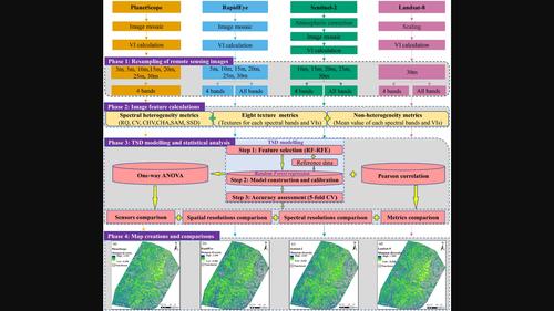
Increasingly available spaceborne sensors provide unprecedented opportunities for large-scale, timely and continuous tree species diversity (TSD) monitoring. However, given differences in spectral and spatial resolutions, the choice of sensor is not always straightforward. In this work, we investigated the effects of spatial and spectral resolutions for four spaceborne sensors (RapidEye, Landsat-8, Sentinel-2 and PlanetScope) on TSD mapping in an area of approximately 4000 km2 within the Black Forest, Germany. We employed a random forest (RF) regression model to predict Shannon–Wiener diversity based on seven types of spectral heterogeneity metrics (texture, coefficient of variation, Rao's Q, convex hull volume, spectral angle mapper, convex hull area and spectral species diversity) and a full survey dataset from 135 one-ha sample plots. We compared the RF model's performance across sensors and spatial resolutions. Our results demonstrated that the Sentinel-2-based TSD model achieved the highest accuracy (mean R2: 0.477, mean root-mean-square error (RMSE): 0.274). The RapidEye-based TSD model produced lower accuracy (mean R2: 0.346, mean RMSE: 0.303), but it was better than the PlanetScope- and Landsat-based TSD models. The 10 m (for Sentinel-2 and RapidEye) and 15 m (for PlanetScope) were the best spatial resolutions for predicting TSD. The NIR band was the most favourable spectral band for predicting TSD. Texture metrics and Rao's Q outperformed the other spectral heterogeneity metrics. Our results highlighted that spaceborne optical imagery (especially Sentinel-2) can be successfully used for large-scale TSD mapping but that the choice of sensors can significantly affect the resulting mapping accuracy in temperate montane forests.
期刊介绍:
emote Sensing in Ecology and Conservation provides a forum for rapid, peer-reviewed publication of novel, multidisciplinary research at the interface between remote sensing science and ecology and conservation. The journal prioritizes findings that advance the scientific basis of ecology and conservation, promoting the development of remote-sensing based methods relevant to the management of land use and biological systems at all levels, from populations and species to ecosystems and biomes. The journal defines remote sensing in its broadest sense, including data acquisition by hand-held and fixed ground-based sensors, such as camera traps and acoustic recorders, and sensors on airplanes and satellites. The intended journal’s audience includes ecologists, conservation scientists, policy makers, managers of terrestrial and aquatic systems, remote sensing scientists, and students.
Remote Sensing in Ecology and Conservation is a fully open access journal from Wiley and the Zoological Society of London. Remote sensing has enormous potential as to provide information on the state of, and pressures on, biological diversity and ecosystem services, at multiple spatial and temporal scales. This new publication provides a forum for multidisciplinary research in remote sensing science, ecological research and conservation science.