Miguel Vallejo Orti , Katharina Anders , Oluibukun Ajayi , Olaf Bubenzer , Bernhard Höfle
{"title":"利用卡尔曼滤波和机器学习相结合的方法,整合多用户数字化行动,绘制沟壑轮廓图","authors":"Miguel Vallejo Orti , Katharina Anders , Oluibukun Ajayi , Olaf Bubenzer , Bernhard Höfle","doi":"10.1016/j.ophoto.2024.100059","DOIUrl":null,"url":null,"abstract":"<div><p>Scalable and transferable methods for generating reliable reference data for automated remote sensing approaches are crucial, especially for mapping complex Earth surface processes such as gully erosion in low-populated and inaccessible areas. As an alternative for the labour-intense in-situ authoritative mapping, collaborative approaches enable volunteers to generate redundant independent geoinformation by digitising Earth observation imagery. We face the challenge of mapping the complex gully outlines integrating multi-user contributions of the same gully network. Comparing Sentinel 2, Bing Aerial, and unoccupied aerial vehicle orthophoto base maps, we examine the volunteered geographic information process and multi-contribution integration using Kalman filtering and machine learning to segment a gully border in a remote area in northwestern Namibia. The Kalman filtering integrates the different lines finding a smoothed solution, and a Random Forest model is used to identify mapping conditions and terrain features as key predictors for evaluating contributors' digitising quality. Assessing results with expert-based reference data, we identify ten contributions as optimal, yielding root mean square distance values of 19.1 m, 15.9 m and 16.6 m, and variability of 2.0 m, 4.2 m and 3.8 m (root mean square distance standard deviation) for Sentinel 2, Bing Aerial, and unoccupied aerial vehicle orthophoto, respectively. Eliminating the lowest performing contributions for Sentinel 2 using a Random Forest regression-based quality indicator improves the accuracy by up to 35% in the root mean square distance compared to a random selection, and up to 54% compared to a supervised remote sensing classification. Results for Sentinel 2 show that low slope, low terrain ruggedness index, and high normalised difference vegetation index values are correlated to high spatial mapping deviations, with Pearson correlation coefficients of −0.61, −0.5, and 0.18, respectively. Our approach is a powerful alternative for authoritative mapping of morphologically complex environmental phenomena and can provide independent reference data for supervised automatic remote sensing analysis.</p></div>","PeriodicalId":100730,"journal":{"name":"ISPRS Open Journal of Photogrammetry and Remote Sensing","volume":"12 ","pages":"Article 100059"},"PeriodicalIF":0.0000,"publicationDate":"2024-02-10","publicationTypes":"Journal Article","fieldsOfStudy":null,"isOpenAccess":false,"openAccessPdf":"https://www.sciencedirect.com/science/article/pii/S2667393224000024/pdfft?md5=48a1afef19ee80fc26305409481984b5&pid=1-s2.0-S2667393224000024-main.pdf","citationCount":"0","resultStr":"{\"title\":\"Integrating multi-user digitising actions for mapping gully outlines using a combined approach of Kalman filtering and machine learning\",\"authors\":\"Miguel Vallejo Orti , Katharina Anders , Oluibukun Ajayi , Olaf Bubenzer , Bernhard Höfle\",\"doi\":\"10.1016/j.ophoto.2024.100059\",\"DOIUrl\":null,\"url\":null,\"abstract\":\"<div><p>Scalable and transferable methods for generating reliable reference data for automated remote sensing approaches are crucial, especially for mapping complex Earth surface processes such as gully erosion in low-populated and inaccessible areas. As an alternative for the labour-intense in-situ authoritative mapping, collaborative approaches enable volunteers to generate redundant independent geoinformation by digitising Earth observation imagery. We face the challenge of mapping the complex gully outlines integrating multi-user contributions of the same gully network. Comparing Sentinel 2, Bing Aerial, and unoccupied aerial vehicle orthophoto base maps, we examine the volunteered geographic information process and multi-contribution integration using Kalman filtering and machine learning to segment a gully border in a remote area in northwestern Namibia. The Kalman filtering integrates the different lines finding a smoothed solution, and a Random Forest model is used to identify mapping conditions and terrain features as key predictors for evaluating contributors' digitising quality. Assessing results with expert-based reference data, we identify ten contributions as optimal, yielding root mean square distance values of 19.1 m, 15.9 m and 16.6 m, and variability of 2.0 m, 4.2 m and 3.8 m (root mean square distance standard deviation) for Sentinel 2, Bing Aerial, and unoccupied aerial vehicle orthophoto, respectively. Eliminating the lowest performing contributions for Sentinel 2 using a Random Forest regression-based quality indicator improves the accuracy by up to 35% in the root mean square distance compared to a random selection, and up to 54% compared to a supervised remote sensing classification. Results for Sentinel 2 show that low slope, low terrain ruggedness index, and high normalised difference vegetation index values are correlated to high spatial mapping deviations, with Pearson correlation coefficients of −0.61, −0.5, and 0.18, respectively. Our approach is a powerful alternative for authoritative mapping of morphologically complex environmental phenomena and can provide independent reference data for supervised automatic remote sensing analysis.</p></div>\",\"PeriodicalId\":100730,\"journal\":{\"name\":\"ISPRS Open Journal of Photogrammetry and Remote Sensing\",\"volume\":\"12 \",\"pages\":\"Article 100059\"},\"PeriodicalIF\":0.0000,\"publicationDate\":\"2024-02-10\",\"publicationTypes\":\"Journal Article\",\"fieldsOfStudy\":null,\"isOpenAccess\":false,\"openAccessPdf\":\"https://www.sciencedirect.com/science/article/pii/S2667393224000024/pdfft?md5=48a1afef19ee80fc26305409481984b5&pid=1-s2.0-S2667393224000024-main.pdf\",\"citationCount\":\"0\",\"resultStr\":null,\"platform\":\"Semanticscholar\",\"paperid\":null,\"PeriodicalName\":\"ISPRS Open Journal of Photogrammetry and Remote Sensing\",\"FirstCategoryId\":\"1085\",\"ListUrlMain\":\"https://www.sciencedirect.com/science/article/pii/S2667393224000024\",\"RegionNum\":0,\"RegionCategory\":null,\"ArticlePicture\":[],\"TitleCN\":null,\"AbstractTextCN\":null,\"PMCID\":null,\"EPubDate\":\"\",\"PubModel\":\"\",\"JCR\":\"\",\"JCRName\":\"\",\"Score\":null,\"Total\":0}","platform":"Semanticscholar","paperid":null,"PeriodicalName":"ISPRS Open Journal of Photogrammetry and Remote Sensing","FirstCategoryId":"1085","ListUrlMain":"https://www.sciencedirect.com/science/article/pii/S2667393224000024","RegionNum":0,"RegionCategory":null,"ArticlePicture":[],"TitleCN":null,"AbstractTextCN":null,"PMCID":null,"EPubDate":"","PubModel":"","JCR":"","JCRName":"","Score":null,"Total":0}
Integrating multi-user digitising actions for mapping gully outlines using a combined approach of Kalman filtering and machine learning
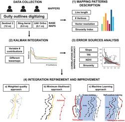
Scalable and transferable methods for generating reliable reference data for automated remote sensing approaches are crucial, especially for mapping complex Earth surface processes such as gully erosion in low-populated and inaccessible areas. As an alternative for the labour-intense in-situ authoritative mapping, collaborative approaches enable volunteers to generate redundant independent geoinformation by digitising Earth observation imagery. We face the challenge of mapping the complex gully outlines integrating multi-user contributions of the same gully network. Comparing Sentinel 2, Bing Aerial, and unoccupied aerial vehicle orthophoto base maps, we examine the volunteered geographic information process and multi-contribution integration using Kalman filtering and machine learning to segment a gully border in a remote area in northwestern Namibia. The Kalman filtering integrates the different lines finding a smoothed solution, and a Random Forest model is used to identify mapping conditions and terrain features as key predictors for evaluating contributors' digitising quality. Assessing results with expert-based reference data, we identify ten contributions as optimal, yielding root mean square distance values of 19.1 m, 15.9 m and 16.6 m, and variability of 2.0 m, 4.2 m and 3.8 m (root mean square distance standard deviation) for Sentinel 2, Bing Aerial, and unoccupied aerial vehicle orthophoto, respectively. Eliminating the lowest performing contributions for Sentinel 2 using a Random Forest regression-based quality indicator improves the accuracy by up to 35% in the root mean square distance compared to a random selection, and up to 54% compared to a supervised remote sensing classification. Results for Sentinel 2 show that low slope, low terrain ruggedness index, and high normalised difference vegetation index values are correlated to high spatial mapping deviations, with Pearson correlation coefficients of −0.61, −0.5, and 0.18, respectively. Our approach is a powerful alternative for authoritative mapping of morphologically complex environmental phenomena and can provide independent reference data for supervised automatic remote sensing analysis.

 求助内容:
求助内容: 应助结果提醒方式:


