Harshith Clifford Prince, C. M. Bhatt, Arijit Roy, Shanti Kumari, Akhilesh Singh Raghubanshi, Raghavendra Pratap Singh
{"title":"基于熵的北阿坎德邦喜马拉雅山山洪灾害绘图模型","authors":"Harshith Clifford Prince, C. M. Bhatt, Arijit Roy, Shanti Kumari, Akhilesh Singh Raghubanshi, Raghavendra Pratap Singh","doi":"10.1007/s12524-023-01797-8","DOIUrl":null,"url":null,"abstract":"<p>In light of recent hazards witnessed in Uttarakhand such as Kedarnath flash flood 2013, Chamoli flash flood 2021 and Maldevta flash flood 2022, flash flood hazard susceptibility (FFHS) mapping has become an important requirement for undertaking flood mitigation activities especially in mountainous regions. A number of approaches have been used for modelling flash flood susceptibility; however, ML-based techniques have shown significant potential. In the present study, the maximum entropy model (MAXENT model) approach was used to generate the FFHS map. Maxent is a presence of only model where the input used to train the model is the point locations of previous flash floods. About 100 field-based georeferenced points obtained from Uttarakhand State Disaster Management Authority were used to train the model whereas 29 for validating the modelled output. Terrain-derived parameters like elevation, slope, aspect, terrain wetness index, terrain ruggedness index, stream power index, sediment transport index, distance to river, distance to landslides, planform curve, profile curve and land cover were provided as input to the model. The model returned an area under the receiver operating characteristic curve value of 0.91 (91%). From the Jack-knife test, it was observed that distance to river, distance to landslide, elevation and land use/land cover are the four most critical conditioning factors for FFHS mapping. From the FFHS map, it is assessed that about five percentage of the study area falls under high and very high flash flood hazard potential classes. The very high-to-high hazard is mainly concentrated along the main stem of the Mandakini river.</p>","PeriodicalId":17510,"journal":{"name":"Journal of the Indian Society of Remote Sensing","volume":"28 1","pages":""},"PeriodicalIF":2.2000,"publicationDate":"2024-01-25","publicationTypes":"Journal Article","fieldsOfStudy":null,"isOpenAccess":false,"openAccessPdf":"","citationCount":"0","resultStr":"{\"title\":\"Entropy-Based Modelling for Flash Flood Hazard Mapping in Uttarakhand Himalaya\",\"authors\":\"Harshith Clifford Prince, C. M. Bhatt, Arijit Roy, Shanti Kumari, Akhilesh Singh Raghubanshi, Raghavendra Pratap Singh\",\"doi\":\"10.1007/s12524-023-01797-8\",\"DOIUrl\":null,\"url\":null,\"abstract\":\"<p>In light of recent hazards witnessed in Uttarakhand such as Kedarnath flash flood 2013, Chamoli flash flood 2021 and Maldevta flash flood 2022, flash flood hazard susceptibility (FFHS) mapping has become an important requirement for undertaking flood mitigation activities especially in mountainous regions. A number of approaches have been used for modelling flash flood susceptibility; however, ML-based techniques have shown significant potential. In the present study, the maximum entropy model (MAXENT model) approach was used to generate the FFHS map. Maxent is a presence of only model where the input used to train the model is the point locations of previous flash floods. About 100 field-based georeferenced points obtained from Uttarakhand State Disaster Management Authority were used to train the model whereas 29 for validating the modelled output. Terrain-derived parameters like elevation, slope, aspect, terrain wetness index, terrain ruggedness index, stream power index, sediment transport index, distance to river, distance to landslides, planform curve, profile curve and land cover were provided as input to the model. The model returned an area under the receiver operating characteristic curve value of 0.91 (91%). From the Jack-knife test, it was observed that distance to river, distance to landslide, elevation and land use/land cover are the four most critical conditioning factors for FFHS mapping. From the FFHS map, it is assessed that about five percentage of the study area falls under high and very high flash flood hazard potential classes. The very high-to-high hazard is mainly concentrated along the main stem of the Mandakini river.</p>\",\"PeriodicalId\":17510,\"journal\":{\"name\":\"Journal of the Indian Society of Remote Sensing\",\"volume\":\"28 1\",\"pages\":\"\"},\"PeriodicalIF\":2.2000,\"publicationDate\":\"2024-01-25\",\"publicationTypes\":\"Journal Article\",\"fieldsOfStudy\":null,\"isOpenAccess\":false,\"openAccessPdf\":\"\",\"citationCount\":\"0\",\"resultStr\":null,\"platform\":\"Semanticscholar\",\"paperid\":null,\"PeriodicalName\":\"Journal of the Indian Society of Remote Sensing\",\"FirstCategoryId\":\"5\",\"ListUrlMain\":\"https://doi.org/10.1007/s12524-023-01797-8\",\"RegionNum\":4,\"RegionCategory\":\"地球科学\",\"ArticlePicture\":[],\"TitleCN\":null,\"AbstractTextCN\":null,\"PMCID\":null,\"EPubDate\":\"\",\"PubModel\":\"\",\"JCR\":\"Q3\",\"JCRName\":\"ENVIRONMENTAL SCIENCES\",\"Score\":null,\"Total\":0}","platform":"Semanticscholar","paperid":null,"PeriodicalName":"Journal of the Indian Society of Remote Sensing","FirstCategoryId":"5","ListUrlMain":"https://doi.org/10.1007/s12524-023-01797-8","RegionNum":4,"RegionCategory":"地球科学","ArticlePicture":[],"TitleCN":null,"AbstractTextCN":null,"PMCID":null,"EPubDate":"","PubModel":"","JCR":"Q3","JCRName":"ENVIRONMENTAL SCIENCES","Score":null,"Total":0}
Entropy-Based Modelling for Flash Flood Hazard Mapping in Uttarakhand Himalaya
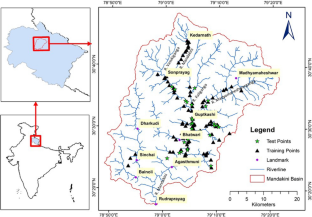
In light of recent hazards witnessed in Uttarakhand such as Kedarnath flash flood 2013, Chamoli flash flood 2021 and Maldevta flash flood 2022, flash flood hazard susceptibility (FFHS) mapping has become an important requirement for undertaking flood mitigation activities especially in mountainous regions. A number of approaches have been used for modelling flash flood susceptibility; however, ML-based techniques have shown significant potential. In the present study, the maximum entropy model (MAXENT model) approach was used to generate the FFHS map. Maxent is a presence of only model where the input used to train the model is the point locations of previous flash floods. About 100 field-based georeferenced points obtained from Uttarakhand State Disaster Management Authority were used to train the model whereas 29 for validating the modelled output. Terrain-derived parameters like elevation, slope, aspect, terrain wetness index, terrain ruggedness index, stream power index, sediment transport index, distance to river, distance to landslides, planform curve, profile curve and land cover were provided as input to the model. The model returned an area under the receiver operating characteristic curve value of 0.91 (91%). From the Jack-knife test, it was observed that distance to river, distance to landslide, elevation and land use/land cover are the four most critical conditioning factors for FFHS mapping. From the FFHS map, it is assessed that about five percentage of the study area falls under high and very high flash flood hazard potential classes. The very high-to-high hazard is mainly concentrated along the main stem of the Mandakini river.
期刊介绍:
The aims and scope of the Journal of the Indian Society of Remote Sensing are to help towards advancement, dissemination and application of the knowledge of Remote Sensing technology, which is deemed to include photo interpretation, photogrammetry, aerial photography, image processing, and other related technologies in the field of survey, planning and management of natural resources and other areas of application where the technology is considered to be appropriate, to promote interaction among all persons, bodies, institutions (private and/or state-owned) and industries interested in achieving advancement, dissemination and application of the technology, to encourage and undertake research in remote sensing and related technologies and to undertake and execute all acts which shall promote all or any of the aims and objectives of the Indian Society of Remote Sensing.
 求助内容:
求助内容: 应助结果提醒方式:


