Adekunle Ayodotun Osinowo, Samuel Olatunde Popoola
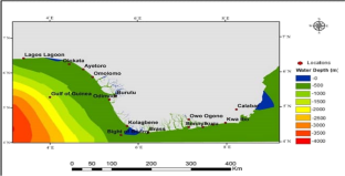
{"title":"尼日利亚沿岸海域状况的统计评估","authors":"Adekunle Ayodotun Osinowo, Samuel Olatunde Popoola","doi":"10.1007/s11852-023-01014-1","DOIUrl":null,"url":null,"abstract":"<p>Statistical evaluation of sea’s state is essential for the design and managements of marine structures, operations, shipping and navigation security. For the purpose of coastal navigation, little to no research has been done on the state of the sea along the Nigerian coast. Understanding the local sea’s state can help to lessen the frequency of incidents brought on by ships capsizing. In order to notify users of probable areas where vessel overturning may occur, this study therefore employs the warning and prediction services system created and developed by the Indian National Centre for Ocean Information Services (INCOIS). The system bases its warning advisory on the Boat Safety Index (BSI), a newly developed index with a sufficient threshold. Furthermore, this study investigates the statistical properties of the sea’s state along the Nigerian coast, using daily significant wave height (SWH) and 10 m wind speed (u) data spanning 37 years (1980–2016). The Douglas smooth (wavelet) sea’s state classification prevailed in both cases in the sea. It occurred more in the dry season than in the rainy season. The Douglas smooth (wavelets) sea also prevailed in all months of the year except in August, when the Douglas slight sea had higher occurrences. A spatial analysis using SWH showed that Douglas calm seas are predominant in the eastern waters of the study region. The majority of the study area's waters are dominated by the Douglas smooth (wavelets) sea, which is especially prevalent in the area around Lagos Lagoon. In the western coast of the study area, the Douglas slight sea had the highest frequencies. Very low occurrences of the Douglas moderate and rough seas were observed over the research area. Additionally, a spatial analysis using u revealed that the Douglas smooth (wavelets) sea prevailed in the eastern coast of the study area. The Douglas light and moderate seas increased offshore. In the far western coast of the study location, the Douglas rough to high seas showed very rare occurrences. In all, very little or no occurrence of the Douglas rough to phenomenal seas was observed. Insignificant trends exist for the Douglas smooth (wavelets) sea over the study area. The Boat Safety Index used to evaluate the research location showed that it is considered safe for coastal sailing.</p>","PeriodicalId":48909,"journal":{"name":"Journal of Coastal Conservation","volume":"157 1","pages":""},"PeriodicalIF":1.9000,"publicationDate":"2024-01-11","publicationTypes":"Journal Article","fieldsOfStudy":null,"isOpenAccess":false,"openAccessPdf":"","citationCount":"0","resultStr":"{\"title\":\"Statistical evaluations of sea’s state along the Nigerian coast\",\"authors\":\"Adekunle Ayodotun Osinowo, Samuel Olatunde Popoola\",\"doi\":\"10.1007/s11852-023-01014-1\",\"DOIUrl\":null,\"url\":null,\"abstract\":\"<p>Statistical evaluation of sea’s state is essential for the design and managements of marine structures, operations, shipping and navigation security. For the purpose of coastal navigation, little to no research has been done on the state of the sea along the Nigerian coast. Understanding the local sea’s state can help to lessen the frequency of incidents brought on by ships capsizing. In order to notify users of probable areas where vessel overturning may occur, this study therefore employs the warning and prediction services system created and developed by the Indian National Centre for Ocean Information Services (INCOIS). The system bases its warning advisory on the Boat Safety Index (BSI), a newly developed index with a sufficient threshold. Furthermore, this study investigates the statistical properties of the sea’s state along the Nigerian coast, using daily significant wave height (SWH) and 10 m wind speed (u) data spanning 37 years (1980–2016). The Douglas smooth (wavelet) sea’s state classification prevailed in both cases in the sea. It occurred more in the dry season than in the rainy season. The Douglas smooth (wavelets) sea also prevailed in all months of the year except in August, when the Douglas slight sea had higher occurrences. A spatial analysis using SWH showed that Douglas calm seas are predominant in the eastern waters of the study region. The majority of the study area's waters are dominated by the Douglas smooth (wavelets) sea, which is especially prevalent in the area around Lagos Lagoon. In the western coast of the study area, the Douglas slight sea had the highest frequencies. Very low occurrences of the Douglas moderate and rough seas were observed over the research area. Additionally, a spatial analysis using u revealed that the Douglas smooth (wavelets) sea prevailed in the eastern coast of the study area. The Douglas light and moderate seas increased offshore. In the far western coast of the study location, the Douglas rough to high seas showed very rare occurrences. In all, very little or no occurrence of the Douglas rough to phenomenal seas was observed. Insignificant trends exist for the Douglas smooth (wavelets) sea over the study area. The Boat Safety Index used to evaluate the research location showed that it is considered safe for coastal sailing.</p>\",\"PeriodicalId\":48909,\"journal\":{\"name\":\"Journal of Coastal Conservation\",\"volume\":\"157 1\",\"pages\":\"\"},\"PeriodicalIF\":1.9000,\"publicationDate\":\"2024-01-11\",\"publicationTypes\":\"Journal Article\",\"fieldsOfStudy\":null,\"isOpenAccess\":false,\"openAccessPdf\":\"\",\"citationCount\":\"0\",\"resultStr\":null,\"platform\":\"Semanticscholar\",\"paperid\":null,\"PeriodicalName\":\"Journal of Coastal Conservation\",\"FirstCategoryId\":\"93\",\"ListUrlMain\":\"https://doi.org/10.1007/s11852-023-01014-1\",\"RegionNum\":4,\"RegionCategory\":\"环境科学与生态学\",\"ArticlePicture\":[],\"TitleCN\":null,\"AbstractTextCN\":null,\"PMCID\":null,\"EPubDate\":\"\",\"PubModel\":\"\",\"JCR\":\"Q4\",\"JCRName\":\"ENVIRONMENTAL SCIENCES\",\"Score\":null,\"Total\":0}","platform":"Semanticscholar","paperid":null,"PeriodicalName":"Journal of Coastal Conservation","FirstCategoryId":"93","ListUrlMain":"https://doi.org/10.1007/s11852-023-01014-1","RegionNum":4,"RegionCategory":"环境科学与生态学","ArticlePicture":[],"TitleCN":null,"AbstractTextCN":null,"PMCID":null,"EPubDate":"","PubModel":"","JCR":"Q4","JCRName":"ENVIRONMENTAL SCIENCES","Score":null,"Total":0}
Statistical evaluations of sea’s state along the Nigerian coast
Statistical evaluation of sea’s state is essential for the design and managements of marine structures, operations, shipping and navigation security. For the purpose of coastal navigation, little to no research has been done on the state of the sea along the Nigerian coast. Understanding the local sea’s state can help to lessen the frequency of incidents brought on by ships capsizing. In order to notify users of probable areas where vessel overturning may occur, this study therefore employs the warning and prediction services system created and developed by the Indian National Centre for Ocean Information Services (INCOIS). The system bases its warning advisory on the Boat Safety Index (BSI), a newly developed index with a sufficient threshold. Furthermore, this study investigates the statistical properties of the sea’s state along the Nigerian coast, using daily significant wave height (SWH) and 10 m wind speed (u) data spanning 37 years (1980–2016). The Douglas smooth (wavelet) sea’s state classification prevailed in both cases in the sea. It occurred more in the dry season than in the rainy season. The Douglas smooth (wavelets) sea also prevailed in all months of the year except in August, when the Douglas slight sea had higher occurrences. A spatial analysis using SWH showed that Douglas calm seas are predominant in the eastern waters of the study region. The majority of the study area's waters are dominated by the Douglas smooth (wavelets) sea, which is especially prevalent in the area around Lagos Lagoon. In the western coast of the study area, the Douglas slight sea had the highest frequencies. Very low occurrences of the Douglas moderate and rough seas were observed over the research area. Additionally, a spatial analysis using u revealed that the Douglas smooth (wavelets) sea prevailed in the eastern coast of the study area. The Douglas light and moderate seas increased offshore. In the far western coast of the study location, the Douglas rough to high seas showed very rare occurrences. In all, very little or no occurrence of the Douglas rough to phenomenal seas was observed. Insignificant trends exist for the Douglas smooth (wavelets) sea over the study area. The Boat Safety Index used to evaluate the research location showed that it is considered safe for coastal sailing.
期刊介绍:
The Journal of Coastal Conservation is a scientific journal for the dissemination of both theoretical and applied research on integrated and sustainable management of the terrestrial, coastal and marine environmental interface.
A thorough understanding of both the physical and the human sciences is important to the study of the spatial patterns and processes observed in terrestrial, coastal and marine systems set in the context of past, present and future social and economic developments. This includes multidisciplinary and integrated knowledge and understanding of: physical geography, coastal geomorphology, sediment dynamics, hydrodynamics, soil science, hydrology, plant and animal ecology, vegetation science, biogeography, landscape ecology, recreation and tourism studies, urban and human ecology, coastal engineering and spatial planning, coastal zone management, and marine resource management.
 求助内容:
求助内容: 应助结果提醒方式:


