{"title":"利用高分辨率数据集和谷歌地球引擎评估气候变化对孟加拉国红树林的影响","authors":"Bijay Halder, Paulo Pereira","doi":"10.1007/s11852-023-01020-3","DOIUrl":null,"url":null,"abstract":"<p>Mangrove forests protect the coastal environment and reduce shoreline shift, deforestation, and flood inundation. Global sea-level rise (SLR) and Bay of Bengal (BoB) cyclonic effects in the Bay of Bengal (BOB) is gradually trigger environmental degradation, flood inundation, and mangrove deforestation. Bangladesh Sundarbans are also affected by SLR and flood inundation every year. Sundarban Biosphere Reserve (SBR) is vulnerable because of extreme climatic conditions and anthropogenic activities. Those environmental effects are measurable through remote sensing (RS) and GIS approaches. Three types of satellite data, like Landsat 8 OLI/TIRS, Sentinel-1 GRD and Sentinel-2 MSI datasets, were applied with the Google Earth Engine (GEE) cloud computing platform. Around 11.57 km<sup>2</sup> of mangrove forest will be lost from 2017 to 2022. The cyclone effects are located twice, like Mora (2017) and Sitrang (2022), while affected landforms are 77.15 km<sup>2</sup> (1.38%) and 218.75 km<sup>2</sup> (3.93%), respectively. Vegetation monitoring indices are also good outcomes for forest land change assessment over the examined area. Forest degradation index (FDI) values were observed in 1950 (2017) and 2620 (2022), which mentioned that north, middle, and near-shore areas are affected lands. Some adaptation planning implemented by the local government includes future disaster management, early warning system, reduction of river bank erosion, restricted forest area, and mangrove plantation. Putney Island, Bangabandhu Island, and Dimer Island are the most deforested lands. These investigation outcomes are helpful for future disaster planning, coastal environment management, awareness, mangrove forest restoration, and novel approaches to protect the coastal environment with healthier improvement policies.</p>","PeriodicalId":48909,"journal":{"name":"Journal of Coastal Conservation","volume":"31 1","pages":""},"PeriodicalIF":1.9000,"publicationDate":"2024-01-08","publicationTypes":"Journal Article","fieldsOfStudy":null,"isOpenAccess":false,"openAccessPdf":"","citationCount":"0","resultStr":"{\"title\":\"Climate change impacts assessment on Bangladesh Mangrove Forest using high-resolution datasets and Google Earth Engine\",\"authors\":\"Bijay Halder, Paulo Pereira\",\"doi\":\"10.1007/s11852-023-01020-3\",\"DOIUrl\":null,\"url\":null,\"abstract\":\"<p>Mangrove forests protect the coastal environment and reduce shoreline shift, deforestation, and flood inundation. Global sea-level rise (SLR) and Bay of Bengal (BoB) cyclonic effects in the Bay of Bengal (BOB) is gradually trigger environmental degradation, flood inundation, and mangrove deforestation. Bangladesh Sundarbans are also affected by SLR and flood inundation every year. Sundarban Biosphere Reserve (SBR) is vulnerable because of extreme climatic conditions and anthropogenic activities. Those environmental effects are measurable through remote sensing (RS) and GIS approaches. Three types of satellite data, like Landsat 8 OLI/TIRS, Sentinel-1 GRD and Sentinel-2 MSI datasets, were applied with the Google Earth Engine (GEE) cloud computing platform. Around 11.57 km<sup>2</sup> of mangrove forest will be lost from 2017 to 2022. The cyclone effects are located twice, like Mora (2017) and Sitrang (2022), while affected landforms are 77.15 km<sup>2</sup> (1.38%) and 218.75 km<sup>2</sup> (3.93%), respectively. Vegetation monitoring indices are also good outcomes for forest land change assessment over the examined area. Forest degradation index (FDI) values were observed in 1950 (2017) and 2620 (2022), which mentioned that north, middle, and near-shore areas are affected lands. Some adaptation planning implemented by the local government includes future disaster management, early warning system, reduction of river bank erosion, restricted forest area, and mangrove plantation. Putney Island, Bangabandhu Island, and Dimer Island are the most deforested lands. These investigation outcomes are helpful for future disaster planning, coastal environment management, awareness, mangrove forest restoration, and novel approaches to protect the coastal environment with healthier improvement policies.</p>\",\"PeriodicalId\":48909,\"journal\":{\"name\":\"Journal of Coastal Conservation\",\"volume\":\"31 1\",\"pages\":\"\"},\"PeriodicalIF\":1.9000,\"publicationDate\":\"2024-01-08\",\"publicationTypes\":\"Journal Article\",\"fieldsOfStudy\":null,\"isOpenAccess\":false,\"openAccessPdf\":\"\",\"citationCount\":\"0\",\"resultStr\":null,\"platform\":\"Semanticscholar\",\"paperid\":null,\"PeriodicalName\":\"Journal of Coastal Conservation\",\"FirstCategoryId\":\"93\",\"ListUrlMain\":\"https://doi.org/10.1007/s11852-023-01020-3\",\"RegionNum\":4,\"RegionCategory\":\"环境科学与生态学\",\"ArticlePicture\":[],\"TitleCN\":null,\"AbstractTextCN\":null,\"PMCID\":null,\"EPubDate\":\"\",\"PubModel\":\"\",\"JCR\":\"Q4\",\"JCRName\":\"ENVIRONMENTAL SCIENCES\",\"Score\":null,\"Total\":0}","platform":"Semanticscholar","paperid":null,"PeriodicalName":"Journal of Coastal Conservation","FirstCategoryId":"93","ListUrlMain":"https://doi.org/10.1007/s11852-023-01020-3","RegionNum":4,"RegionCategory":"环境科学与生态学","ArticlePicture":[],"TitleCN":null,"AbstractTextCN":null,"PMCID":null,"EPubDate":"","PubModel":"","JCR":"Q4","JCRName":"ENVIRONMENTAL SCIENCES","Score":null,"Total":0}
Climate change impacts assessment on Bangladesh Mangrove Forest using high-resolution datasets and Google Earth Engine
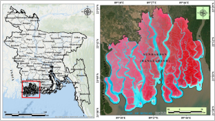
Mangrove forests protect the coastal environment and reduce shoreline shift, deforestation, and flood inundation. Global sea-level rise (SLR) and Bay of Bengal (BoB) cyclonic effects in the Bay of Bengal (BOB) is gradually trigger environmental degradation, flood inundation, and mangrove deforestation. Bangladesh Sundarbans are also affected by SLR and flood inundation every year. Sundarban Biosphere Reserve (SBR) is vulnerable because of extreme climatic conditions and anthropogenic activities. Those environmental effects are measurable through remote sensing (RS) and GIS approaches. Three types of satellite data, like Landsat 8 OLI/TIRS, Sentinel-1 GRD and Sentinel-2 MSI datasets, were applied with the Google Earth Engine (GEE) cloud computing platform. Around 11.57 km2 of mangrove forest will be lost from 2017 to 2022. The cyclone effects are located twice, like Mora (2017) and Sitrang (2022), while affected landforms are 77.15 km2 (1.38%) and 218.75 km2 (3.93%), respectively. Vegetation monitoring indices are also good outcomes for forest land change assessment over the examined area. Forest degradation index (FDI) values were observed in 1950 (2017) and 2620 (2022), which mentioned that north, middle, and near-shore areas are affected lands. Some adaptation planning implemented by the local government includes future disaster management, early warning system, reduction of river bank erosion, restricted forest area, and mangrove plantation. Putney Island, Bangabandhu Island, and Dimer Island are the most deforested lands. These investigation outcomes are helpful for future disaster planning, coastal environment management, awareness, mangrove forest restoration, and novel approaches to protect the coastal environment with healthier improvement policies.
期刊介绍:
The Journal of Coastal Conservation is a scientific journal for the dissemination of both theoretical and applied research on integrated and sustainable management of the terrestrial, coastal and marine environmental interface.
A thorough understanding of both the physical and the human sciences is important to the study of the spatial patterns and processes observed in terrestrial, coastal and marine systems set in the context of past, present and future social and economic developments. This includes multidisciplinary and integrated knowledge and understanding of: physical geography, coastal geomorphology, sediment dynamics, hydrodynamics, soil science, hydrology, plant and animal ecology, vegetation science, biogeography, landscape ecology, recreation and tourism studies, urban and human ecology, coastal engineering and spatial planning, coastal zone management, and marine resource management.
 求助内容:
求助内容: 应助结果提醒方式:


