James Tricker, Claire Wright, Spencer Rose, Jeanine Rhemtulla, Trevor Lantz, Eric Higgs
{"title":"利用机器学习评估从斜射图像中提取的地理坐标土地覆盖数据的准确性","authors":"James Tricker, Claire Wright, Spencer Rose, Jeanine Rhemtulla, Trevor Lantz, Eric Higgs","doi":"10.1002/rse2.379","DOIUrl":null,"url":null,"abstract":"Repeat photography offers distinctive insights into ecological change, with ground-based oblique photographs often predating early aerial images by decades. However, the oblique angle of the photographs presents challenges for extracting and analyzing ecological information using traditional remote sensing approaches. Several innovative methods have been developed for analyzing repeat photographs, but none offer a comprehensive end-to-end workflow incorporating image classification and georeferencing to produce quantifiable landcover data. In this paper, we provide an overview of two new tools, an automated deep learning classifier and intuitive georeferencing tool, and describe how they are used to derive landcover data from 19 images associated with the Mountain Legacy Project, a research team that works with the world's largest collection of systematic high-resolution historic mountain photographs. We then combined these data to produce a contemporary landcover map for a study area in Jasper National Park, Canada. We assessed georeferencing accuracy by calculating the root-mean-square error and mean displacement for a subset of the images, which was 4.6 and 3.7 m, respectively. Overall classification accuracy of the landcover map produced from oblique images was 68%, which was comparable to landcover data produced from aerial imagery using a conventional classification method. The new workflow advances the use of repeat photographs for yielding quantitative landcover data. It has several advantages over existing methods including the ability to produce quick and consistent image classifications with little human input, and accurately georeference and combine these data to generate landcover maps for large areas.","PeriodicalId":21132,"journal":{"name":"Remote Sensing in Ecology and Conservation","volume":"29 1","pages":""},"PeriodicalIF":3.9000,"publicationDate":"2024-01-04","publicationTypes":"Journal Article","fieldsOfStudy":null,"isOpenAccess":false,"openAccessPdf":"","citationCount":"0","resultStr":"{\"title\":\"Assessing the accuracy of georeferenced landcover data derived from oblique imagery using machine learning\",\"authors\":\"James Tricker, Claire Wright, Spencer Rose, Jeanine Rhemtulla, Trevor Lantz, Eric Higgs\",\"doi\":\"10.1002/rse2.379\",\"DOIUrl\":null,\"url\":null,\"abstract\":\"Repeat photography offers distinctive insights into ecological change, with ground-based oblique photographs often predating early aerial images by decades. However, the oblique angle of the photographs presents challenges for extracting and analyzing ecological information using traditional remote sensing approaches. Several innovative methods have been developed for analyzing repeat photographs, but none offer a comprehensive end-to-end workflow incorporating image classification and georeferencing to produce quantifiable landcover data. In this paper, we provide an overview of two new tools, an automated deep learning classifier and intuitive georeferencing tool, and describe how they are used to derive landcover data from 19 images associated with the Mountain Legacy Project, a research team that works with the world's largest collection of systematic high-resolution historic mountain photographs. We then combined these data to produce a contemporary landcover map for a study area in Jasper National Park, Canada. We assessed georeferencing accuracy by calculating the root-mean-square error and mean displacement for a subset of the images, which was 4.6 and 3.7 m, respectively. Overall classification accuracy of the landcover map produced from oblique images was 68%, which was comparable to landcover data produced from aerial imagery using a conventional classification method. The new workflow advances the use of repeat photographs for yielding quantitative landcover data. It has several advantages over existing methods including the ability to produce quick and consistent image classifications with little human input, and accurately georeference and combine these data to generate landcover maps for large areas.\",\"PeriodicalId\":21132,\"journal\":{\"name\":\"Remote Sensing in Ecology and Conservation\",\"volume\":\"29 1\",\"pages\":\"\"},\"PeriodicalIF\":3.9000,\"publicationDate\":\"2024-01-04\",\"publicationTypes\":\"Journal Article\",\"fieldsOfStudy\":null,\"isOpenAccess\":false,\"openAccessPdf\":\"\",\"citationCount\":\"0\",\"resultStr\":null,\"platform\":\"Semanticscholar\",\"paperid\":null,\"PeriodicalName\":\"Remote Sensing in Ecology and Conservation\",\"FirstCategoryId\":\"93\",\"ListUrlMain\":\"https://doi.org/10.1002/rse2.379\",\"RegionNum\":2,\"RegionCategory\":\"环境科学与生态学\",\"ArticlePicture\":[],\"TitleCN\":null,\"AbstractTextCN\":null,\"PMCID\":null,\"EPubDate\":\"\",\"PubModel\":\"\",\"JCR\":\"Q1\",\"JCRName\":\"ECOLOGY\",\"Score\":null,\"Total\":0}","platform":"Semanticscholar","paperid":null,"PeriodicalName":"Remote Sensing in Ecology and Conservation","FirstCategoryId":"93","ListUrlMain":"https://doi.org/10.1002/rse2.379","RegionNum":2,"RegionCategory":"环境科学与生态学","ArticlePicture":[],"TitleCN":null,"AbstractTextCN":null,"PMCID":null,"EPubDate":"","PubModel":"","JCR":"Q1","JCRName":"ECOLOGY","Score":null,"Total":0}
Assessing the accuracy of georeferenced landcover data derived from oblique imagery using machine learning
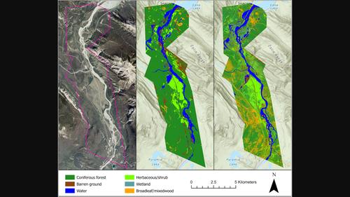
Repeat photography offers distinctive insights into ecological change, with ground-based oblique photographs often predating early aerial images by decades. However, the oblique angle of the photographs presents challenges for extracting and analyzing ecological information using traditional remote sensing approaches. Several innovative methods have been developed for analyzing repeat photographs, but none offer a comprehensive end-to-end workflow incorporating image classification and georeferencing to produce quantifiable landcover data. In this paper, we provide an overview of two new tools, an automated deep learning classifier and intuitive georeferencing tool, and describe how they are used to derive landcover data from 19 images associated with the Mountain Legacy Project, a research team that works with the world's largest collection of systematic high-resolution historic mountain photographs. We then combined these data to produce a contemporary landcover map for a study area in Jasper National Park, Canada. We assessed georeferencing accuracy by calculating the root-mean-square error and mean displacement for a subset of the images, which was 4.6 and 3.7 m, respectively. Overall classification accuracy of the landcover map produced from oblique images was 68%, which was comparable to landcover data produced from aerial imagery using a conventional classification method. The new workflow advances the use of repeat photographs for yielding quantitative landcover data. It has several advantages over existing methods including the ability to produce quick and consistent image classifications with little human input, and accurately georeference and combine these data to generate landcover maps for large areas.
期刊介绍:
emote Sensing in Ecology and Conservation provides a forum for rapid, peer-reviewed publication of novel, multidisciplinary research at the interface between remote sensing science and ecology and conservation. The journal prioritizes findings that advance the scientific basis of ecology and conservation, promoting the development of remote-sensing based methods relevant to the management of land use and biological systems at all levels, from populations and species to ecosystems and biomes. The journal defines remote sensing in its broadest sense, including data acquisition by hand-held and fixed ground-based sensors, such as camera traps and acoustic recorders, and sensors on airplanes and satellites. The intended journal’s audience includes ecologists, conservation scientists, policy makers, managers of terrestrial and aquatic systems, remote sensing scientists, and students.
Remote Sensing in Ecology and Conservation is a fully open access journal from Wiley and the Zoological Society of London. Remote sensing has enormous potential as to provide information on the state of, and pressures on, biological diversity and ecosystem services, at multiple spatial and temporal scales. This new publication provides a forum for multidisciplinary research in remote sensing science, ecological research and conservation science.