Sheikh Mohammed Rabiul Alam, Mohammad Shawkat Hossain
{"title":"使用水指数方法,利用多时区大地遥感卫星 8 号图像绘制周期性淹没盐沼地植被和生态区划图","authors":"Sheikh Mohammed Rabiul Alam, Mohammad Shawkat Hossain","doi":"10.1007/s11852-023-01019-w","DOIUrl":null,"url":null,"abstract":"<p>Saltmarsh land-cover (SLC) ecosystems, composed of unvegetated mudflats, saltmarshes, mangroves, and/or seagrass communities, are vulnerable to climate-induced impacts, such as sea level rise. Extracting a seamless and consistent waterline from satellite imagery is a major challenge because of environmental factors, such as turbidity, water depth and multiple types of underwater vegetation cover that introduce noise in the extraction of information. Hence, a water index, derived from multi-temporal Landsat 8 (OLI) data, acquired under different tides is proposed for mapping land-water across SLC wetlands by tracking waterlines. This provided inundation maps and defined eco-zones to specify south-eastern Bangladesh wetland composition. The NDWI_1 (McFeeters’s water index) applied to 42 OLI images and derived land-water difference maps generated inundation gradient maps with an overall classification accuracy of 87.8%. The simple intersection and union of region-of-interests extracted from the tide heights above the mean low-water springs enabled the mapping of four categories of wetland composition based on hydroperiods: a) irregularly inundated (II), regularly inundated (RI), irregularly exposed (IE; high floodplain), and subtidal (river bed and deep water sea). For all of the three study sites, mangrove, seagrass, non-mangrove and agriculture were all prominent on the IE eco-zone, while only saltmarsh was dominant on the II eco-zone. These maps of SLC wetland will enrich previous concepts of eco-zonation models that include salinity, erosion, accretion and rate of sea level rise as factors, suggesting that inundation extent and tidal phase complexities should be considered in the remote sensing of SLC composition for improved models of SLC vegetation response to climate change.</p>","PeriodicalId":48909,"journal":{"name":"Journal of Coastal Conservation","volume":"48 5 1","pages":""},"PeriodicalIF":1.9000,"publicationDate":"2024-01-05","publicationTypes":"Journal Article","fieldsOfStudy":null,"isOpenAccess":false,"openAccessPdf":"","citationCount":"0","resultStr":"{\"title\":\"Using a water index approach to mapping periodically inundated saltmarsh land-cover vegetation and eco-zonation using multi-temporal Landsat 8 imagery\",\"authors\":\"Sheikh Mohammed Rabiul Alam, Mohammad Shawkat Hossain\",\"doi\":\"10.1007/s11852-023-01019-w\",\"DOIUrl\":null,\"url\":null,\"abstract\":\"<p>Saltmarsh land-cover (SLC) ecosystems, composed of unvegetated mudflats, saltmarshes, mangroves, and/or seagrass communities, are vulnerable to climate-induced impacts, such as sea level rise. Extracting a seamless and consistent waterline from satellite imagery is a major challenge because of environmental factors, such as turbidity, water depth and multiple types of underwater vegetation cover that introduce noise in the extraction of information. Hence, a water index, derived from multi-temporal Landsat 8 (OLI) data, acquired under different tides is proposed for mapping land-water across SLC wetlands by tracking waterlines. This provided inundation maps and defined eco-zones to specify south-eastern Bangladesh wetland composition. The NDWI_1 (McFeeters’s water index) applied to 42 OLI images and derived land-water difference maps generated inundation gradient maps with an overall classification accuracy of 87.8%. The simple intersection and union of region-of-interests extracted from the tide heights above the mean low-water springs enabled the mapping of four categories of wetland composition based on hydroperiods: a) irregularly inundated (II), regularly inundated (RI), irregularly exposed (IE; high floodplain), and subtidal (river bed and deep water sea). For all of the three study sites, mangrove, seagrass, non-mangrove and agriculture were all prominent on the IE eco-zone, while only saltmarsh was dominant on the II eco-zone. These maps of SLC wetland will enrich previous concepts of eco-zonation models that include salinity, erosion, accretion and rate of sea level rise as factors, suggesting that inundation extent and tidal phase complexities should be considered in the remote sensing of SLC composition for improved models of SLC vegetation response to climate change.</p>\",\"PeriodicalId\":48909,\"journal\":{\"name\":\"Journal of Coastal Conservation\",\"volume\":\"48 5 1\",\"pages\":\"\"},\"PeriodicalIF\":1.9000,\"publicationDate\":\"2024-01-05\",\"publicationTypes\":\"Journal Article\",\"fieldsOfStudy\":null,\"isOpenAccess\":false,\"openAccessPdf\":\"\",\"citationCount\":\"0\",\"resultStr\":null,\"platform\":\"Semanticscholar\",\"paperid\":null,\"PeriodicalName\":\"Journal of Coastal Conservation\",\"FirstCategoryId\":\"93\",\"ListUrlMain\":\"https://doi.org/10.1007/s11852-023-01019-w\",\"RegionNum\":4,\"RegionCategory\":\"环境科学与生态学\",\"ArticlePicture\":[],\"TitleCN\":null,\"AbstractTextCN\":null,\"PMCID\":null,\"EPubDate\":\"\",\"PubModel\":\"\",\"JCR\":\"Q4\",\"JCRName\":\"ENVIRONMENTAL SCIENCES\",\"Score\":null,\"Total\":0}","platform":"Semanticscholar","paperid":null,"PeriodicalName":"Journal of Coastal Conservation","FirstCategoryId":"93","ListUrlMain":"https://doi.org/10.1007/s11852-023-01019-w","RegionNum":4,"RegionCategory":"环境科学与生态学","ArticlePicture":[],"TitleCN":null,"AbstractTextCN":null,"PMCID":null,"EPubDate":"","PubModel":"","JCR":"Q4","JCRName":"ENVIRONMENTAL SCIENCES","Score":null,"Total":0}
引用次数: 0
摘要
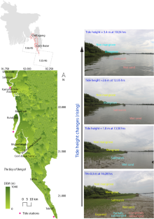
由无植被泥滩、盐沼、红树林和/或海草群落组成的盐沼地被(SLC)生态系统很容易受到海平面上升等气候因素的影响。由于浊度、水深和多种水下植被覆盖等环境因素会在信息提取过程中产生噪声,因此从卫星图像中提取无缝一致的水线是一项重大挑战。因此,我们提出了一种从不同潮汐条件下获取的多时相大地遥感卫星 8 号(OLI)数据中得出的水指数,通过跟踪水线来绘制整个南亚大陆架湿地的水陆图。这提供了淹没地图,并定义了生态区,以明确孟加拉国东南部湿地的组成。将 NDWI_1(麦克菲特斯水指数)应用于 42 幅 OLI 图像和衍生的陆地-水差异图,生成了淹没梯度图,总体分类准确率为 87.8%。通过对从平均低水位涌泉以上的潮汐高度提取的兴趣区进行简单的交叉和合并,可绘制出基于水文周期的四类湿地组成图:a)不规则淹没(II)、规则淹没(RI)、不规则裸露(IE;高洪泛区)和潮下带(河床和深水海域)。在所有三个研究地点中,红树林、海草、非红树林和农业在 IE 生态区都很突出,而只有盐沼在 II 生态区占主导地位。这些南大洋湿地地图将丰富以往生态区划模型的概念,包括盐度、侵蚀、增生和海平面上升速度等因素,表明在遥感南大洋湿地组成时应考虑淹没范围和潮汐相位的复杂性,以改进南大洋湿地植被对气候变化的响应模型。
Using a water index approach to mapping periodically inundated saltmarsh land-cover vegetation and eco-zonation using multi-temporal Landsat 8 imagery
Saltmarsh land-cover (SLC) ecosystems, composed of unvegetated mudflats, saltmarshes, mangroves, and/or seagrass communities, are vulnerable to climate-induced impacts, such as sea level rise. Extracting a seamless and consistent waterline from satellite imagery is a major challenge because of environmental factors, such as turbidity, water depth and multiple types of underwater vegetation cover that introduce noise in the extraction of information. Hence, a water index, derived from multi-temporal Landsat 8 (OLI) data, acquired under different tides is proposed for mapping land-water across SLC wetlands by tracking waterlines. This provided inundation maps and defined eco-zones to specify south-eastern Bangladesh wetland composition. The NDWI_1 (McFeeters’s water index) applied to 42 OLI images and derived land-water difference maps generated inundation gradient maps with an overall classification accuracy of 87.8%. The simple intersection and union of region-of-interests extracted from the tide heights above the mean low-water springs enabled the mapping of four categories of wetland composition based on hydroperiods: a) irregularly inundated (II), regularly inundated (RI), irregularly exposed (IE; high floodplain), and subtidal (river bed and deep water sea). For all of the three study sites, mangrove, seagrass, non-mangrove and agriculture were all prominent on the IE eco-zone, while only saltmarsh was dominant on the II eco-zone. These maps of SLC wetland will enrich previous concepts of eco-zonation models that include salinity, erosion, accretion and rate of sea level rise as factors, suggesting that inundation extent and tidal phase complexities should be considered in the remote sensing of SLC composition for improved models of SLC vegetation response to climate change.
期刊介绍:
The Journal of Coastal Conservation is a scientific journal for the dissemination of both theoretical and applied research on integrated and sustainable management of the terrestrial, coastal and marine environmental interface.
A thorough understanding of both the physical and the human sciences is important to the study of the spatial patterns and processes observed in terrestrial, coastal and marine systems set in the context of past, present and future social and economic developments. This includes multidisciplinary and integrated knowledge and understanding of: physical geography, coastal geomorphology, sediment dynamics, hydrodynamics, soil science, hydrology, plant and animal ecology, vegetation science, biogeography, landscape ecology, recreation and tourism studies, urban and human ecology, coastal engineering and spatial planning, coastal zone management, and marine resource management.
 求助内容:
求助内容: 应助结果提醒方式:


