{"title":"伊朗洛雷斯坦省地质遗产复原力评估促进地质保护规划","authors":"Fatemeh Moradipour, Anvar Moradi, Mojtaba Yamani","doi":"10.1007/s12371-023-00909-7","DOIUrl":null,"url":null,"abstract":"<p>This study is an initial attempt to introduce the concept of geoheritage resilience, which refers to the capacity of a geosite and its system to absorb, adapt, or resist disturbances, and to consider it in geoconservation planning. Assessing the resilience of geoheritage sites is crucial for managing, protecting and developing sustainable geotourism that requires a specific approach and methodology. Therefore, this research aims to propose a comprehensive method based on criteria and indicators to measure the resilience of geoheritage sites and implement it in the most significant geosites of Lorestan province through literature review and fieldwork. The proposed method is based on 5 criteria and 22 indicators. Each indicator is measured based on 5 parameters and calculations are performed using the corresponding equations. The results of the geoheritage resilience assessment, using the proposed method, indicate that various geological, hydroclimatic, ecological, anthropogenic, and geotourism disturbances have led to a reduction the resilience of the geosites studied. According to the results, Calder Cave and Shirz Canyon geosites have a high level of resilience with final scores of 65.62 and 62.62, respectively. In contrast, Bisheh Waterfall and Pol-e Dokhtar Lakes have a low level of resilience with scores of 46.73 and 35.51, respectively. These two geosites are affected by natural and human disturbances, which require effective management, protection, and improvement of their resilience levels. This study has also provided a basic conceptual model to illustrate the planning process for enhancing and promoting geoheritage resilience through geoconservation planning. Given the importance of geoheritage and the potential threats, it is very important to pay attention to the concept of resilience and the measurement of geoheritage resilience in geoconservation planning for sustainable scientific, educational and geotourism use.</p>","PeriodicalId":48924,"journal":{"name":"Geoheritage","volume":"9 1","pages":""},"PeriodicalIF":2.4000,"publicationDate":"2023-12-19","publicationTypes":"Journal Article","fieldsOfStudy":null,"isOpenAccess":false,"openAccessPdf":"","citationCount":"0","resultStr":"{\"title\":\"Geoheritage Resilience Assessment for Geoconservation Planning in Lorestan Province, Iran\",\"authors\":\"Fatemeh Moradipour, Anvar Moradi, Mojtaba Yamani\",\"doi\":\"10.1007/s12371-023-00909-7\",\"DOIUrl\":null,\"url\":null,\"abstract\":\"<p>This study is an initial attempt to introduce the concept of geoheritage resilience, which refers to the capacity of a geosite and its system to absorb, adapt, or resist disturbances, and to consider it in geoconservation planning. Assessing the resilience of geoheritage sites is crucial for managing, protecting and developing sustainable geotourism that requires a specific approach and methodology. Therefore, this research aims to propose a comprehensive method based on criteria and indicators to measure the resilience of geoheritage sites and implement it in the most significant geosites of Lorestan province through literature review and fieldwork. The proposed method is based on 5 criteria and 22 indicators. Each indicator is measured based on 5 parameters and calculations are performed using the corresponding equations. The results of the geoheritage resilience assessment, using the proposed method, indicate that various geological, hydroclimatic, ecological, anthropogenic, and geotourism disturbances have led to a reduction the resilience of the geosites studied. According to the results, Calder Cave and Shirz Canyon geosites have a high level of resilience with final scores of 65.62 and 62.62, respectively. In contrast, Bisheh Waterfall and Pol-e Dokhtar Lakes have a low level of resilience with scores of 46.73 and 35.51, respectively. These two geosites are affected by natural and human disturbances, which require effective management, protection, and improvement of their resilience levels. This study has also provided a basic conceptual model to illustrate the planning process for enhancing and promoting geoheritage resilience through geoconservation planning. Given the importance of geoheritage and the potential threats, it is very important to pay attention to the concept of resilience and the measurement of geoheritage resilience in geoconservation planning for sustainable scientific, educational and geotourism use.</p>\",\"PeriodicalId\":48924,\"journal\":{\"name\":\"Geoheritage\",\"volume\":\"9 1\",\"pages\":\"\"},\"PeriodicalIF\":2.4000,\"publicationDate\":\"2023-12-19\",\"publicationTypes\":\"Journal Article\",\"fieldsOfStudy\":null,\"isOpenAccess\":false,\"openAccessPdf\":\"\",\"citationCount\":\"0\",\"resultStr\":null,\"platform\":\"Semanticscholar\",\"paperid\":null,\"PeriodicalName\":\"Geoheritage\",\"FirstCategoryId\":\"89\",\"ListUrlMain\":\"https://doi.org/10.1007/s12371-023-00909-7\",\"RegionNum\":2,\"RegionCategory\":\"地球科学\",\"ArticlePicture\":[],\"TitleCN\":null,\"AbstractTextCN\":null,\"PMCID\":null,\"EPubDate\":\"\",\"PubModel\":\"\",\"JCR\":\"Q2\",\"JCRName\":\"GEOSCIENCES, MULTIDISCIPLINARY\",\"Score\":null,\"Total\":0}","platform":"Semanticscholar","paperid":null,"PeriodicalName":"Geoheritage","FirstCategoryId":"89","ListUrlMain":"https://doi.org/10.1007/s12371-023-00909-7","RegionNum":2,"RegionCategory":"地球科学","ArticlePicture":[],"TitleCN":null,"AbstractTextCN":null,"PMCID":null,"EPubDate":"","PubModel":"","JCR":"Q2","JCRName":"GEOSCIENCES, MULTIDISCIPLINARY","Score":null,"Total":0}
Geoheritage Resilience Assessment for Geoconservation Planning in Lorestan Province, Iran
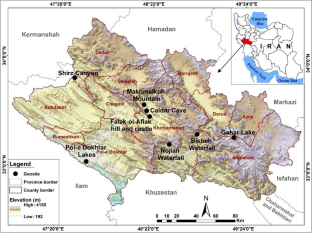
This study is an initial attempt to introduce the concept of geoheritage resilience, which refers to the capacity of a geosite and its system to absorb, adapt, or resist disturbances, and to consider it in geoconservation planning. Assessing the resilience of geoheritage sites is crucial for managing, protecting and developing sustainable geotourism that requires a specific approach and methodology. Therefore, this research aims to propose a comprehensive method based on criteria and indicators to measure the resilience of geoheritage sites and implement it in the most significant geosites of Lorestan province through literature review and fieldwork. The proposed method is based on 5 criteria and 22 indicators. Each indicator is measured based on 5 parameters and calculations are performed using the corresponding equations. The results of the geoheritage resilience assessment, using the proposed method, indicate that various geological, hydroclimatic, ecological, anthropogenic, and geotourism disturbances have led to a reduction the resilience of the geosites studied. According to the results, Calder Cave and Shirz Canyon geosites have a high level of resilience with final scores of 65.62 and 62.62, respectively. In contrast, Bisheh Waterfall and Pol-e Dokhtar Lakes have a low level of resilience with scores of 46.73 and 35.51, respectively. These two geosites are affected by natural and human disturbances, which require effective management, protection, and improvement of their resilience levels. This study has also provided a basic conceptual model to illustrate the planning process for enhancing and promoting geoheritage resilience through geoconservation planning. Given the importance of geoheritage and the potential threats, it is very important to pay attention to the concept of resilience and the measurement of geoheritage resilience in geoconservation planning for sustainable scientific, educational and geotourism use.
期刊介绍:
The Geoheritage journal is an international journal dedicated to discussing all aspects of our global geoheritage, both in situ and portable. The journal will invite all contributions on the conservation of sites and materials - use, protection and practical heritage management - as well as its interpretation through education, training and tourism.
The journal wishes to cover all aspects of geoheritage and its protection. Key topics are:
- Identification, characterisation, quantification and management of geoheritage;
- Geodiversity and geosites;
- On-site science, geological and geomorphological research:
- Global scientific heritage - key scientific geosites, GSSPs, stratotype conservation
and management;
- Scientific research and education, and the promotion of the geosciences thereby;
- Conventions, statute and legal instruments, national and international;
- Integration of biodiversity and geodiversity in nature conservation and land-use
policies;
- Geological heritage and Environmental Impact Assessment studies;
- Geological heritage, sustainable development, community action, practical initiatives and tourism;
- Geoparks: creation, management and outputs;
- Conservation in the natural world, Man-made and natural impacts, climate change;
- Geotourism definitions, methodologies, and case studies;
- International mechanisms for conservation and popularisation - World Heritage Sites,
National Parks etc.;
- Materials, data and people important in the history of science, museums, collections
and all portable geoheritage;
- Education and training of geoheritage specialists;
- Pedagogical use of geological heritage - publications, teaching media, trails, centres,
on-site museums;
- Linking the United Nations Decade of Education for Sustainable Development (2005- 2014) with geoconservation.
 求助内容:
求助内容: 应助结果提醒方式:


