{"title":"梅格纳河口保留区的海岸线动态及其对陆地景观和社会经济状况的影响:孟加拉国尼珠姆德维普的案例研究","authors":"Piash Chowdhury, Md. Bahuddin Sikder","doi":"10.1007/s11852-023-01000-7","DOIUrl":null,"url":null,"abstract":"<p>The southern region of Bangladesh is more unstable than the other part of the country due to massive discharge of heavy sediment through the Meghna estuary. Discussions regarding shoreline representation are critical to regulate the dynamic nature of the coast. This study focuses on measuring the shoreline change, evaluating the LULC (land use & land cover) due to shoreline dynamics utilising multi-dated (1978–2018) satellite images, and changes in the social-economic condition by a direct interview-based questionnaire survey of Nijhum Dwip, Hatiya, Noakhali, Bangladesh. This study assessed shoreline transition through shoreline movement (NSM), endpoint rate (EPR), and prediction based on the EPR rate. 104% of the shore area was increased by -17 m to 86 m annually. Most of the accretion emerged on the Northern and Western sides; erosion only transpired on the Southern side. The shoreline was also projected to increase by 2.2 km, with 644.32 hectares in the study area by 2028. LULC mainly changed due to erosion-accretion activities in the study area. In accreted land, barren land, mudflats, homestead vegetation, and grassland were increased by 15.51 ha, 17.19 ha, 689.68 ha, and 578.17 ha, respectively, where the succession process formed the grassy beach. In contrast, cropland, green, and mangrove vegetation decreased by 12%, 9%, and 0.11%, drastically in its total area, although they had increased in accreted land. It was appraised that the vegetated area will raise 5103.39 hectares by 2028. Thus it was also determined that shoreline change positively impacted migration, economic activities, and tourism. As newly accreted land was cheap or could stay through \"Bndobostho.\" People joined various working fields created in newly accreted land, as farmers increased by 7%. Moreover, about 83% of tourists increased due to shoreline expansion. Finally, this paper intends to contribute several suggestions to the socio-economic development of native people and future strategic management of the reserved coastal area.</p>","PeriodicalId":48909,"journal":{"name":"Journal of Coastal Conservation","volume":"28 1","pages":""},"PeriodicalIF":1.9000,"publicationDate":"2023-12-18","publicationTypes":"Journal Article","fieldsOfStudy":null,"isOpenAccess":false,"openAccessPdf":"","citationCount":"0","resultStr":"{\"title\":\"Shoreline dynamics in the reserved region of meghna estuary and its impact on lulc and socio-economic conditions: a case study from nijhum dwip, Bangladesh\",\"authors\":\"Piash Chowdhury, Md. Bahuddin Sikder\",\"doi\":\"10.1007/s11852-023-01000-7\",\"DOIUrl\":null,\"url\":null,\"abstract\":\"<p>The southern region of Bangladesh is more unstable than the other part of the country due to massive discharge of heavy sediment through the Meghna estuary. Discussions regarding shoreline representation are critical to regulate the dynamic nature of the coast. This study focuses on measuring the shoreline change, evaluating the LULC (land use & land cover) due to shoreline dynamics utilising multi-dated (1978–2018) satellite images, and changes in the social-economic condition by a direct interview-based questionnaire survey of Nijhum Dwip, Hatiya, Noakhali, Bangladesh. This study assessed shoreline transition through shoreline movement (NSM), endpoint rate (EPR), and prediction based on the EPR rate. 104% of the shore area was increased by -17 m to 86 m annually. Most of the accretion emerged on the Northern and Western sides; erosion only transpired on the Southern side. The shoreline was also projected to increase by 2.2 km, with 644.32 hectares in the study area by 2028. LULC mainly changed due to erosion-accretion activities in the study area. In accreted land, barren land, mudflats, homestead vegetation, and grassland were increased by 15.51 ha, 17.19 ha, 689.68 ha, and 578.17 ha, respectively, where the succession process formed the grassy beach. In contrast, cropland, green, and mangrove vegetation decreased by 12%, 9%, and 0.11%, drastically in its total area, although they had increased in accreted land. It was appraised that the vegetated area will raise 5103.39 hectares by 2028. Thus it was also determined that shoreline change positively impacted migration, economic activities, and tourism. As newly accreted land was cheap or could stay through \\\"Bndobostho.\\\" People joined various working fields created in newly accreted land, as farmers increased by 7%. Moreover, about 83% of tourists increased due to shoreline expansion. Finally, this paper intends to contribute several suggestions to the socio-economic development of native people and future strategic management of the reserved coastal area.</p>\",\"PeriodicalId\":48909,\"journal\":{\"name\":\"Journal of Coastal Conservation\",\"volume\":\"28 1\",\"pages\":\"\"},\"PeriodicalIF\":1.9000,\"publicationDate\":\"2023-12-18\",\"publicationTypes\":\"Journal Article\",\"fieldsOfStudy\":null,\"isOpenAccess\":false,\"openAccessPdf\":\"\",\"citationCount\":\"0\",\"resultStr\":null,\"platform\":\"Semanticscholar\",\"paperid\":null,\"PeriodicalName\":\"Journal of Coastal Conservation\",\"FirstCategoryId\":\"93\",\"ListUrlMain\":\"https://doi.org/10.1007/s11852-023-01000-7\",\"RegionNum\":4,\"RegionCategory\":\"环境科学与生态学\",\"ArticlePicture\":[],\"TitleCN\":null,\"AbstractTextCN\":null,\"PMCID\":null,\"EPubDate\":\"\",\"PubModel\":\"\",\"JCR\":\"Q4\",\"JCRName\":\"ENVIRONMENTAL SCIENCES\",\"Score\":null,\"Total\":0}","platform":"Semanticscholar","paperid":null,"PeriodicalName":"Journal of Coastal Conservation","FirstCategoryId":"93","ListUrlMain":"https://doi.org/10.1007/s11852-023-01000-7","RegionNum":4,"RegionCategory":"环境科学与生态学","ArticlePicture":[],"TitleCN":null,"AbstractTextCN":null,"PMCID":null,"EPubDate":"","PubModel":"","JCR":"Q4","JCRName":"ENVIRONMENTAL SCIENCES","Score":null,"Total":0}
Shoreline dynamics in the reserved region of meghna estuary and its impact on lulc and socio-economic conditions: a case study from nijhum dwip, Bangladesh
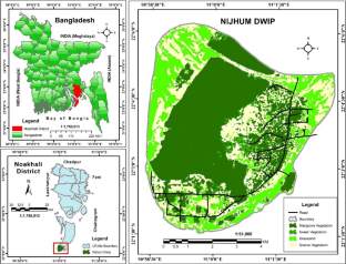
The southern region of Bangladesh is more unstable than the other part of the country due to massive discharge of heavy sediment through the Meghna estuary. Discussions regarding shoreline representation are critical to regulate the dynamic nature of the coast. This study focuses on measuring the shoreline change, evaluating the LULC (land use & land cover) due to shoreline dynamics utilising multi-dated (1978–2018) satellite images, and changes in the social-economic condition by a direct interview-based questionnaire survey of Nijhum Dwip, Hatiya, Noakhali, Bangladesh. This study assessed shoreline transition through shoreline movement (NSM), endpoint rate (EPR), and prediction based on the EPR rate. 104% of the shore area was increased by -17 m to 86 m annually. Most of the accretion emerged on the Northern and Western sides; erosion only transpired on the Southern side. The shoreline was also projected to increase by 2.2 km, with 644.32 hectares in the study area by 2028. LULC mainly changed due to erosion-accretion activities in the study area. In accreted land, barren land, mudflats, homestead vegetation, and grassland were increased by 15.51 ha, 17.19 ha, 689.68 ha, and 578.17 ha, respectively, where the succession process formed the grassy beach. In contrast, cropland, green, and mangrove vegetation decreased by 12%, 9%, and 0.11%, drastically in its total area, although they had increased in accreted land. It was appraised that the vegetated area will raise 5103.39 hectares by 2028. Thus it was also determined that shoreline change positively impacted migration, economic activities, and tourism. As newly accreted land was cheap or could stay through "Bndobostho." People joined various working fields created in newly accreted land, as farmers increased by 7%. Moreover, about 83% of tourists increased due to shoreline expansion. Finally, this paper intends to contribute several suggestions to the socio-economic development of native people and future strategic management of the reserved coastal area.
期刊介绍:
The Journal of Coastal Conservation is a scientific journal for the dissemination of both theoretical and applied research on integrated and sustainable management of the terrestrial, coastal and marine environmental interface.
A thorough understanding of both the physical and the human sciences is important to the study of the spatial patterns and processes observed in terrestrial, coastal and marine systems set in the context of past, present and future social and economic developments. This includes multidisciplinary and integrated knowledge and understanding of: physical geography, coastal geomorphology, sediment dynamics, hydrodynamics, soil science, hydrology, plant and animal ecology, vegetation science, biogeography, landscape ecology, recreation and tourism studies, urban and human ecology, coastal engineering and spatial planning, coastal zone management, and marine resource management.
 求助内容:
求助内容: 应助结果提醒方式:


