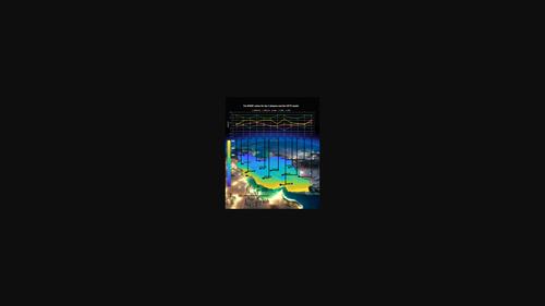
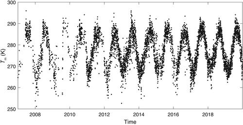
{"title":"数据源对计算伊朗平均气温和综合水汽的影响","authors":"Hassan Rahimi, Jamal Asgari, Vahab Nafisi","doi":"10.1002/met.2167","DOIUrl":null,"url":null,"abstract":"<p>The weighted mean temperature (<math>\n <mrow>\n <msub>\n <mi>T</mi>\n <mi>m</mi>\n </msub>\n </mrow></math>) plays a crucial role in calculating Precipitable Water Vapor (PWV) and integrated water vapor (IWV) using Global Navigation Satellite Systems (GNSS) techniques. Currently, the primary sources for meteorological parameters are radiosonde measurements and Numerical Weather Models (NWMs). This study focuses on assessing the influence of different data sources on the computation of <math>\n <mrow>\n <msub>\n <mi>T</mi>\n <mi>m</mi>\n </msub>\n </mrow></math> and IWV in Iran. The investigation involved comparing several datasets: ERA5 numerical data with spatial resolutions of 0.125° and 2.5° (ERA5 0.125, ERA5 2.5), ERA-Interim, NCEP numerical data and <math>\n <mrow>\n <msub>\n <mi>T</mi>\n <mi>m</mi>\n </msub>\n </mrow></math> results derived from the GPT3 model. Validation of the results utilized data from 12 radiosonde stations situated across Iran. In addition, the precision of the IWV parameter was evaluated by utilizing measurements from the only available IGS station in the region, situated in Tehran. The results revealed that ERA5 0.125 exhibited superior accuracy in <math>\n <mrow>\n <msub>\n <mi>T</mi>\n <mi>m</mi>\n </msub>\n </mrow></math> estimation compared with the other datasets, showing a discrepancy of approximately 1–2 K. In contrast, the GPT3 model displayed an accuracy of about 3 K. Analysing the results across different months of the year revealed elevated root mean square error (RMSE) values during warmer months, with little variability based on station height in the region for the four datasets. Regarding IWV, the ERA5 0.125 dataset outperformed the other three datasets, demonstrating an accuracy of about 0.07 kg m<sup>−2</sup>. Notably, RMSE values during summer were approximately 50% higher compared with the annual RMSE.</p>","PeriodicalId":49825,"journal":{"name":"Meteorological Applications","volume":"30 6","pages":""},"PeriodicalIF":2.3000,"publicationDate":"2023-12-13","publicationTypes":"Journal Article","fieldsOfStudy":null,"isOpenAccess":false,"openAccessPdf":"https://rmets.onlinelibrary.wiley.com/doi/epdf/10.1002/met.2167","citationCount":"0","resultStr":"{\"title\":\"The effect of data sources on calculating mean temperature and integrated water vapor in Iran\",\"authors\":\"Hassan Rahimi, Jamal Asgari, Vahab Nafisi\",\"doi\":\"10.1002/met.2167\",\"DOIUrl\":null,\"url\":null,\"abstract\":\"<p>The weighted mean temperature (<math>\\n <mrow>\\n <msub>\\n <mi>T</mi>\\n <mi>m</mi>\\n </msub>\\n </mrow></math>) plays a crucial role in calculating Precipitable Water Vapor (PWV) and integrated water vapor (IWV) using Global Navigation Satellite Systems (GNSS) techniques. Currently, the primary sources for meteorological parameters are radiosonde measurements and Numerical Weather Models (NWMs). This study focuses on assessing the influence of different data sources on the computation of <math>\\n <mrow>\\n <msub>\\n <mi>T</mi>\\n <mi>m</mi>\\n </msub>\\n </mrow></math> and IWV in Iran. The investigation involved comparing several datasets: ERA5 numerical data with spatial resolutions of 0.125° and 2.5° (ERA5 0.125, ERA5 2.5), ERA-Interim, NCEP numerical data and <math>\\n <mrow>\\n <msub>\\n <mi>T</mi>\\n <mi>m</mi>\\n </msub>\\n </mrow></math> results derived from the GPT3 model. Validation of the results utilized data from 12 radiosonde stations situated across Iran. In addition, the precision of the IWV parameter was evaluated by utilizing measurements from the only available IGS station in the region, situated in Tehran. The results revealed that ERA5 0.125 exhibited superior accuracy in <math>\\n <mrow>\\n <msub>\\n <mi>T</mi>\\n <mi>m</mi>\\n </msub>\\n </mrow></math> estimation compared with the other datasets, showing a discrepancy of approximately 1–2 K. In contrast, the GPT3 model displayed an accuracy of about 3 K. Analysing the results across different months of the year revealed elevated root mean square error (RMSE) values during warmer months, with little variability based on station height in the region for the four datasets. Regarding IWV, the ERA5 0.125 dataset outperformed the other three datasets, demonstrating an accuracy of about 0.07 kg m<sup>−2</sup>. Notably, RMSE values during summer were approximately 50% higher compared with the annual RMSE.</p>\",\"PeriodicalId\":49825,\"journal\":{\"name\":\"Meteorological Applications\",\"volume\":\"30 6\",\"pages\":\"\"},\"PeriodicalIF\":2.3000,\"publicationDate\":\"2023-12-13\",\"publicationTypes\":\"Journal Article\",\"fieldsOfStudy\":null,\"isOpenAccess\":false,\"openAccessPdf\":\"https://rmets.onlinelibrary.wiley.com/doi/epdf/10.1002/met.2167\",\"citationCount\":\"0\",\"resultStr\":null,\"platform\":\"Semanticscholar\",\"paperid\":null,\"PeriodicalName\":\"Meteorological Applications\",\"FirstCategoryId\":\"89\",\"ListUrlMain\":\"https://onlinelibrary.wiley.com/doi/10.1002/met.2167\",\"RegionNum\":4,\"RegionCategory\":\"地球科学\",\"ArticlePicture\":[],\"TitleCN\":null,\"AbstractTextCN\":null,\"PMCID\":null,\"EPubDate\":\"\",\"PubModel\":\"\",\"JCR\":\"Q3\",\"JCRName\":\"METEOROLOGY & ATMOSPHERIC SCIENCES\",\"Score\":null,\"Total\":0}","platform":"Semanticscholar","paperid":null,"PeriodicalName":"Meteorological Applications","FirstCategoryId":"89","ListUrlMain":"https://onlinelibrary.wiley.com/doi/10.1002/met.2167","RegionNum":4,"RegionCategory":"地球科学","ArticlePicture":[],"TitleCN":null,"AbstractTextCN":null,"PMCID":null,"EPubDate":"","PubModel":"","JCR":"Q3","JCRName":"METEOROLOGY & ATMOSPHERIC SCIENCES","Score":null,"Total":0}
引用次数: 0
摘要
加权平均温度(Tm)在全球导航卫星系统(GNSS)计算可降水量(PWV)和综合水汽(IWV)中起着至关重要的作用。目前,气象参数的主要来源是探空测量和数值天气模式(NWMs)。本研究侧重于评估不同数据源对伊朗Tm和IWV计算的影响。研究比较了空间分辨率为0.125°和2.5°的ERA5数值数据(ERA5 0.125, ERA5 2.5)、ERA-Interim、NCEP数值数据和GPT3模型的Tm结果。结果的验证利用了位于伊朗各地的12个无线电探空站的数据。此外,利用位于德黑兰的该地区唯一可用的IGS站的测量结果,对IWV参数的精度进行了评估。结果表明,与其他数据集相比,ERA5 0.125在Tm估计中表现出更高的精度,差异约为1-2 K。相比之下,GPT3模型显示的精度约为3k。分析一年中不同月份的结果显示,在温暖的月份,均方根误差(RMSE)值升高,四个数据集在该地区基于站高的变化很小。在IWV方面,ERA5 0.125数据集优于其他三个数据集,其精度约为0.07 kg m−2。值得注意的是,夏季的RMSE值比全年RMSE高约50%。
The effect of data sources on calculating mean temperature and integrated water vapor in Iran
The weighted mean temperature () plays a crucial role in calculating Precipitable Water Vapor (PWV) and integrated water vapor (IWV) using Global Navigation Satellite Systems (GNSS) techniques. Currently, the primary sources for meteorological parameters are radiosonde measurements and Numerical Weather Models (NWMs). This study focuses on assessing the influence of different data sources on the computation of and IWV in Iran. The investigation involved comparing several datasets: ERA5 numerical data with spatial resolutions of 0.125° and 2.5° (ERA5 0.125, ERA5 2.5), ERA-Interim, NCEP numerical data and results derived from the GPT3 model. Validation of the results utilized data from 12 radiosonde stations situated across Iran. In addition, the precision of the IWV parameter was evaluated by utilizing measurements from the only available IGS station in the region, situated in Tehran. The results revealed that ERA5 0.125 exhibited superior accuracy in estimation compared with the other datasets, showing a discrepancy of approximately 1–2 K. In contrast, the GPT3 model displayed an accuracy of about 3 K. Analysing the results across different months of the year revealed elevated root mean square error (RMSE) values during warmer months, with little variability based on station height in the region for the four datasets. Regarding IWV, the ERA5 0.125 dataset outperformed the other three datasets, demonstrating an accuracy of about 0.07 kg m−2. Notably, RMSE values during summer were approximately 50% higher compared with the annual RMSE.
期刊介绍:
The aim of Meteorological Applications is to serve the needs of applied meteorologists, forecasters and users of meteorological services by publishing papers on all aspects of meteorological science, including:
applications of meteorological, climatological, analytical and forecasting data, and their socio-economic benefits;
forecasting, warning and service delivery techniques and methods;
weather hazards, their analysis and prediction;
performance, verification and value of numerical models and forecasting services;
practical applications of ocean and climate models;
education and training.
 求助内容:
求助内容: 应助结果提醒方式:


