{"title":"基于云对地观测数据的林波波河跨界河流流域湿地长期大尺度变化动态评估","authors":"Siyamthanda Gxokwe, Timothy Dube, Dominic Mazvimavi","doi":"10.1007/s11273-023-09963-y","DOIUrl":null,"url":null,"abstract":"<p>Significant progress has been made in monitoring and assessing the effects of land use and land cover (LULC) changes on wetland extent. However, our understanding of wetland within the transboundary basins has been limited by the scarcity of available data on their dynamic changes over time. This study aimed to address this gap by analyzing the long-term and large-scale spatio-temporal extent of wetland in the Limpopo transboundary river basin (LTRB) over a 20-year period (2000–2020). To achieve this, we utilized the Google Earth Engine (GEE) cloud-computing platform and various remotely sensed data. The study had two primary objectives; (1) to examine LULC changes over time using machine learning algorithms applied to multisource remotely sensed data in GEE, and (2) to assess the relationship between LULC changes and the extent of wetlands in the basin. A total of nine land cover classes were identified, including shrublands, croplands, bare-surface, wetlands, sparse vegetation, tree cover, built-up areas, and grasslands. Shrublands covered 76–82% of the LTRB. On the other hand, wetlands and sparse vegetation were the least dominant, with proportions ranging from 0.3 to 2%. The overall accuracy of the classification results was within acceptable ranges, ranging from 77 to 78%. The study further revealed a continuing decline in wetlands extent and sparse vegetation, with average rates of 19% and 44%, respectively. Conversely, shrublands, croplands, and tree cover showed an increase, with average rates of 0.4% and 12.4% respectively. A significant finding was the replacement of a substantial portion (40%) of wetland areas with built-up areas, indicating that urban expansion is a major driver of wetland shrinkage in the study area. These results provide valuable insights into the declining extent of wetlands in the LTRB. Such findings are crucial for environmental management efforts, as they provide information on which wetlands should be prioritized when implementing strategies to prevent the negative impacts of LULC changes on wetlands in the area. Therefore, contributing towards achieving sustainable development goals relating to freshwater ecosystems protection and management.</p>","PeriodicalId":49363,"journal":{"name":"Wetlands Ecology and Management","volume":"4 1","pages":""},"PeriodicalIF":1.6000,"publicationDate":"2023-11-30","publicationTypes":"Journal Article","fieldsOfStudy":null,"isOpenAccess":false,"openAccessPdf":"","citationCount":"0","resultStr":"{\"title\":\"An assessment of long-term and large-scale wetlands change dynamics in the Limpopo transboundary river basin using cloud-based Earth observation data\",\"authors\":\"Siyamthanda Gxokwe, Timothy Dube, Dominic Mazvimavi\",\"doi\":\"10.1007/s11273-023-09963-y\",\"DOIUrl\":null,\"url\":null,\"abstract\":\"<p>Significant progress has been made in monitoring and assessing the effects of land use and land cover (LULC) changes on wetland extent. However, our understanding of wetland within the transboundary basins has been limited by the scarcity of available data on their dynamic changes over time. This study aimed to address this gap by analyzing the long-term and large-scale spatio-temporal extent of wetland in the Limpopo transboundary river basin (LTRB) over a 20-year period (2000–2020). To achieve this, we utilized the Google Earth Engine (GEE) cloud-computing platform and various remotely sensed data. The study had two primary objectives; (1) to examine LULC changes over time using machine learning algorithms applied to multisource remotely sensed data in GEE, and (2) to assess the relationship between LULC changes and the extent of wetlands in the basin. A total of nine land cover classes were identified, including shrublands, croplands, bare-surface, wetlands, sparse vegetation, tree cover, built-up areas, and grasslands. Shrublands covered 76–82% of the LTRB. On the other hand, wetlands and sparse vegetation were the least dominant, with proportions ranging from 0.3 to 2%. The overall accuracy of the classification results was within acceptable ranges, ranging from 77 to 78%. The study further revealed a continuing decline in wetlands extent and sparse vegetation, with average rates of 19% and 44%, respectively. Conversely, shrublands, croplands, and tree cover showed an increase, with average rates of 0.4% and 12.4% respectively. A significant finding was the replacement of a substantial portion (40%) of wetland areas with built-up areas, indicating that urban expansion is a major driver of wetland shrinkage in the study area. These results provide valuable insights into the declining extent of wetlands in the LTRB. Such findings are crucial for environmental management efforts, as they provide information on which wetlands should be prioritized when implementing strategies to prevent the negative impacts of LULC changes on wetlands in the area. Therefore, contributing towards achieving sustainable development goals relating to freshwater ecosystems protection and management.</p>\",\"PeriodicalId\":49363,\"journal\":{\"name\":\"Wetlands Ecology and Management\",\"volume\":\"4 1\",\"pages\":\"\"},\"PeriodicalIF\":1.6000,\"publicationDate\":\"2023-11-30\",\"publicationTypes\":\"Journal Article\",\"fieldsOfStudy\":null,\"isOpenAccess\":false,\"openAccessPdf\":\"\",\"citationCount\":\"0\",\"resultStr\":null,\"platform\":\"Semanticscholar\",\"paperid\":null,\"PeriodicalName\":\"Wetlands Ecology and Management\",\"FirstCategoryId\":\"93\",\"ListUrlMain\":\"https://doi.org/10.1007/s11273-023-09963-y\",\"RegionNum\":4,\"RegionCategory\":\"环境科学与生态学\",\"ArticlePicture\":[],\"TitleCN\":null,\"AbstractTextCN\":null,\"PMCID\":null,\"EPubDate\":\"\",\"PubModel\":\"\",\"JCR\":\"Q4\",\"JCRName\":\"ENVIRONMENTAL SCIENCES\",\"Score\":null,\"Total\":0}","platform":"Semanticscholar","paperid":null,"PeriodicalName":"Wetlands Ecology and Management","FirstCategoryId":"93","ListUrlMain":"https://doi.org/10.1007/s11273-023-09963-y","RegionNum":4,"RegionCategory":"环境科学与生态学","ArticlePicture":[],"TitleCN":null,"AbstractTextCN":null,"PMCID":null,"EPubDate":"","PubModel":"","JCR":"Q4","JCRName":"ENVIRONMENTAL SCIENCES","Score":null,"Total":0}
An assessment of long-term and large-scale wetlands change dynamics in the Limpopo transboundary river basin using cloud-based Earth observation data
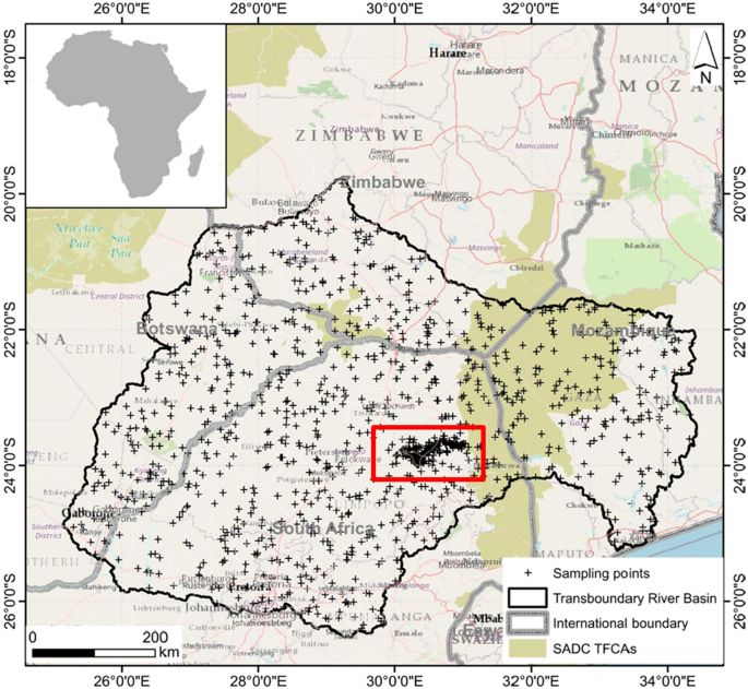
Significant progress has been made in monitoring and assessing the effects of land use and land cover (LULC) changes on wetland extent. However, our understanding of wetland within the transboundary basins has been limited by the scarcity of available data on their dynamic changes over time. This study aimed to address this gap by analyzing the long-term and large-scale spatio-temporal extent of wetland in the Limpopo transboundary river basin (LTRB) over a 20-year period (2000–2020). To achieve this, we utilized the Google Earth Engine (GEE) cloud-computing platform and various remotely sensed data. The study had two primary objectives; (1) to examine LULC changes over time using machine learning algorithms applied to multisource remotely sensed data in GEE, and (2) to assess the relationship between LULC changes and the extent of wetlands in the basin. A total of nine land cover classes were identified, including shrublands, croplands, bare-surface, wetlands, sparse vegetation, tree cover, built-up areas, and grasslands. Shrublands covered 76–82% of the LTRB. On the other hand, wetlands and sparse vegetation were the least dominant, with proportions ranging from 0.3 to 2%. The overall accuracy of the classification results was within acceptable ranges, ranging from 77 to 78%. The study further revealed a continuing decline in wetlands extent and sparse vegetation, with average rates of 19% and 44%, respectively. Conversely, shrublands, croplands, and tree cover showed an increase, with average rates of 0.4% and 12.4% respectively. A significant finding was the replacement of a substantial portion (40%) of wetland areas with built-up areas, indicating that urban expansion is a major driver of wetland shrinkage in the study area. These results provide valuable insights into the declining extent of wetlands in the LTRB. Such findings are crucial for environmental management efforts, as they provide information on which wetlands should be prioritized when implementing strategies to prevent the negative impacts of LULC changes on wetlands in the area. Therefore, contributing towards achieving sustainable development goals relating to freshwater ecosystems protection and management.
期刊介绍:
Wetlands Ecology and Management is an international journal that publishes authoritative and original articles on topics relevant to freshwater, brackish and marine coastal wetland ecosystems. The Journal serves as a multi-disciplinary forum covering key issues in wetlands science, management, policy and economics. As such, Wetlands Ecology and Management aims to encourage the exchange of information between environmental managers, pure and applied scientists, and national and international authorities on wetlands policy and ecological economics.
 求助内容:
求助内容: 应助结果提醒方式:


