I. N. Vladimirov, V. B. Vyrkin, D. V. Kobylkin, A. P. Sofronov
{"title":"阿穆特洼地(西贝加里亚东北部)地貌与景观","authors":"I. N. Vladimirov, V. B. Vyrkin, D. V. Kobylkin, A. P. Sofronov","doi":"10.1134/s187537282203012x","DOIUrl":null,"url":null,"abstract":"<h3 data-test=\"abstract-sub-heading\">Abstract</h3><p>A generalized description of a modern geomorphologic structure—the landscapes of the Amut Depression as one of the elements of the rift system of northeastern Cisbaikalia—is given for the first time. The main features in the relief formation of the depression are outlined and the principal factors are determined. This study has revealed the predomination of fluvial, lacustrine, and cryogenic processes in the modern morphogenesis of the depression. Special attention is paid to the study of lakes. Modern methods of bathymetric surveys are used to determine the main parameters of the basins of the major lakes in the depression: Amut, Malan-Zurkhen, Balan-Tamur, and Churikto. It has been revealed that ancient glaciers and tectonic movements were involved in the formation and configuration of the lake basins. The current shape of the shore zone depends on the geological structure, in which a special role is played by thermoabrasion and thermodenudation. Since the study area is assigned to the Dzherginskii State Nature Reserve with its principal mission to preserve natural systems, landscape investigations have been performed. The medium-scale map of the depression and surrounding mountains is based on the concept of geosystems by Academician V.B. Sochava and compiled with the use of classical methods of studying the plant cover complemented by images taken by an unmanned flying vehicle and data from remote sensing of the Earth. The salient features of the modern status of landscapes in the study area are highlighted. The main role in the structure of the landscapes is played by mountain–taiga and mountain–depression larch geosystems with mature moss–lichen cover. At higher hypsometric levels, a greater area is occupied by subshrub–lichen sparse larch communities.</p>","PeriodicalId":44739,"journal":{"name":"Geography and Natural Resources","volume":"3 1","pages":""},"PeriodicalIF":0.3000,"publicationDate":"2022-12-08","publicationTypes":"Journal Article","fieldsOfStudy":null,"isOpenAccess":false,"openAccessPdf":"","citationCount":"0","resultStr":"{\"title\":\"Relief and Landscapes of the Amut Depression (Northeastern Cisbaikalia)\",\"authors\":\"I. N. Vladimirov, V. B. Vyrkin, D. V. Kobylkin, A. P. Sofronov\",\"doi\":\"10.1134/s187537282203012x\",\"DOIUrl\":null,\"url\":null,\"abstract\":\"<h3 data-test=\\\"abstract-sub-heading\\\">Abstract</h3><p>A generalized description of a modern geomorphologic structure—the landscapes of the Amut Depression as one of the elements of the rift system of northeastern Cisbaikalia—is given for the first time. The main features in the relief formation of the depression are outlined and the principal factors are determined. This study has revealed the predomination of fluvial, lacustrine, and cryogenic processes in the modern morphogenesis of the depression. Special attention is paid to the study of lakes. Modern methods of bathymetric surveys are used to determine the main parameters of the basins of the major lakes in the depression: Amut, Malan-Zurkhen, Balan-Tamur, and Churikto. It has been revealed that ancient glaciers and tectonic movements were involved in the formation and configuration of the lake basins. The current shape of the shore zone depends on the geological structure, in which a special role is played by thermoabrasion and thermodenudation. Since the study area is assigned to the Dzherginskii State Nature Reserve with its principal mission to preserve natural systems, landscape investigations have been performed. The medium-scale map of the depression and surrounding mountains is based on the concept of geosystems by Academician V.B. Sochava and compiled with the use of classical methods of studying the plant cover complemented by images taken by an unmanned flying vehicle and data from remote sensing of the Earth. The salient features of the modern status of landscapes in the study area are highlighted. The main role in the structure of the landscapes is played by mountain–taiga and mountain–depression larch geosystems with mature moss–lichen cover. At higher hypsometric levels, a greater area is occupied by subshrub–lichen sparse larch communities.</p>\",\"PeriodicalId\":44739,\"journal\":{\"name\":\"Geography and Natural Resources\",\"volume\":\"3 1\",\"pages\":\"\"},\"PeriodicalIF\":0.3000,\"publicationDate\":\"2022-12-08\",\"publicationTypes\":\"Journal Article\",\"fieldsOfStudy\":null,\"isOpenAccess\":false,\"openAccessPdf\":\"\",\"citationCount\":\"0\",\"resultStr\":null,\"platform\":\"Semanticscholar\",\"paperid\":null,\"PeriodicalName\":\"Geography and Natural Resources\",\"FirstCategoryId\":\"1085\",\"ListUrlMain\":\"https://doi.org/10.1134/s187537282203012x\",\"RegionNum\":0,\"RegionCategory\":null,\"ArticlePicture\":[],\"TitleCN\":null,\"AbstractTextCN\":null,\"PMCID\":null,\"EPubDate\":\"\",\"PubModel\":\"\",\"JCR\":\"Q4\",\"JCRName\":\"GEOGRAPHY\",\"Score\":null,\"Total\":0}","platform":"Semanticscholar","paperid":null,"PeriodicalName":"Geography and Natural Resources","FirstCategoryId":"1085","ListUrlMain":"https://doi.org/10.1134/s187537282203012x","RegionNum":0,"RegionCategory":null,"ArticlePicture":[],"TitleCN":null,"AbstractTextCN":null,"PMCID":null,"EPubDate":"","PubModel":"","JCR":"Q4","JCRName":"GEOGRAPHY","Score":null,"Total":0}
Relief and Landscapes of the Amut Depression (Northeastern Cisbaikalia)
Abstract
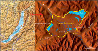
A generalized description of a modern geomorphologic structure—the landscapes of the Amut Depression as one of the elements of the rift system of northeastern Cisbaikalia—is given for the first time. The main features in the relief formation of the depression are outlined and the principal factors are determined. This study has revealed the predomination of fluvial, lacustrine, and cryogenic processes in the modern morphogenesis of the depression. Special attention is paid to the study of lakes. Modern methods of bathymetric surveys are used to determine the main parameters of the basins of the major lakes in the depression: Amut, Malan-Zurkhen, Balan-Tamur, and Churikto. It has been revealed that ancient glaciers and tectonic movements were involved in the formation and configuration of the lake basins. The current shape of the shore zone depends on the geological structure, in which a special role is played by thermoabrasion and thermodenudation. Since the study area is assigned to the Dzherginskii State Nature Reserve with its principal mission to preserve natural systems, landscape investigations have been performed. The medium-scale map of the depression and surrounding mountains is based on the concept of geosystems by Academician V.B. Sochava and compiled with the use of classical methods of studying the plant cover complemented by images taken by an unmanned flying vehicle and data from remote sensing of the Earth. The salient features of the modern status of landscapes in the study area are highlighted. The main role in the structure of the landscapes is played by mountain–taiga and mountain–depression larch geosystems with mature moss–lichen cover. At higher hypsometric levels, a greater area is occupied by subshrub–lichen sparse larch communities.
期刊介绍:
Geography and Natural Resources publishes information on research results in the field of geographical studies of nature, the economy, and the population. It provides ample coverage of the geographical aspects related to solving major economic problems, with special emphasis on regional nature management and environmental protection, geographical forecasting, integral regional research developments, modelling of natural processes, and on the advancement of mapping techniques. The journal publishes contributions on monitoring studies, geographical research abroad, as well as discussions on the theory of science.
 求助内容:
求助内容: 应助结果提醒方式:


