{"title":"西藏东南部现今上地壳应变率场及其地球动力学影响:用 ABIC 方法从 GPS 测量中获得的制约因素","authors":"Shaohua YANG, Jiawei PAN, Haibing LI, Yaolin SHI","doi":"10.1111/1755-6724.15122","DOIUrl":null,"url":null,"abstract":"<p>The Earth's surface kinematics and deformation are fundamental to understanding crustal evolution. An effective research approach is to estimate regional motion field and deformation fields based on modern geodetic networks. If the discrete observed velocity field is obtained, the velocity related fields, such as dilatation rate and maximum shear strain rate, can be estimated by applying varied mathematical approaches. This study applied Akaike's Bayesian Information Criterion (ABIC) method to calculate strain rate fields constrained by GPS observations in the southeast Tibetan Plateau. Comparison with results derived from other three methods revealed that our ABIC-derived strain rate fields were more precise. The maximum shear strain rate highlighted the Xianshuihe–Xiaojiang fault system as the main boundary for the outward migration of material in southeastern Tibet, indicating rotation of eastern Tibet material around the eastern Himalaya rather than whole extrusion along a fixed channel. Additionally, distinct dilatation rate patterns in the northeast and southwest regions of the fault system were observed. The northeast region, represented by the Longmenshan area, exhibited negative dilatational anomalies; while the southwest region, represented by the Jinsha River area north of 29°N, displayed positive dilatational anomalies. This indicates compression in the former and extension in the latter. Combined with deep geophysical observations, we believe that the upper and lower crusts of the Jinsha River area north of 29°N are in an entire expanding state, probably caused by the escape-drag effect of material. The presence of a large, low-viscosity region south of 29°N may not enable the entire escape of the crust, but instead result in a differential escape of the lower crust faster than the upper crust.</p>","PeriodicalId":7095,"journal":{"name":"Acta Geologica Sinica ‐ English Edition","volume":null,"pages":null},"PeriodicalIF":3.5000,"publicationDate":"2023-10-28","publicationTypes":"Journal Article","fieldsOfStudy":null,"isOpenAccess":false,"openAccessPdf":"","citationCount":"0","resultStr":"{\"title\":\"Present-day Upper-crustal Strain Rate Field in Southeastern Tibet and its Geodynamic Implications: Constraints from GPS Measurements with ABIC Method\",\"authors\":\"Shaohua YANG, Jiawei PAN, Haibing LI, Yaolin SHI\",\"doi\":\"10.1111/1755-6724.15122\",\"DOIUrl\":null,\"url\":null,\"abstract\":\"<p>The Earth's surface kinematics and deformation are fundamental to understanding crustal evolution. An effective research approach is to estimate regional motion field and deformation fields based on modern geodetic networks. If the discrete observed velocity field is obtained, the velocity related fields, such as dilatation rate and maximum shear strain rate, can be estimated by applying varied mathematical approaches. This study applied Akaike's Bayesian Information Criterion (ABIC) method to calculate strain rate fields constrained by GPS observations in the southeast Tibetan Plateau. Comparison with results derived from other three methods revealed that our ABIC-derived strain rate fields were more precise. The maximum shear strain rate highlighted the Xianshuihe–Xiaojiang fault system as the main boundary for the outward migration of material in southeastern Tibet, indicating rotation of eastern Tibet material around the eastern Himalaya rather than whole extrusion along a fixed channel. Additionally, distinct dilatation rate patterns in the northeast and southwest regions of the fault system were observed. The northeast region, represented by the Longmenshan area, exhibited negative dilatational anomalies; while the southwest region, represented by the Jinsha River area north of 29°N, displayed positive dilatational anomalies. This indicates compression in the former and extension in the latter. Combined with deep geophysical observations, we believe that the upper and lower crusts of the Jinsha River area north of 29°N are in an entire expanding state, probably caused by the escape-drag effect of material. The presence of a large, low-viscosity region south of 29°N may not enable the entire escape of the crust, but instead result in a differential escape of the lower crust faster than the upper crust.</p>\",\"PeriodicalId\":7095,\"journal\":{\"name\":\"Acta Geologica Sinica ‐ English Edition\",\"volume\":null,\"pages\":null},\"PeriodicalIF\":3.5000,\"publicationDate\":\"2023-10-28\",\"publicationTypes\":\"Journal Article\",\"fieldsOfStudy\":null,\"isOpenAccess\":false,\"openAccessPdf\":\"\",\"citationCount\":\"0\",\"resultStr\":null,\"platform\":\"Semanticscholar\",\"paperid\":null,\"PeriodicalName\":\"Acta Geologica Sinica ‐ English Edition\",\"FirstCategoryId\":\"89\",\"ListUrlMain\":\"https://onlinelibrary.wiley.com/doi/10.1111/1755-6724.15122\",\"RegionNum\":3,\"RegionCategory\":\"地球科学\",\"ArticlePicture\":[],\"TitleCN\":null,\"AbstractTextCN\":null,\"PMCID\":null,\"EPubDate\":\"\",\"PubModel\":\"\",\"JCR\":\"Q1\",\"JCRName\":\"GEOSCIENCES, MULTIDISCIPLINARY\",\"Score\":null,\"Total\":0}","platform":"Semanticscholar","paperid":null,"PeriodicalName":"Acta Geologica Sinica ‐ English Edition","FirstCategoryId":"89","ListUrlMain":"https://onlinelibrary.wiley.com/doi/10.1111/1755-6724.15122","RegionNum":3,"RegionCategory":"地球科学","ArticlePicture":[],"TitleCN":null,"AbstractTextCN":null,"PMCID":null,"EPubDate":"","PubModel":"","JCR":"Q1","JCRName":"GEOSCIENCES, MULTIDISCIPLINARY","Score":null,"Total":0}
Present-day Upper-crustal Strain Rate Field in Southeastern Tibet and its Geodynamic Implications: Constraints from GPS Measurements with ABIC Method
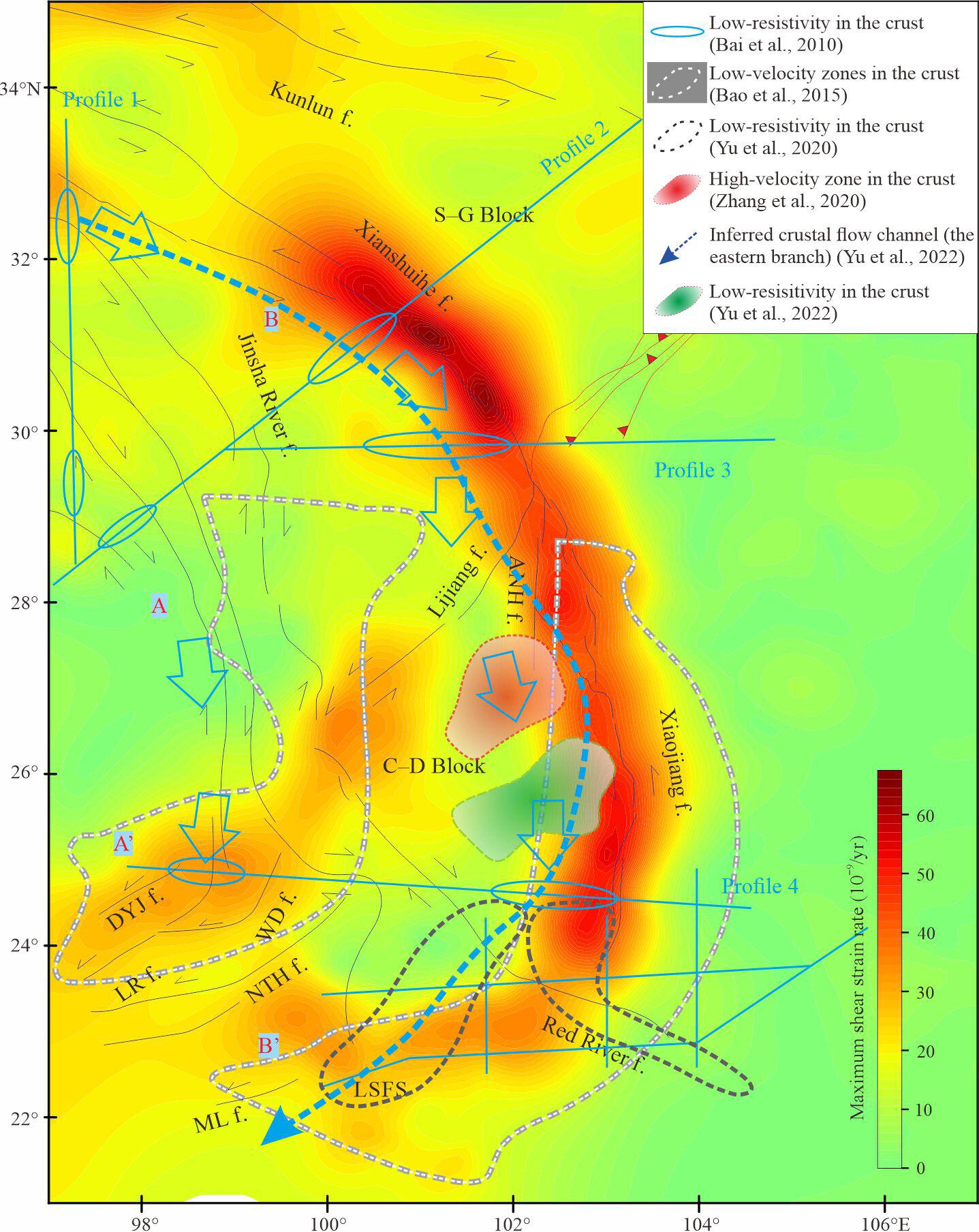
The Earth's surface kinematics and deformation are fundamental to understanding crustal evolution. An effective research approach is to estimate regional motion field and deformation fields based on modern geodetic networks. If the discrete observed velocity field is obtained, the velocity related fields, such as dilatation rate and maximum shear strain rate, can be estimated by applying varied mathematical approaches. This study applied Akaike's Bayesian Information Criterion (ABIC) method to calculate strain rate fields constrained by GPS observations in the southeast Tibetan Plateau. Comparison with results derived from other three methods revealed that our ABIC-derived strain rate fields were more precise. The maximum shear strain rate highlighted the Xianshuihe–Xiaojiang fault system as the main boundary for the outward migration of material in southeastern Tibet, indicating rotation of eastern Tibet material around the eastern Himalaya rather than whole extrusion along a fixed channel. Additionally, distinct dilatation rate patterns in the northeast and southwest regions of the fault system were observed. The northeast region, represented by the Longmenshan area, exhibited negative dilatational anomalies; while the southwest region, represented by the Jinsha River area north of 29°N, displayed positive dilatational anomalies. This indicates compression in the former and extension in the latter. Combined with deep geophysical observations, we believe that the upper and lower crusts of the Jinsha River area north of 29°N are in an entire expanding state, probably caused by the escape-drag effect of material. The presence of a large, low-viscosity region south of 29°N may not enable the entire escape of the crust, but instead result in a differential escape of the lower crust faster than the upper crust.
期刊介绍:
Acta Geologica Sinica mainly reports the latest and most important achievements in the theoretical and basic research in geological sciences, together with new technologies, in China. Papers published involve various aspects of research concerning geosciences and related disciplines, such as stratigraphy, palaeontology, origin and history of the Earth, structural geology, tectonics, mineralogy, petrology, geochemistry, geophysics, geology of mineral deposits, hydrogeology, engineering geology, environmental geology, regional geology and new theories and technologies of geological exploration.
 求助内容:
求助内容: 应助结果提醒方式:


