达加斯加西南部复杂多层水系中的水体混合过程:联合同位素和压力测量方法

IF 2.4 3区 地球科学 Q2 GEOSCIENCES, MULTIDISCIPLINARY
Simon D. Carrière, Pascale F. M. Rakotomandrindra, Thomas Heath, Konstantinos Chalikakis, Marina Gillon, Marc Leblanc, Sarah Tweed
{"title":"达加斯加西南部复杂多层水系中的水体混合过程:联合同位素和压力测量方法","authors":"Simon D. Carrière, Pascale F. M. Rakotomandrindra, Thomas Heath, Konstantinos Chalikakis, Marina Gillon, Marc Leblanc, Sarah Tweed","doi":"10.1007/s10040-023-02731-5","DOIUrl":null,"url":null,"abstract":"Abstract Water transfers through a multilayered aquifer system are difficult to characterize. This study explores whether the conceptual model of water mixing at depth can be extrapolated over a hydrosystem extended across several tens of kilometers and including multiple aquifer layers. The processes are investigated using a combination of isotope tracers and piezometric monitoring over 10 years. The goal of this approach is to better understand how water transfer occurs throughout a complex and poorly documented hydrosystem of the Mahafaly Plateau in southwestern Madagascar. The results show a clear smoothing of isotopic variability with depth, associated with a smoothing of the recharge peaks. Isotopic values are strongly variable in the near surface (from -6.8 to -2.5‰ 18 O) and stabilize at a critical depth (near 20 m) at around -4.7‰ 18 O. These results indicate high vertical flows through the aquifer system, where there is neither obvious dominant recharge via preferential pathways nor lateral mixing. Such a strong smoothing effect on groundwater isotopic variability with depth has been rarely observed so clearly over a large spatial scale. These results provide information on a remote groundwater flow system at a scale pertinent to groundwater resource assessment. The results also indicate that the Neogene aquifers of the Mahafaly Plateau are poorly connected with other water resources (rivers, old sedimentary formations) except for the percolation of water towards the deep Eocene karst. This means that groundwater resources in the Ankazomanga Basin are limited and that it is essential to understand and quantify recharge for sustainable groundwater management.","PeriodicalId":13013,"journal":{"name":"Hydrogeology Journal","volume":null,"pages":null},"PeriodicalIF":2.4000,"publicationDate":"2023-10-25","publicationTypes":"Journal Article","fieldsOfStudy":null,"isOpenAccess":false,"openAccessPdf":"","citationCount":"0","resultStr":"{\"title\":\"达加斯加西南部复杂多层水系中的水体混合过程:联合同位素和压力测量方法\",\"authors\":\"Simon D. Carrière, Pascale F. M. Rakotomandrindra, Thomas Heath, Konstantinos Chalikakis, Marina Gillon, Marc Leblanc, Sarah Tweed\",\"doi\":\"10.1007/s10040-023-02731-5\",\"DOIUrl\":null,\"url\":null,\"abstract\":\"Abstract Water transfers through a multilayered aquifer system are difficult to characterize. This study explores whether the conceptual model of water mixing at depth can be extrapolated over a hydrosystem extended across several tens of kilometers and including multiple aquifer layers. The processes are investigated using a combination of isotope tracers and piezometric monitoring over 10 years. The goal of this approach is to better understand how water transfer occurs throughout a complex and poorly documented hydrosystem of the Mahafaly Plateau in southwestern Madagascar. The results show a clear smoothing of isotopic variability with depth, associated with a smoothing of the recharge peaks. Isotopic values are strongly variable in the near surface (from -6.8 to -2.5‰ 18 O) and stabilize at a critical depth (near 20 m) at around -4.7‰ 18 O. These results indicate high vertical flows through the aquifer system, where there is neither obvious dominant recharge via preferential pathways nor lateral mixing. Such a strong smoothing effect on groundwater isotopic variability with depth has been rarely observed so clearly over a large spatial scale. These results provide information on a remote groundwater flow system at a scale pertinent to groundwater resource assessment. The results also indicate that the Neogene aquifers of the Mahafaly Plateau are poorly connected with other water resources (rivers, old sedimentary formations) except for the percolation of water towards the deep Eocene karst. This means that groundwater resources in the Ankazomanga Basin are limited and that it is essential to understand and quantify recharge for sustainable groundwater management.\",\"PeriodicalId\":13013,\"journal\":{\"name\":\"Hydrogeology Journal\",\"volume\":null,\"pages\":null},\"PeriodicalIF\":2.4000,\"publicationDate\":\"2023-10-25\",\"publicationTypes\":\"Journal Article\",\"fieldsOfStudy\":null,\"isOpenAccess\":false,\"openAccessPdf\":\"\",\"citationCount\":\"0\",\"resultStr\":null,\"platform\":\"Semanticscholar\",\"paperid\":null,\"PeriodicalName\":\"Hydrogeology Journal\",\"FirstCategoryId\":\"1085\",\"ListUrlMain\":\"https://doi.org/10.1007/s10040-023-02731-5\",\"RegionNum\":3,\"RegionCategory\":\"地球科学\",\"ArticlePicture\":[],\"TitleCN\":null,\"AbstractTextCN\":null,\"PMCID\":null,\"EPubDate\":\"\",\"PubModel\":\"\",\"JCR\":\"Q2\",\"JCRName\":\"GEOSCIENCES, MULTIDISCIPLINARY\",\"Score\":null,\"Total\":0}","platform":"Semanticscholar","paperid":null,"PeriodicalName":"Hydrogeology Journal","FirstCategoryId":"1085","ListUrlMain":"https://doi.org/10.1007/s10040-023-02731-5","RegionNum":3,"RegionCategory":"地球科学","ArticlePicture":[],"TitleCN":null,"AbstractTextCN":null,"PMCID":null,"EPubDate":"","PubModel":"","JCR":"Q2","JCRName":"GEOSCIENCES, MULTIDISCIPLINARY","Score":null,"Total":0}
引用次数: 0

摘要

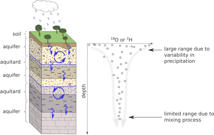
通过多层含水层系统的水转移是难以表征的。本研究探讨了深度水混合的概念模型是否可以外推到一个跨越几十公里、包括多个含水层的水文系统。这些过程使用同位素示踪剂和压力测量监测的组合进行了超过10年的研究。这种方法的目标是更好地理解马达加斯加西南部马哈法利高原复杂而缺乏文献记载的水文系统中的水转移是如何发生的。结果表明同位素随深度变化的平滑性明显,与补给峰的平滑性相关。同位素值在近地表(-6.8 ~ -2.5‰18 O)变化剧烈,在临界深度(20 m左右)稳定在-4.7‰18 O左右。这些结果表明,在含水层系统中,既没有明显的优势补给线,也没有明显的横向混合。如此强烈的地下水同位素随深度变化的平滑效应,很少在大空间尺度上如此清晰地观测到。这些结果提供了与地下水资源评估相关的远程地下水流动系统的信息。结果还表明,马哈法利高原新近系含水层除了向始新世深岩溶渗透外,与其他水资源(河流、古沉积地层)的联系较差。这意味着Ankazomanga盆地的地下水资源是有限的,了解和量化补给对于可持续地下水管理至关重要。
本文章由计算机程序翻译,如有差异,请以英文原文为准。

达加斯加西南部复杂多层水系中的水体混合过程:联合同位素和压力测量方法

达加斯加西南部复杂多层水系中的水体混合过程:联合同位素和压力测量方法
Abstract Water transfers through a multilayered aquifer system are difficult to characterize. This study explores whether the conceptual model of water mixing at depth can be extrapolated over a hydrosystem extended across several tens of kilometers and including multiple aquifer layers. The processes are investigated using a combination of isotope tracers and piezometric monitoring over 10 years. The goal of this approach is to better understand how water transfer occurs throughout a complex and poorly documented hydrosystem of the Mahafaly Plateau in southwestern Madagascar. The results show a clear smoothing of isotopic variability with depth, associated with a smoothing of the recharge peaks. Isotopic values are strongly variable in the near surface (from -6.8 to -2.5‰ 18 O) and stabilize at a critical depth (near 20 m) at around -4.7‰ 18 O. These results indicate high vertical flows through the aquifer system, where there is neither obvious dominant recharge via preferential pathways nor lateral mixing. Such a strong smoothing effect on groundwater isotopic variability with depth has been rarely observed so clearly over a large spatial scale. These results provide information on a remote groundwater flow system at a scale pertinent to groundwater resource assessment. The results also indicate that the Neogene aquifers of the Mahafaly Plateau are poorly connected with other water resources (rivers, old sedimentary formations) except for the percolation of water towards the deep Eocene karst. This means that groundwater resources in the Ankazomanga Basin are limited and that it is essential to understand and quantify recharge for sustainable groundwater management.
求助全文
通过发布文献求助,成功后即可免费获取论文全文。 去求助
来源期刊
Hydrogeology Journal
Hydrogeology Journal 地学-地球科学综合
CiteScore
5.40
自引率
7.10%
发文量
128
审稿时长
6 months
期刊介绍: Hydrogeology Journal was founded in 1992 to foster understanding of hydrogeology; to describe worldwide progress in hydrogeology; and to provide an accessible forum for scientists, researchers, engineers, and practitioners in developing and industrialized countries. Since then, the journal has earned a large worldwide readership. Its peer-reviewed research articles integrate subsurface hydrology and geology with supporting disciplines: geochemistry, geophysics, geomorphology, geobiology, surface-water hydrology, tectonics, numerical modeling, economics, and sociology.
×
引用
GB/T 7714-2015
复制
MLA
复制
APA
复制
导出至
BibTeX EndNote RefMan NoteFirst NoteExpress
×
提示
您的信息不完整,为了账户安全,请先补充。
现在去补充
×
提示
您因"违规操作"
具体请查看互助需知
我知道了
×
提示
确定
请完成安全验证×
copy
已复制链接
快去分享给好友吧!
我知道了
右上角分享
点击右上角分享
0
联系我们:info@booksci.cn Book学术提供免费学术资源搜索服务,方便国内外学者检索中英文文献。致力于提供最便捷和优质的服务体验。 Copyright © 2023 布克学术 All rights reserved.
京ICP备2023020795号-1
ghs 京公网安备 11010802042870号
Book学术文献互助
Book学术文献互助群
群 号:481959085
Book学术官方微信