S Mohanasundaram, K S Kasiviswanathan, C Purnanjali, I Putu Santikayasa, Shilpa Singh
{"title":"利用遥感变量对南亚全球网格化作物产量数据产品和作物水分生产率绘图进行降尺度处理。","authors":"S Mohanasundaram, K S Kasiviswanathan, C Purnanjali, I Putu Santikayasa, Shilpa Singh","doi":"10.1007/s42106-022-00223-2","DOIUrl":null,"url":null,"abstract":"<p><p>Local scale crop yield and crop water productivity information is critical for informed decision making, crop yield forecasting and crop model calibration applications. In this study, we have attempted to downscale coarse resolution primary season rice yield datasets to a local scale of 500 m using a minimum-median downscaling approach. Sixteen mainland countries in south and southeast Asia region were considered as study region to downscale global rice yield datasets for 2000-2015. Four medium resolution remote sensing derived vegetation indices such as Normalised Difference Vegetation Index (NDVI), Enhanced Vegetation Index (EVI), Leaf Area Index (LAI), and Gross Primary Product (GPP) were used to downscale coarse resolution global rice yield datasets. A kharif season district level rice yield data from International Crops Research Institute for the Semi-Arid Tropics (ICRISAT), India was used as a reference dataset to evaluate the downscaled rice yields at the district scale. The proposed downscaling approach performance was satisfactory with a mean absolute error (MAE) range of 0.85-1.2 t/ha which lies in the error range of 10-15% with respect to actual range of reference rice yield datasets. Furthermore, crop water productivity maps at 500 m scale were also developed with the downscaled rice yield and Moderate Resolution Imaging Spectroradiometer (MODIS) Evapotranspiration (ET) data products. Statistical analysis shows that the rice yield and crop water productivity values across different climate zones were statistically significant. Tropical zone-based crop yield and crop water productivity values were showing higher variation when compared to other climate zones with a range of 1-10 t/ha and 1-12.5 kg/m<sup>3</sup>, respectively.</p><p><strong>Supplementary information: </strong>The online version contains supplementary material available at 10.1007/s42106-022-00223-2.</p>","PeriodicalId":54947,"journal":{"name":"International Journal of Plant Production","volume":"17 1","pages":"1-16"},"PeriodicalIF":2.2000,"publicationDate":"2023-01-01","publicationTypes":"Journal Article","fieldsOfStudy":null,"isOpenAccess":false,"openAccessPdf":"https://www.ncbi.nlm.nih.gov/pmc/articles/PMC9648444/pdf/","citationCount":"0","resultStr":"{\"title\":\"Downscaling Global Gridded Crop Yield Data Products and Crop Water Productivity Mapping Using Remote Sensing Derived Variables in the South Asia.\",\"authors\":\"S Mohanasundaram, K S Kasiviswanathan, C Purnanjali, I Putu Santikayasa, Shilpa Singh\",\"doi\":\"10.1007/s42106-022-00223-2\",\"DOIUrl\":null,\"url\":null,\"abstract\":\"<p><p>Local scale crop yield and crop water productivity information is critical for informed decision making, crop yield forecasting and crop model calibration applications. In this study, we have attempted to downscale coarse resolution primary season rice yield datasets to a local scale of 500 m using a minimum-median downscaling approach. Sixteen mainland countries in south and southeast Asia region were considered as study region to downscale global rice yield datasets for 2000-2015. Four medium resolution remote sensing derived vegetation indices such as Normalised Difference Vegetation Index (NDVI), Enhanced Vegetation Index (EVI), Leaf Area Index (LAI), and Gross Primary Product (GPP) were used to downscale coarse resolution global rice yield datasets. A kharif season district level rice yield data from International Crops Research Institute for the Semi-Arid Tropics (ICRISAT), India was used as a reference dataset to evaluate the downscaled rice yields at the district scale. The proposed downscaling approach performance was satisfactory with a mean absolute error (MAE) range of 0.85-1.2 t/ha which lies in the error range of 10-15% with respect to actual range of reference rice yield datasets. Furthermore, crop water productivity maps at 500 m scale were also developed with the downscaled rice yield and Moderate Resolution Imaging Spectroradiometer (MODIS) Evapotranspiration (ET) data products. Statistical analysis shows that the rice yield and crop water productivity values across different climate zones were statistically significant. Tropical zone-based crop yield and crop water productivity values were showing higher variation when compared to other climate zones with a range of 1-10 t/ha and 1-12.5 kg/m<sup>3</sup>, respectively.</p><p><strong>Supplementary information: </strong>The online version contains supplementary material available at 10.1007/s42106-022-00223-2.</p>\",\"PeriodicalId\":54947,\"journal\":{\"name\":\"International Journal of Plant Production\",\"volume\":\"17 1\",\"pages\":\"1-16\"},\"PeriodicalIF\":2.2000,\"publicationDate\":\"2023-01-01\",\"publicationTypes\":\"Journal Article\",\"fieldsOfStudy\":null,\"isOpenAccess\":false,\"openAccessPdf\":\"https://www.ncbi.nlm.nih.gov/pmc/articles/PMC9648444/pdf/\",\"citationCount\":\"0\",\"resultStr\":null,\"platform\":\"Semanticscholar\",\"paperid\":null,\"PeriodicalName\":\"International Journal of Plant Production\",\"FirstCategoryId\":\"97\",\"ListUrlMain\":\"https://doi.org/10.1007/s42106-022-00223-2\",\"RegionNum\":3,\"RegionCategory\":\"农林科学\",\"ArticlePicture\":[],\"TitleCN\":null,\"AbstractTextCN\":null,\"PMCID\":null,\"EPubDate\":\"2022/11/10 0:00:00\",\"PubModel\":\"Epub\",\"JCR\":\"Q2\",\"JCRName\":\"AGRONOMY\",\"Score\":null,\"Total\":0}","platform":"Semanticscholar","paperid":null,"PeriodicalName":"International Journal of Plant Production","FirstCategoryId":"97","ListUrlMain":"https://doi.org/10.1007/s42106-022-00223-2","RegionNum":3,"RegionCategory":"农林科学","ArticlePicture":[],"TitleCN":null,"AbstractTextCN":null,"PMCID":null,"EPubDate":"2022/11/10 0:00:00","PubModel":"Epub","JCR":"Q2","JCRName":"AGRONOMY","Score":null,"Total":0}
Downscaling Global Gridded Crop Yield Data Products and Crop Water Productivity Mapping Using Remote Sensing Derived Variables in the South Asia.
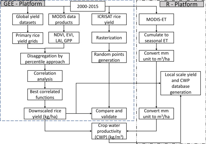
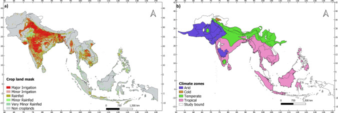
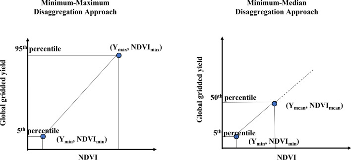
Local scale crop yield and crop water productivity information is critical for informed decision making, crop yield forecasting and crop model calibration applications. In this study, we have attempted to downscale coarse resolution primary season rice yield datasets to a local scale of 500 m using a minimum-median downscaling approach. Sixteen mainland countries in south and southeast Asia region were considered as study region to downscale global rice yield datasets for 2000-2015. Four medium resolution remote sensing derived vegetation indices such as Normalised Difference Vegetation Index (NDVI), Enhanced Vegetation Index (EVI), Leaf Area Index (LAI), and Gross Primary Product (GPP) were used to downscale coarse resolution global rice yield datasets. A kharif season district level rice yield data from International Crops Research Institute for the Semi-Arid Tropics (ICRISAT), India was used as a reference dataset to evaluate the downscaled rice yields at the district scale. The proposed downscaling approach performance was satisfactory with a mean absolute error (MAE) range of 0.85-1.2 t/ha which lies in the error range of 10-15% with respect to actual range of reference rice yield datasets. Furthermore, crop water productivity maps at 500 m scale were also developed with the downscaled rice yield and Moderate Resolution Imaging Spectroradiometer (MODIS) Evapotranspiration (ET) data products. Statistical analysis shows that the rice yield and crop water productivity values across different climate zones were statistically significant. Tropical zone-based crop yield and crop water productivity values were showing higher variation when compared to other climate zones with a range of 1-10 t/ha and 1-12.5 kg/m3, respectively.
Supplementary information: The online version contains supplementary material available at 10.1007/s42106-022-00223-2.
期刊介绍:
IJPP publishes original research papers and review papers related to physiology, ecology and production of field crops and forages at field, farm and landscape level. Preferred topics are: (1) yield gap in cropping systems: estimation, causes and closing measures, (2) ecological intensification of plant production, (3) improvement of water and nutrients management in plant production systems, (4) environmental impact of plant production, (5) climate change and plant production, and (6) responses of plant communities to extreme weather conditions.
Please note that IJPP does not publish papers with a background in genetics and plant breeding, plant molecular biology, plant biotechnology, as well as soil science, meteorology, product process and post-harvest management unless they are strongly related to plant production under field conditions.
Papers based on limited data or of local importance, and results from routine experiments will not normally be considered for publication. Field experiments should include at least two years and/or two environments. Papers on plants other than field crops and forages, and papers based on controlled-environment experiments will not be considered.
 求助内容:
求助内容: 应助结果提醒方式:


