Fangzheng Lyu, Shaohua Wang, Su Yeon Han, Charlie Catlett, Shaowen Wang
{"title":"利用卫星遥感和城市传感器网络数据对城市热岛进行精细预测的集成网络地理信息系统和机器学习框架。","authors":"Fangzheng Lyu, Shaohua Wang, Su Yeon Han, Charlie Catlett, Shaowen Wang","doi":"10.1007/s44212-022-00002-4","DOIUrl":null,"url":null,"abstract":"<p><p>Due to climate change and rapid urbanization, Urban Heat Island (UHI), featuring significantly higher temperature in metropolitan areas than surrounding areas, has caused negative impacts on urban communities. Temporal granularity is often limited in UHI studies based on satellite remote sensing data that typically has multi-day frequency coverage of a particular urban area. This low temporal frequency has restricted the development of models for predicting UHI. To resolve this limitation, this study has developed a cyber-based geographic information science and systems (cyberGIS) framework encompassing multiple machine learning models for predicting UHI with high-frequency urban sensor network data combined with remote sensing data focused on Chicago, Illinois, from 2018 to 2020. Enabled by rapid advances in urban sensor network technologies and high-performance computing, this framework is designed to predict UHI in Chicago with fine spatiotemporal granularity based on environmental data collected with the Array of Things (AoT) urban sensor network and Landsat-8 remote sensing imagery. Our computational experiments revealed that a random forest regression (RFR) model outperforms other models with the prediction accuracy of 0.45 degree Celsius in 2020 and 0.8 degree Celsius in 2018 and 2019 with mean absolute error as the evaluation metric. Humidity, distance to geographic center, and PM<sub>2.5</sub> concentration are identified as important factors contributing to the model performance. Furthermore, we estimate UHI in Chicago with 10-min temporal frequency and 1-km spatial resolution on the hottest day in 2018. It is demonstrated that the RFR model can accurately predict UHI at fine spatiotemporal scales with high-frequency urban sensor network data integrated with satellite remote sensing data.</p>","PeriodicalId":75283,"journal":{"name":"Urban informatics","volume":"1 1","pages":"6"},"PeriodicalIF":0.0000,"publicationDate":"2022-01-01","publicationTypes":"Journal Article","fieldsOfStudy":null,"isOpenAccess":false,"openAccessPdf":"https://www.ncbi.nlm.nih.gov/pmc/articles/PMC9458483/pdf/","citationCount":"9","resultStr":"{\"title\":\"An integrated cyberGIS and machine learning framework for fine-scale prediction of Urban Heat Island using satellite remote sensing and urban sensor network data.\",\"authors\":\"Fangzheng Lyu, Shaohua Wang, Su Yeon Han, Charlie Catlett, Shaowen Wang\",\"doi\":\"10.1007/s44212-022-00002-4\",\"DOIUrl\":null,\"url\":null,\"abstract\":\"<p><p>Due to climate change and rapid urbanization, Urban Heat Island (UHI), featuring significantly higher temperature in metropolitan areas than surrounding areas, has caused negative impacts on urban communities. Temporal granularity is often limited in UHI studies based on satellite remote sensing data that typically has multi-day frequency coverage of a particular urban area. This low temporal frequency has restricted the development of models for predicting UHI. To resolve this limitation, this study has developed a cyber-based geographic information science and systems (cyberGIS) framework encompassing multiple machine learning models for predicting UHI with high-frequency urban sensor network data combined with remote sensing data focused on Chicago, Illinois, from 2018 to 2020. Enabled by rapid advances in urban sensor network technologies and high-performance computing, this framework is designed to predict UHI in Chicago with fine spatiotemporal granularity based on environmental data collected with the Array of Things (AoT) urban sensor network and Landsat-8 remote sensing imagery. Our computational experiments revealed that a random forest regression (RFR) model outperforms other models with the prediction accuracy of 0.45 degree Celsius in 2020 and 0.8 degree Celsius in 2018 and 2019 with mean absolute error as the evaluation metric. Humidity, distance to geographic center, and PM<sub>2.5</sub> concentration are identified as important factors contributing to the model performance. Furthermore, we estimate UHI in Chicago with 10-min temporal frequency and 1-km spatial resolution on the hottest day in 2018. It is demonstrated that the RFR model can accurately predict UHI at fine spatiotemporal scales with high-frequency urban sensor network data integrated with satellite remote sensing data.</p>\",\"PeriodicalId\":75283,\"journal\":{\"name\":\"Urban informatics\",\"volume\":\"1 1\",\"pages\":\"6\"},\"PeriodicalIF\":0.0000,\"publicationDate\":\"2022-01-01\",\"publicationTypes\":\"Journal Article\",\"fieldsOfStudy\":null,\"isOpenAccess\":false,\"openAccessPdf\":\"https://www.ncbi.nlm.nih.gov/pmc/articles/PMC9458483/pdf/\",\"citationCount\":\"9\",\"resultStr\":null,\"platform\":\"Semanticscholar\",\"paperid\":null,\"PeriodicalName\":\"Urban informatics\",\"FirstCategoryId\":\"1085\",\"ListUrlMain\":\"https://doi.org/10.1007/s44212-022-00002-4\",\"RegionNum\":0,\"RegionCategory\":null,\"ArticlePicture\":[],\"TitleCN\":null,\"AbstractTextCN\":null,\"PMCID\":null,\"EPubDate\":\"2022/9/9 0:00:00\",\"PubModel\":\"Epub\",\"JCR\":\"\",\"JCRName\":\"\",\"Score\":null,\"Total\":0}","platform":"Semanticscholar","paperid":null,"PeriodicalName":"Urban informatics","FirstCategoryId":"1085","ListUrlMain":"https://doi.org/10.1007/s44212-022-00002-4","RegionNum":0,"RegionCategory":null,"ArticlePicture":[],"TitleCN":null,"AbstractTextCN":null,"PMCID":null,"EPubDate":"2022/9/9 0:00:00","PubModel":"Epub","JCR":"","JCRName":"","Score":null,"Total":0}
An integrated cyberGIS and machine learning framework for fine-scale prediction of Urban Heat Island using satellite remote sensing and urban sensor network data.
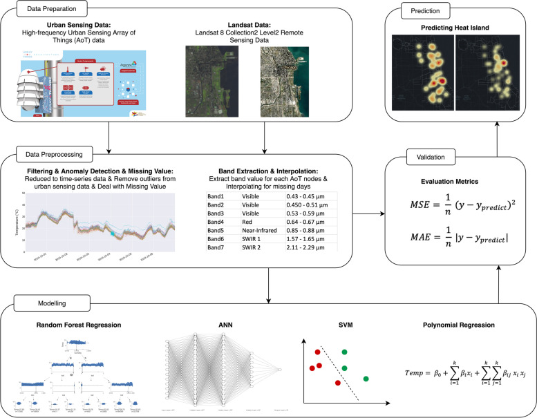
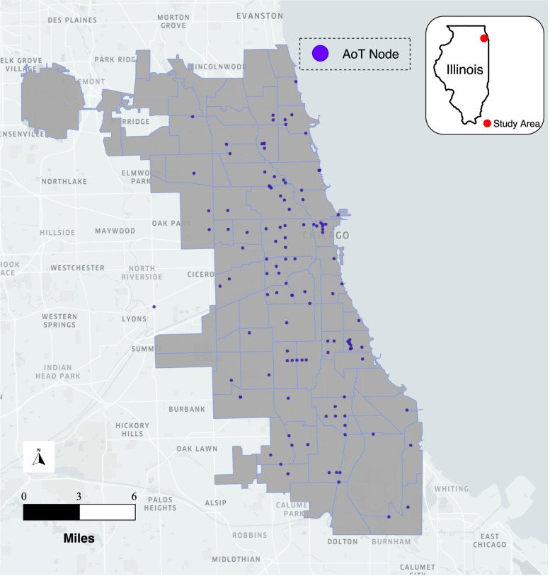
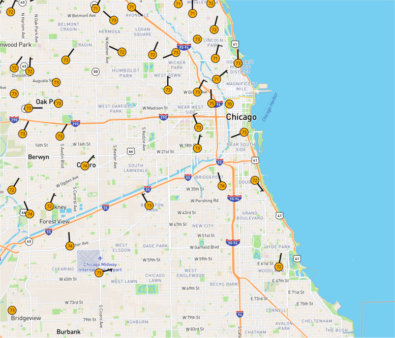
Due to climate change and rapid urbanization, Urban Heat Island (UHI), featuring significantly higher temperature in metropolitan areas than surrounding areas, has caused negative impacts on urban communities. Temporal granularity is often limited in UHI studies based on satellite remote sensing data that typically has multi-day frequency coverage of a particular urban area. This low temporal frequency has restricted the development of models for predicting UHI. To resolve this limitation, this study has developed a cyber-based geographic information science and systems (cyberGIS) framework encompassing multiple machine learning models for predicting UHI with high-frequency urban sensor network data combined with remote sensing data focused on Chicago, Illinois, from 2018 to 2020. Enabled by rapid advances in urban sensor network technologies and high-performance computing, this framework is designed to predict UHI in Chicago with fine spatiotemporal granularity based on environmental data collected with the Array of Things (AoT) urban sensor network and Landsat-8 remote sensing imagery. Our computational experiments revealed that a random forest regression (RFR) model outperforms other models with the prediction accuracy of 0.45 degree Celsius in 2020 and 0.8 degree Celsius in 2018 and 2019 with mean absolute error as the evaluation metric. Humidity, distance to geographic center, and PM2.5 concentration are identified as important factors contributing to the model performance. Furthermore, we estimate UHI in Chicago with 10-min temporal frequency and 1-km spatial resolution on the hottest day in 2018. It is demonstrated that the RFR model can accurately predict UHI at fine spatiotemporal scales with high-frequency urban sensor network data integrated with satellite remote sensing data.

 求助内容:
求助内容: 应助结果提醒方式:


