{"title":"Mobile-based image interpretation and geotagging using artificial intelligence and open-source geospatial technology","authors":"Arati Paul, Sakshi Chauhan, Dibyendu Dutta","doi":"10.1007/s12518-023-00522-x","DOIUrl":null,"url":null,"abstract":"<div><p>Image geotagging is a process where geographic coordinates are attached to an image. Mobile-based geotagging application has many advantages, viz. real-time monitoring, ensuring data authenticity etc. Since an ordinary mobile camera cannot interpret the geotagged images, they are manually analysed later for a specific purpose. Therefore, the human interpreters are to put their time and effort to analyse the images. This becomes difficult when the number of images is more. The heterogeneity of captured images, in terms of intensity, viewing angle etc., limits the application of traditional image processing techniques for automatic image interpretation. Hence, artificial intelligence (AI)–based image processing technique needs to be employed that enables machines to learn from instances and provide assistance in field photo interpretation. In the present work, a smartphone-based application, embedded with enhanced capabilities of AI and geospatial technology, has been developed using open-source technology. The application employs AI to detect certain categories’ semantic objects and automatically generates their details. The mean of detection precision, recall and F1 score are estimated as 0.96, 0.91 and 0.93, respectively. The present work successfully demonstrates the use of open-source technology for AI-enabled geotagging and dissemination of ground information through WebGIS application.</p></div>","PeriodicalId":46286,"journal":{"name":"Applied Geomatics","volume":"15 4","pages":"795 - 805"},"PeriodicalIF":2.3000,"publicationDate":"2023-09-07","publicationTypes":"Journal Article","fieldsOfStudy":null,"isOpenAccess":false,"openAccessPdf":"","citationCount":"0","resultStr":null,"platform":"Semanticscholar","paperid":null,"PeriodicalName":"Applied Geomatics","FirstCategoryId":"1085","ListUrlMain":"https://link.springer.com/article/10.1007/s12518-023-00522-x","RegionNum":0,"RegionCategory":null,"ArticlePicture":[],"TitleCN":null,"AbstractTextCN":null,"PMCID":null,"EPubDate":"","PubModel":"","JCR":"Q2","JCRName":"REMOTE SENSING","Score":null,"Total":0}
引用次数: 0
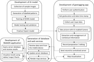
Abstract
Image geotagging is a process where geographic coordinates are attached to an image. Mobile-based geotagging application has many advantages, viz. real-time monitoring, ensuring data authenticity etc. Since an ordinary mobile camera cannot interpret the geotagged images, they are manually analysed later for a specific purpose. Therefore, the human interpreters are to put their time and effort to analyse the images. This becomes difficult when the number of images is more. The heterogeneity of captured images, in terms of intensity, viewing angle etc., limits the application of traditional image processing techniques for automatic image interpretation. Hence, artificial intelligence (AI)–based image processing technique needs to be employed that enables machines to learn from instances and provide assistance in field photo interpretation. In the present work, a smartphone-based application, embedded with enhanced capabilities of AI and geospatial technology, has been developed using open-source technology. The application employs AI to detect certain categories’ semantic objects and automatically generates their details. The mean of detection precision, recall and F1 score are estimated as 0.96, 0.91 and 0.93, respectively. The present work successfully demonstrates the use of open-source technology for AI-enabled geotagging and dissemination of ground information through WebGIS application.
期刊介绍:
Applied Geomatics (AGMJ) is the official journal of SIFET the Italian Society of Photogrammetry and Topography and covers all aspects and information on scientific and technical advances in the geomatics sciences. The Journal publishes innovative contributions in geomatics applications ranging from the integration of instruments, methodologies and technologies and their use in the environmental sciences, engineering and other natural sciences.
The areas of interest include many research fields such as: remote sensing, close range and videometric photogrammetry, image analysis, digital mapping, land and geographic information systems, geographic information science, integrated geodesy, spatial data analysis, heritage recording; network adjustment and numerical processes. Furthermore, Applied Geomatics is open to articles from all areas of deformation measurements and analysis, structural engineering, mechanical engineering and all trends in earth and planetary survey science and space technology. The Journal also contains notices of conferences and international workshops, industry news, and information on new products. It provides a useful forum for professional and academic scientists involved in geomatics science and technology.
Information on Open Research Funding and Support may be found here: https://www.springernature.com/gp/open-research/institutional-agreements

 求助内容:
求助内容: 应助结果提醒方式:


