Real‐time mosaic of multiple fisheye surveillance videos based on geo‐registration and rectification

Jiongli Gao, Jun Wu, Mingyi Huang, Gang Xu
{"title":"Real‐time mosaic of multiple fisheye surveillance videos based on geo‐registration and rectification","authors":"Jiongli Gao, Jun Wu, Mingyi Huang, Gang Xu","doi":"10.1111/phor.12455","DOIUrl":null,"url":null,"abstract":"A distributed fisheye video surveillance system (DFVSS) can monitor a wide area without blind spots, but it is often affected by the viewpoint discontinuity and space inconsistency of multiple videos in the area. This paper proposes a novel real‐time fisheye video mosaic algorithm for wide‐area surveillance. First, by extending the line photogrammetry theory under central projection to spherical projection, a fisheye video geo‐registration model is established and estimated using orthogonal parallel lines on the ground, so that all videos of DFVSS are in the unified reference system to eliminate the space inconsistency between them. Second, by combining the photogrammetry orthorectification technique with thin‐plate spline transformation, a fisheye video rectification model is established to eliminate serious distortion in geo‐registered fisheye videos and align them accurately. Third, the viewport‐dependent video selection strategy and video look‐up table computation technique are adopted to create a high‐resolution panorama from input fisheye videos in real time. A parking lot of about 0.4 km2 monitored by eight fisheye cameras was selected as the test area. The experimental result shows the line re‐projection error in fisheye videos is about 0.5 pixels, and the overall efficiency, including panorama creation and mapping to the ground as texture, is not <30 fps. It indicates that the proposed algorithm can achieve a good balance between the limitation of video transmission bandwidth and the smooth observation requirement of computer equipment for the panorama, which is of great value for the construction and application of DFVSS.","PeriodicalId":22881,"journal":{"name":"The Photogrammetric Record","volume":"1 1","pages":"339 - 373"},"PeriodicalIF":0.0000,"publicationDate":"2023-07-18","publicationTypes":"Journal Article","fieldsOfStudy":null,"isOpenAccess":false,"openAccessPdf":"","citationCount":"0","resultStr":null,"platform":"Semanticscholar","paperid":null,"PeriodicalName":"The Photogrammetric Record","FirstCategoryId":"1085","ListUrlMain":"https://doi.org/10.1111/phor.12455","RegionNum":0,"RegionCategory":null,"ArticlePicture":[],"TitleCN":null,"AbstractTextCN":null,"PMCID":null,"EPubDate":"","PubModel":"","JCR":"","JCRName":"","Score":null,"Total":0}
引用次数: 0

Abstract

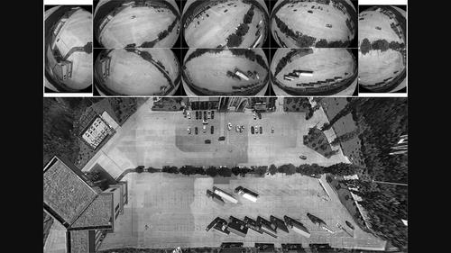
A distributed fisheye video surveillance system (DFVSS) can monitor a wide area without blind spots, but it is often affected by the viewpoint discontinuity and space inconsistency of multiple videos in the area. This paper proposes a novel real‐time fisheye video mosaic algorithm for wide‐area surveillance. First, by extending the line photogrammetry theory under central projection to spherical projection, a fisheye video geo‐registration model is established and estimated using orthogonal parallel lines on the ground, so that all videos of DFVSS are in the unified reference system to eliminate the space inconsistency between them. Second, by combining the photogrammetry orthorectification technique with thin‐plate spline transformation, a fisheye video rectification model is established to eliminate serious distortion in geo‐registered fisheye videos and align them accurately. Third, the viewport‐dependent video selection strategy and video look‐up table computation technique are adopted to create a high‐resolution panorama from input fisheye videos in real time. A parking lot of about 0.4 km2 monitored by eight fisheye cameras was selected as the test area. The experimental result shows the line re‐projection error in fisheye videos is about 0.5 pixels, and the overall efficiency, including panorama creation and mapping to the ground as texture, is not <30 fps. It indicates that the proposed algorithm can achieve a good balance between the limitation of video transmission bandwidth and the smooth observation requirement of computer equipment for the panorama, which is of great value for the construction and application of DFVSS.
Abstract Image

基于地理配准和校正的多鱼眼监控视频实时拼接
分布式鱼眼视频监控系统(DFVSS)可以在无盲点的大范围内进行监控,但经常受到视点不连续和空间不一致的影响。提出了一种用于广域监控的实时鱼眼视频拼接算法。首先,将中心投影下的线摄影测量理论扩展到球面投影,建立鱼眼视频地理配准模型,利用地面上的正交平行线进行估计,使DFVSS所有视频处于统一的参照系中,消除了视频之间的空间不一致;其次,将摄影测量正校正技术与薄板样条变换相结合,建立鱼眼视频校正模型,消除地质配准鱼眼视频严重失真,实现准确对准;第三,采用视口依赖视频选择策略和视频查找表计算技术,从输入的鱼眼视频实时生成高分辨率全景图。选取8台鱼眼摄像机监测的停车场面积约0.4 km2作为试验区。实验结果表明,鱼眼视频的线重投影误差约为0.5像素,整体效率(包括全景创建和映射到地面的纹理)不小于30 fps。结果表明,该算法能够很好地平衡视频传输带宽的限制和计算机设备对全景图像的平滑观测要求,对DFVSS的构建和应用具有重要价值。
本文章由计算机程序翻译,如有差异,请以英文原文为准。
求助全文
约1分钟内获得全文 求助全文
来源期刊
自引率
0.00%
发文量
0
×
引用
GB/T 7714-2015
复制
MLA
复制
APA
复制
导出至
BibTeX EndNote RefMan NoteFirst NoteExpress
×
提示
您的信息不完整,为了账户安全,请先补充。
现在去补充
×
提示
您因"违规操作"
具体请查看互助需知
我知道了
×
提示
确定
请完成安全验证×
copy
已复制链接
快去分享给好友吧!
我知道了
右上角分享
点击右上角分享
0
联系我们:info@booksci.cn Book学术提供免费学术资源搜索服务,方便国内外学者检索中英文文献。致力于提供最便捷和优质的服务体验。 Copyright © 2023 布克学术 All rights reserved.
京ICP备2023020795号-1
ghs 京公网安备 11010802042870号
Book学术文献互助
Book学术文献互助群
群 号:481959085
Book学术官方微信