M. Kirsch, M. Mavroudi, Samuel T. Thiele, S. Lorenz, Laura Tusa, R. Booysen, Erik Herrmann, Ayoub Fatihi, R. Möckel, Thomas Dittrich, R. Gloaguen
{"title":"Underground hyperspectral outcrop scanning for automated mine‐face mapping: The lithium deposit of Zinnwald/Cínovec","authors":"M. Kirsch, M. Mavroudi, Samuel T. Thiele, S. Lorenz, Laura Tusa, R. Booysen, Erik Herrmann, Ayoub Fatihi, R. Möckel, Thomas Dittrich, R. Gloaguen","doi":"10.1111/phor.12457","DOIUrl":null,"url":null,"abstract":"The inherent complexity of underground mining requires highly selective ore extraction and adaptive mine planning. Repeated geological face mapping and reinterpretation throughout mine life is therefore routine in underground mines. Hyperspectral imaging (HSI) has successfully been applied to enhance geological mapping in surface mining environments, but remains a largely unexplored opportunity in underground operations due to challenges associated with illumination, wet surfaces and data corrections. In this study, we propose a workflow that paves the way for the operational use of HSI in active underground mines. In a laboratory set‐up, we evaluated different hyperspectral sensors and lighting set‐ups as well as the effect of surface moisture. We then acquired hyperspectral data in an underground mine of the Zinnwald/Cínovec Sn‐W‐Li greisen‐type deposit in Germany. These data were corrected for illumination effects, back‐projected into three dimensions and then used to map mineral abundance and estimate Li content across the mine face. We validated the results with handheld laser‐induced breakdown spectroscopy. Despite remaining challenges, we hope this study will help establish hyperspectral sensors in the extractive industry as a means to increase the volume and efficiency of raw material supply, advance digitalisation, and reduce the environmental footprint and other risks associated with underground mining.","PeriodicalId":22881,"journal":{"name":"The Photogrammetric Record","volume":"91 1","pages":"408 - 429"},"PeriodicalIF":0.0000,"publicationDate":"2023-08-28","publicationTypes":"Journal Article","fieldsOfStudy":null,"isOpenAccess":false,"openAccessPdf":"","citationCount":"0","resultStr":null,"platform":"Semanticscholar","paperid":null,"PeriodicalName":"The Photogrammetric Record","FirstCategoryId":"1085","ListUrlMain":"https://doi.org/10.1111/phor.12457","RegionNum":0,"RegionCategory":null,"ArticlePicture":[],"TitleCN":null,"AbstractTextCN":null,"PMCID":null,"EPubDate":"","PubModel":"","JCR":"","JCRName":"","Score":null,"Total":0}
引用次数: 0
Abstract
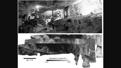
The inherent complexity of underground mining requires highly selective ore extraction and adaptive mine planning. Repeated geological face mapping and reinterpretation throughout mine life is therefore routine in underground mines. Hyperspectral imaging (HSI) has successfully been applied to enhance geological mapping in surface mining environments, but remains a largely unexplored opportunity in underground operations due to challenges associated with illumination, wet surfaces and data corrections. In this study, we propose a workflow that paves the way for the operational use of HSI in active underground mines. In a laboratory set‐up, we evaluated different hyperspectral sensors and lighting set‐ups as well as the effect of surface moisture. We then acquired hyperspectral data in an underground mine of the Zinnwald/Cínovec Sn‐W‐Li greisen‐type deposit in Germany. These data were corrected for illumination effects, back‐projected into three dimensions and then used to map mineral abundance and estimate Li content across the mine face. We validated the results with handheld laser‐induced breakdown spectroscopy. Despite remaining challenges, we hope this study will help establish hyperspectral sensors in the extractive industry as a means to increase the volume and efficiency of raw material supply, advance digitalisation, and reduce the environmental footprint and other risks associated with underground mining.
地下开采固有的复杂性要求高度选择性的矿石开采和适应性的矿山规划。因此,在整个矿山生命周期中,重复的地质面填图和重新解释是地下矿山的常规工作。高光谱成像(HSI)已经成功地应用于地表采矿环境的地质测绘,但由于光照、潮湿表面和数据校正等方面的挑战,在地下作业中,HSI仍然是一个很大的未开发的机会。在这项研究中,我们提出了一个工作流,为在活跃的地下矿山中实际使用HSI铺平了道路。在实验室设置中,我们评估了不同的高光谱传感器和照明设置以及表面湿度的影响。然后,我们在德国Zinnwald/Cínovec Sn - W - Li greisen - type矿床的地下矿山中获得了高光谱数据。这些数据经过光照效果校正,反向投影成三维,然后用于绘制矿产丰度图,并估算整个矿区的锂含量。我们用手持式激光诱导击穿光谱验证了结果。尽管仍然存在挑战,我们希望这项研究将有助于在采掘业建立高光谱传感器,作为增加原材料供应数量和效率、推进数字化、减少环境足迹和与地下采矿相关的其他风险的一种手段。

 求助内容:
求助内容: 应助结果提醒方式:


