J.A. Lara-Hernández , C. Enriquez , J. Zavala-Hidalgo , E. Cuevas , B. van Tussenbroek , A. Uribe-Martínez
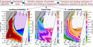
{"title":"Sargassum transport towards Mexican Caribbean shores: Numerical modeling for research and forecasting","authors":"J.A. Lara-Hernández , C. Enriquez , J. Zavala-Hidalgo , E. Cuevas , B. van Tussenbroek , A. Uribe-Martínez","doi":"10.1016/j.jmarsys.2023.103923","DOIUrl":null,"url":null,"abstract":"<div><p>A cost-effective particle-tracking model was implemented to study the transport and landing of sargassum in the Mexican Caribbean. Sensitivity analyses were performed to quantify the change in landing percentages varying some model factors: 1) windage factor, 2) the horizontal distribution of sargassum, 3) monthly variability of currents and winds, 4) sargassum growth, 5) thickness of the transporting ocean layer, 6) wind data source, and 7) ocean data source. The windage factor had the greatest effect on landing estimates: as it increased, the sargassum landing percentage increased by 19%. In second place, differences in the initial horizontal distribution of sargassum caused the landing percentage to change by ∼10%. In third place, the monthly variability of currents and winds changed the landing percentage by 6%. The northern shoreline of Mexican Caribbean (between 20.25°N and 20.75°N) was the most prone to sargassum landings. At the regional scale, this condition is related with a) the shoreline orientation in that region, which more clearly faces the northward flow of the Yucatán Current, and b) the position of Cozumel Island, which acts as an offshore barrier capturing sargassum. Most of landed sargassum in the Mexican Caribbean had floated 0–40 km east and south of Chinchorro Bank, within 18.25°N and 18.75°N (southern Mexican Caribbean), and then spread along the shore. Monitoring, containment, and collection of sargassum east and south of Chinchorro Bank could help predict and mitigate sargassum landings about 5 days in advance.</p></div>","PeriodicalId":50150,"journal":{"name":"Journal of Marine Systems","volume":null,"pages":null},"PeriodicalIF":2.7000,"publicationDate":"2023-08-11","publicationTypes":"Journal Article","fieldsOfStudy":null,"isOpenAccess":false,"openAccessPdf":"","citationCount":"1","resultStr":null,"platform":"Semanticscholar","paperid":null,"PeriodicalName":"Journal of Marine Systems","FirstCategoryId":"89","ListUrlMain":"https://www.sciencedirect.com/science/article/pii/S0924796323000672","RegionNum":3,"RegionCategory":"地球科学","ArticlePicture":[],"TitleCN":null,"AbstractTextCN":null,"PMCID":null,"EPubDate":"","PubModel":"","JCR":"Q2","JCRName":"GEOSCIENCES, MULTIDISCIPLINARY","Score":null,"Total":0}
引用次数: 1
Abstract
A cost-effective particle-tracking model was implemented to study the transport and landing of sargassum in the Mexican Caribbean. Sensitivity analyses were performed to quantify the change in landing percentages varying some model factors: 1) windage factor, 2) the horizontal distribution of sargassum, 3) monthly variability of currents and winds, 4) sargassum growth, 5) thickness of the transporting ocean layer, 6) wind data source, and 7) ocean data source. The windage factor had the greatest effect on landing estimates: as it increased, the sargassum landing percentage increased by 19%. In second place, differences in the initial horizontal distribution of sargassum caused the landing percentage to change by ∼10%. In third place, the monthly variability of currents and winds changed the landing percentage by 6%. The northern shoreline of Mexican Caribbean (between 20.25°N and 20.75°N) was the most prone to sargassum landings. At the regional scale, this condition is related with a) the shoreline orientation in that region, which more clearly faces the northward flow of the Yucatán Current, and b) the position of Cozumel Island, which acts as an offshore barrier capturing sargassum. Most of landed sargassum in the Mexican Caribbean had floated 0–40 km east and south of Chinchorro Bank, within 18.25°N and 18.75°N (southern Mexican Caribbean), and then spread along the shore. Monitoring, containment, and collection of sargassum east and south of Chinchorro Bank could help predict and mitigate sargassum landings about 5 days in advance.
期刊介绍:
The Journal of Marine Systems provides a medium for interdisciplinary exchange between physical, chemical and biological oceanographers and marine geologists. The journal welcomes original research papers and review articles. Preference will be given to interdisciplinary approaches to marine systems.
 求助内容:
求助内容: 应助结果提醒方式:


