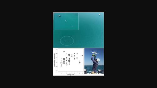
Using Unoccupied Aerial Vehicles to estimate availability and group size error for aerial surveys of coastal dolphins
IF 3.9
2区 环境科学与生态学
Q1 ECOLOGY
引用次数: 3
Abstract
Aerial surveys are frequently used to estimate the abundance of marine mammals, but their accuracy is dependent upon obtaining a measure of the availability of animals to visual detection. Existing methods for characterizing availability have limitations and do not necessarily reflect true availability. Here, we present a method of using small, vessel‐launched, multi‐rotor Unoccupied Aerial Vehicles (UAVs, or drones) to collect video of dolphins to characterize availability and investigate error surrounding group size estimates. We collected over 20 h of aerial video of dive‐surfacing behaviour across 32 encounters with Australian humpback dolphins Sousa sahulensis off north‐western Australia. Mean surfacing and dive periods were 7.85 sec (se = 0.26) and 39.27 sec (se = 1.31) respectively. Dolphin encounters were split into 56 focal follows of consistent group composition to which example approaches to estimating availability were applied. Non‐instantaneous availability estimates, assuming a 7 sec observation window, ranged between 0.22 and 0.88, with a mean availability of 0.46 (CV = 0.34). Availability tended to increase with increasing group size. We found a downward bias in group size estimation, with true group size typically one individual more than would have been estimated by a human observer during a standard aerial survey. The variability of availability estimates between focal follows highlights the importance of sampling across a variety of group sizes, compositions and environmental conditions. Through data re‐sampling exercises, we explored the influence of sample size on availability estimates and their precision, with results providing an indication of target sample sizes to minimize bias in future research. We show that UAVs can provide an effective and relatively inexpensive method of characterizing dolphin availability with several advantages over existing approaches. The example estimates obtained for humpback dolphins are within the range of values obtained for other shallow‐water, small cetaceans, and will directly inform a government‐run program of aerial surveys in the region.

使用无人驾驶飞行器估计沿海海豚航空调查的可用性和群体大小误差
航空调查经常用于估计海洋哺乳动物的丰度,但其准确性取决于能否获得可供视觉检测的动物。现有的表征可用性的方法有局限性,不一定反映真实的可用性。在这里,我们提出了一种使用小型船载多旋翼无人驾驶飞行器(UAV或无人机)收集海豚视频的方法,以表征可用性并调查群体规模估计的误差。我们收集了超过20小时的空中视频,记录了在澳大利亚西北部与澳大利亚座头鲸Sousa sahulensis相遇的32次潜水行为。平均浮出水面和潜水时间分别为7.85秒(se=0.26)和39.27秒(se=1.31)。海豚遭遇战被分为56个焦点小组,小组组成一致,应用了评估可用性的示例方法。假设观察窗口为7秒,非瞬时可用性估计值介于0.22和0.88之间,平均可用性为0.46(CV=0.34)。可用性往往随着团队规模的增加而增加。我们发现群体规模估计存在向下的偏差,真实的群体规模通常比人类观测者在标准空中调查中估计的多出一个人。焦点关注之间可用性估计的可变性突出了在各种群体规模、组成和环境条件下采样的重要性。通过数据重新采样,我们探讨了样本量对可用性估计及其精度的影响,结果提供了目标样本量的指示,以最大限度地减少未来研究中的偏差。我们表明,无人机可以提供一种有效且相对便宜的方法来表征海豚的可用性,与现有方法相比有几个优势。座头鲸的示例估计值在其他浅水小型鲸目动物的值范围内,并将直接为该地区政府运营的航空调查项目提供信息。
本文章由计算机程序翻译,如有差异,请以英文原文为准。
求助全文
约1分钟内获得全文
求助全文
来源期刊

Remote Sensing in Ecology and Conservation
Earth and Planetary Sciences-Computers in Earth Sciences
CiteScore
9.80
自引率
5.50%
发文量
69
审稿时长
18 weeks
期刊介绍:
emote Sensing in Ecology and Conservation provides a forum for rapid, peer-reviewed publication of novel, multidisciplinary research at the interface between remote sensing science and ecology and conservation. The journal prioritizes findings that advance the scientific basis of ecology and conservation, promoting the development of remote-sensing based methods relevant to the management of land use and biological systems at all levels, from populations and species to ecosystems and biomes. The journal defines remote sensing in its broadest sense, including data acquisition by hand-held and fixed ground-based sensors, such as camera traps and acoustic recorders, and sensors on airplanes and satellites. The intended journal’s audience includes ecologists, conservation scientists, policy makers, managers of terrestrial and aquatic systems, remote sensing scientists, and students.
Remote Sensing in Ecology and Conservation is a fully open access journal from Wiley and the Zoological Society of London. Remote sensing has enormous potential as to provide information on the state of, and pressures on, biological diversity and ecosystem services, at multiple spatial and temporal scales. This new publication provides a forum for multidisciplinary research in remote sensing science, ecological research and conservation science.
 求助内容:
求助内容: 应助结果提醒方式:


