Comparison of 3D structural metrics on oyster reefs using unoccupied aircraft photogrammetry and terrestrial LiDAR across a tidal elevation gradient
IF 4.3
2区 环境科学与生态学
Q1 ECOLOGY
引用次数: 4
Abstract
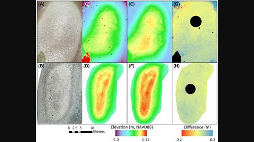
Physical structures generated from ecosystem engineers can have a cascade of impacts on the ecological community and the surrounding landscape. The Eastern oyster Crassostrea virginica can form extensive intertidal reefs, whose three‐dimensional structures provide ecosystem services like nursery and foraging habitat for fishes and invertebrates and shoreline stabilization. Measurements of the structural properties of these reefs provide opportunities to quantitatively assess associated services. There is a growing variety of tools available for measuring three‐dimensional (3D) properties of intertidal habitats, including two remote sensing methods that capture 3D structural metrics in a number of environments. We surveyed reefs using a terrestrial laser scanner (TLS, LiDAR) and imagery from unoccupied aircraft systems (UAS, or drones) processed through Structure from Motion photogrammetry. Comparisons of digital elevation models from repetitive flights over an oyster reef to checkpoints yielded mean horizontal and vertical root mean square errors (RMSE) of −0.54 ± 0.47 cm and 0.97 ± 1.0 cm (Mean ± SD), respectively, indicating high accuracy among UAS surveys. Compared to TLS products, point cloud densities from UAS‐derived products were more consistent across the reef elevation gradient and much denser overall except in the low reef zone, which was proximal to most of the TLS scan locations. Comparisons of structural metrics between UAS and TLS showed similarities in metrics like profile and planform curvatures, yet indicated UAS surveys produced higher values of surface complexity and slope. Results indicate that UAS photogrammetry can produce robust oyster reef structural metrics that can be highly useful in oyster conservation and restoration.

利用无人飞机摄影测量和陆地激光雷达在潮汐高程梯度上对牡蛎礁的三维结构度量进行比较
由生态系统工程师产生的物理结构可以对生态群落和周围景观产生一连串的影响。东方牡蛎(Crassostrea virginica)可以形成广泛的潮间带礁,其三维结构为鱼类和无脊椎动物提供了苗圃和觅食栖息地,并为海岸线稳定提供了生态系统服务。对这些珊瑚礁结构特性的测量为定量评估相关服务提供了机会。有越来越多的工具可用于测量潮间带栖息地的三维(3D)特性,包括在许多环境中捕获三维结构度量的两种遥感方法。我们使用陆地激光扫描仪(TLS, LiDAR)和通过运动摄影测量处理的无人飞机系统(UAS或无人机)的图像来调查珊瑚礁。将重复飞越牡蛎礁的数字高程模型与检查站进行比较,平均水平和垂直均方根误差(RMSE)分别为- 0.54±0.47 cm和0.97±1.0 cm (mean±SD),表明UAS调查的精度很高。与TLS产品相比,来自UAS衍生产品的点云密度在整个珊瑚礁高程梯度上更加一致,除了靠近大多数TLS扫描位置的低珊瑚礁区域外,总体密度更高。通过比较UAS和TLS的结构指标,可以发现在剖面和平台曲率等指标上存在相似之处,但也表明UAS测量的表面复杂性和坡度值更高。结果表明,UAS摄影测量可以产生稳健的牡蛎礁结构指标,对牡蛎保护和恢复具有重要意义。
本文章由计算机程序翻译,如有差异,请以英文原文为准。
求助全文
约1分钟内获得全文
求助全文
来源期刊

Remote Sensing in Ecology and Conservation
Earth and Planetary Sciences-Computers in Earth Sciences
CiteScore
9.80
自引率
5.50%
发文量
69
审稿时长
18 weeks
期刊介绍:
emote Sensing in Ecology and Conservation provides a forum for rapid, peer-reviewed publication of novel, multidisciplinary research at the interface between remote sensing science and ecology and conservation. The journal prioritizes findings that advance the scientific basis of ecology and conservation, promoting the development of remote-sensing based methods relevant to the management of land use and biological systems at all levels, from populations and species to ecosystems and biomes. The journal defines remote sensing in its broadest sense, including data acquisition by hand-held and fixed ground-based sensors, such as camera traps and acoustic recorders, and sensors on airplanes and satellites. The intended journal’s audience includes ecologists, conservation scientists, policy makers, managers of terrestrial and aquatic systems, remote sensing scientists, and students.
Remote Sensing in Ecology and Conservation is a fully open access journal from Wiley and the Zoological Society of London. Remote sensing has enormous potential as to provide information on the state of, and pressures on, biological diversity and ecosystem services, at multiple spatial and temporal scales. This new publication provides a forum for multidisciplinary research in remote sensing science, ecological research and conservation science.
 求助内容:
求助内容: 应助结果提醒方式:


