Prospects for monitoring bird migration along the East Asian‐Australasian Flyway using weather radar
IF 3.9
2区 环境科学与生态学
Q1 ECOLOGY
引用次数: 0
Abstract
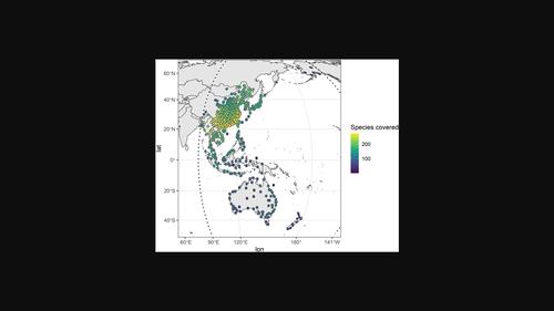
Each year, billions of birds migrate across the globe, and interpretation of weather radar signals is increasingly being used to document the spatial and temporal migration patterns in Europe and America. Such approaches are yet to be applied in the East Asian‐Australasian Flyway (EAAF), one of the most species‐rich and threatened flyways in the world. Logistical challenges limit direct on‐ground monitoring of migratory birds in many parts of the EAAF, resulting in knowledge gaps on population status and site use that limit evidence‐based conservation planning. Weather radar data have great potential for achieving comprehensive migratory bird monitoring along the EAAF. In this study, we discuss the feasibility and challenges of using weather radar to complement on‐ground bird migration surveys in the flyway. We summarize the location, capacity and data availability of weather radars across EAAF countries, as well as the spatial coverage of the radars with respect to migrants' geographic distribution and migration hotspots along the flyway, with an exemplar analysis of biological movement patterns extracted from Chinese weather radars. There are more than 430 weather radars in EAAF countries, covering on average half of bird species' passage and non‐breeding distributions, as well as 70% of internationally important sites for migratory shorebirds. We conclude that the weather radar network could be a powerful resource for monitoring bird movements over the full annual cycle throughout much of the EAAF, providing estimates of migration traffic rates, site use, and long‐term population trends, especially in remote and less‐surveyed regions. Analyses of weather radar data would complement existing ornithological surveys and help understand the past and present status of the avian community in a highly threatened flyway.

利用气象雷达监测东亚-澳大拉西亚候鸟迁徙的前景
每年,数十亿的鸟类在全球范围内迁徙,天气雷达信号的解释越来越多地用于记录欧洲和美洲的时空迁徙模式。东亚-澳大拉西亚飞道(EAAF)是世界上物种最丰富、最受威胁的飞道之一,但这些方法尚未应用于该飞道。后勤方面的挑战限制了对EAAF许多地区候鸟的直接地面监测,导致关于种群状况和场地使用的知识差距,从而限制了基于证据的保护规划。气象雷达数据对实现东亚高原候鸟综合监测具有很大潜力。在本研究中,我们讨论了利用气象雷达补充飞行路线上地面鸟类迁徙调查的可行性和挑战。我们总结了东亚地区气象雷达的位置、容量和数据可用性,以及雷达对候鸟地理分布和迁徙热点的空间覆盖,并以中国气象雷达提取的生物运动模式为例进行了分析。EAAF国家有430多个气象雷达,平均覆盖了一半的鸟类过境和非繁殖分布,以及70%的国际重要候鸟栖息地。我们得出的结论是,天气雷达网络可以作为一个强大的资源,在整个EAAF的整个年周期内监测鸟类的运动,提供迁徙交通率、场地使用和长期人口趋势的估计,特别是在偏远和较少调查的地区。气象雷达数据的分析将补充现有的鸟类学调查,并有助于了解高度受威胁飞行路线上鸟类群落的过去和现在的状况。
本文章由计算机程序翻译,如有差异,请以英文原文为准。
求助全文
约1分钟内获得全文
求助全文
来源期刊

Remote Sensing in Ecology and Conservation
Earth and Planetary Sciences-Computers in Earth Sciences
CiteScore
9.80
自引率
5.50%
发文量
69
审稿时长
18 weeks
期刊介绍:
emote Sensing in Ecology and Conservation provides a forum for rapid, peer-reviewed publication of novel, multidisciplinary research at the interface between remote sensing science and ecology and conservation. The journal prioritizes findings that advance the scientific basis of ecology and conservation, promoting the development of remote-sensing based methods relevant to the management of land use and biological systems at all levels, from populations and species to ecosystems and biomes. The journal defines remote sensing in its broadest sense, including data acquisition by hand-held and fixed ground-based sensors, such as camera traps and acoustic recorders, and sensors on airplanes and satellites. The intended journal’s audience includes ecologists, conservation scientists, policy makers, managers of terrestrial and aquatic systems, remote sensing scientists, and students.
Remote Sensing in Ecology and Conservation is a fully open access journal from Wiley and the Zoological Society of London. Remote sensing has enormous potential as to provide information on the state of, and pressures on, biological diversity and ecosystem services, at multiple spatial and temporal scales. This new publication provides a forum for multidisciplinary research in remote sensing science, ecological research and conservation science.
 求助内容:
求助内容: 应助结果提醒方式:


