Katharina T. Streuff, Colm Ó Cofaigh, Paul Wintersteller
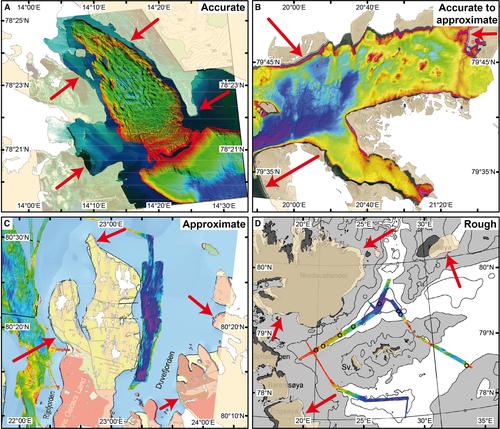
{"title":"GlaciDat – a GIS database of submarine glacial landforms and sediments in the Arctic","authors":"Katharina T. Streuff, Colm Ó Cofaigh, Paul Wintersteller","doi":"10.1111/bor.12577","DOIUrl":null,"url":null,"abstract":"<p>A digital database for submarine glacial landforms and sediments formed in the Arctic during and since the Last Glacial Maximum was created in order to facilitate and underpin new research on palaeo-ice sheets and tidewater glacier dynamics. The glacimarine database (GlaciDat) documents and standardises evidence of previous glacial activity as visible on the contemporary seafloor of fjords and continental shelves around Svalbard, Greenland, Alaska, northern Russia and north of 66°30′N in Canada and Norway. An extensive literature search was conducted to create GlaciDat, which compiles nearly 60 000 individual submarine landforms, more than 1000 sediment cores and 232 radiocarbon dates. Glacial landforms included are cross-shelf troughs, trough-mouth fans, grounding-zone wedges, lateral moraines, overridden moraines, (mega-scale) glacial lineations, drumlins, crag-and-tails, medial moraines, terminal moraines, debris-flow lobes (including glacier-contact fans), recessional moraines, De Geer moraines, crevasse-fill ridges, eskers, hill-hole pairs, crescentic scours, and submarine channels. They were digitised as point, line and polygon features alongside a list of their individual characteristics. Sediment core locations are attributed with a description of the sampled lithofacies and sedimentation rates where available. Landforms and sediments have been standardised according to predefined nomenclatures to make the glacial evidence as consistent as possible. Marine radiocarbon dates were included when thought to be relevant for constraining the timing of large-scale palaeo-ice dynamics. Outlines of bathymetric data sets, which have previously been used for glacial geomorphological mapping, were also included to give an overview of already investigated research areas. GlaciDat is available for download (https://doi.pangaea.de/10.1594/PANGAEA.937782) and will aid researchers in the reconstruction of past ice dynamics and the interpretation of Arctic glacial landform–sediment assemblages. Moreover, as well as providing a comprehensive bibliography on Arctic glacial geomorphological and sedimentological research, it is intended to serve as a basis for future modelling of Arctic glacier and ice-sheet dynamics.</p>","PeriodicalId":9184,"journal":{"name":"Boreas","volume":"51 3","pages":"517-531"},"PeriodicalIF":2.9000,"publicationDate":"2022-01-06","publicationTypes":"Journal Article","fieldsOfStudy":null,"isOpenAccess":false,"openAccessPdf":"https://onlinelibrary.wiley.com/doi/epdf/10.1111/bor.12577","citationCount":"8","resultStr":null,"platform":"Semanticscholar","paperid":null,"PeriodicalName":"Boreas","FirstCategoryId":"89","ListUrlMain":"https://onlinelibrary.wiley.com/doi/10.1111/bor.12577","RegionNum":3,"RegionCategory":"地球科学","ArticlePicture":[],"TitleCN":null,"AbstractTextCN":null,"PMCID":null,"EPubDate":"","PubModel":"","JCR":"Q2","JCRName":"GEOGRAPHY, PHYSICAL","Score":null,"Total":0}
引用次数: 8
Abstract
A digital database for submarine glacial landforms and sediments formed in the Arctic during and since the Last Glacial Maximum was created in order to facilitate and underpin new research on palaeo-ice sheets and tidewater glacier dynamics. The glacimarine database (GlaciDat) documents and standardises evidence of previous glacial activity as visible on the contemporary seafloor of fjords and continental shelves around Svalbard, Greenland, Alaska, northern Russia and north of 66°30′N in Canada and Norway. An extensive literature search was conducted to create GlaciDat, which compiles nearly 60 000 individual submarine landforms, more than 1000 sediment cores and 232 radiocarbon dates. Glacial landforms included are cross-shelf troughs, trough-mouth fans, grounding-zone wedges, lateral moraines, overridden moraines, (mega-scale) glacial lineations, drumlins, crag-and-tails, medial moraines, terminal moraines, debris-flow lobes (including glacier-contact fans), recessional moraines, De Geer moraines, crevasse-fill ridges, eskers, hill-hole pairs, crescentic scours, and submarine channels. They were digitised as point, line and polygon features alongside a list of their individual characteristics. Sediment core locations are attributed with a description of the sampled lithofacies and sedimentation rates where available. Landforms and sediments have been standardised according to predefined nomenclatures to make the glacial evidence as consistent as possible. Marine radiocarbon dates were included when thought to be relevant for constraining the timing of large-scale palaeo-ice dynamics. Outlines of bathymetric data sets, which have previously been used for glacial geomorphological mapping, were also included to give an overview of already investigated research areas. GlaciDat is available for download (https://doi.pangaea.de/10.1594/PANGAEA.937782) and will aid researchers in the reconstruction of past ice dynamics and the interpretation of Arctic glacial landform–sediment assemblages. Moreover, as well as providing a comprehensive bibliography on Arctic glacial geomorphological and sedimentological research, it is intended to serve as a basis for future modelling of Arctic glacier and ice-sheet dynamics.
期刊介绍:
Boreas has been published since 1972. Articles of wide international interest from all branches of Quaternary research are published. Biological as well as non-biological aspects of the Quaternary environment, in both glaciated and non-glaciated areas, are dealt with: Climate, shore displacement, glacial features, landforms, sediments, organisms and their habitat, and stratigraphical and chronological relationships.
Anticipated international interest, at least within a continent or a considerable part of it, is a main criterion for the acceptance of papers. Besides articles, short items like discussion contributions and book reviews are published.
 求助内容:
求助内容: 应助结果提醒方式:


