Challenges and solutions for automated avian recognition in aerial imagery
IF 3.9
2区 环境科学与生态学
Q1 ECOLOGY
引用次数: 2
Abstract
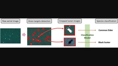
Remote aerial sensing provides a non‐invasive, large geographical‐scale technology for avian monitoring, but the manual processing of images limits its development and applications. Artificial Intelligence (AI) methods can be used to mitigate this manual image processing requirement. The implementation of AI methods, however, has several challenges: (1) imbalanced (i.e., long‐tailed) data distribution, (2) annotation uncertainty in categorization, and (3) dataset discrepancies across different study sites. Here we use aerial imagery data of waterbirds around Cape Cod and Lake Michigan in the United States to examine how these challenges limit avian recognition performance. We review existing solutions and demonstrate as use cases how methods like Label Distribution Aware Marginal Loss with Deferred Re‐Weighting, hierarchical classification, and FixMatch address the three challenges. We also present a new approach to tackle the annotation uncertainty challenge using a Soft‐fine Pseudo‐Label methodology. Finally, we aim with this paper to increase awareness in the ecological remote sensing community of these challenges and bridge the gap between ecological applications and state‐of‐the‐art computer science, thereby opening new doors to future research.

航空图像中鸟类自动识别的挑战和解决方案
航空遥感为鸟类监测提供了一种非侵入性、大地理尺度的技术,但人工处理图像限制了其发展和应用。可以使用人工智能(AI)方法来减轻这种手动图像处理要求。然而,人工智能方法的实施面临着几个挑战:(1)数据分布不平衡(即长尾),(2)分类中的注释不确定性,以及(3)不同研究地点的数据集差异。在这里,我们使用美国科德角和密歇根湖周围水鸟的航空图像数据来研究这些挑战如何限制鸟类识别性能。我们回顾了现有的解决方案,并作为用例演示了标签分布感知边际损失和延迟重新加权、分层分类和FixMatch等方法如何解决这三个挑战。我们还提出了一种使用软精细伪标签方法来解决注释不确定性挑战的新方法。最后,本文旨在提高生态遥感界对这些挑战的认识,弥合生态应用与最先进的计算机科学之间的差距,从而为未来的研究打开新的大门。
本文章由计算机程序翻译,如有差异,请以英文原文为准。
求助全文
约1分钟内获得全文
求助全文
来源期刊

Remote Sensing in Ecology and Conservation
Earth and Planetary Sciences-Computers in Earth Sciences
CiteScore
9.80
自引率
5.50%
发文量
69
审稿时长
18 weeks
期刊介绍:
emote Sensing in Ecology and Conservation provides a forum for rapid, peer-reviewed publication of novel, multidisciplinary research at the interface between remote sensing science and ecology and conservation. The journal prioritizes findings that advance the scientific basis of ecology and conservation, promoting the development of remote-sensing based methods relevant to the management of land use and biological systems at all levels, from populations and species to ecosystems and biomes. The journal defines remote sensing in its broadest sense, including data acquisition by hand-held and fixed ground-based sensors, such as camera traps and acoustic recorders, and sensors on airplanes and satellites. The intended journal’s audience includes ecologists, conservation scientists, policy makers, managers of terrestrial and aquatic systems, remote sensing scientists, and students.
Remote Sensing in Ecology and Conservation is a fully open access journal from Wiley and the Zoological Society of London. Remote sensing has enormous potential as to provide information on the state of, and pressures on, biological diversity and ecosystem services, at multiple spatial and temporal scales. This new publication provides a forum for multidisciplinary research in remote sensing science, ecological research and conservation science.
 求助内容:
求助内容: 应助结果提醒方式:


