Characterizing bedforms in shallow seas as an integrative predictor of seafloor stability and the occurrence of macrozoobenthic species
IF 3.9
2区 环境科学与生态学
Q1 ECOLOGY
引用次数: 1
Abstract
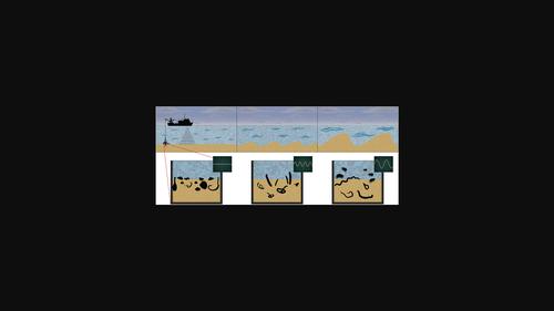
In soft‐bottom marine ecosystems, bedform variation is induced by wind‐ and tidal‐driven hydrodynamics. The resulting megaripples, sand waves and sandbanks form a spatially and temporally heterogeneous seafloor landscape. The strong physical forces imposed by the migration of these bedforms are important determinants for the occurrence of different macrozoobenthic species. Quantifying the effect of these forces can help in differentiating natural‐ and anthropogenically induced physical stressors. However, large‐scale mapping of seabed morphology at high resolution using multibeam echosounder is challenging, costly and time‐consuming, especially in shallow seas, prohibiting wide swaths. Instead, their bathymetry is typically studied using single‐beam transects that are interpolated to bathymetric grids with a relatively coarse resolution (20 m). However, this leaves out information on smaller scale (<20 m) bedforms that can be ecologically relevant. In the Dutch Wadden sea, a shallow tidal system, we characterized bedform variation at high resolution using single‐beam data for the first time. We calculated a 2‐D Terrain Ruggedness Index (TRI) at sub‐meter resolution along the single‐beam transects and interpolated the results to a full 3‐D grid. We then validated the result by relating TRI to independently modeled hydrodynamic parameters and to the distribution of macrozoobenthic species. We found that TRI successfully integrates the variation of tidal‐driven bed shear stress and wave‐driven orbital velocity. In addition, we found TRI to be a good predictor of the occurrence of macrozoobenthic species. The inferred small‐scale bedforms provide valuable information for separating the relative importance of natural dynamics versus anthropogenic disturbances such as dredging and bottom trawling activities. We discuss that by repurposing already available single‐beam data in this way, bedforms can be characterized at high resolution without the need for additional equipment or mapping campaigns, yielding novel input to decision‐making on marine management and conservation.

表征浅海河床作为海底稳定性和大型底栖动物物种发生的综合预测因子
在软底海洋生态系统中,床型变化是由风和潮汐驱动的流体动力学引起的。由此产生的巨大涟漪、沙波和沙洲形成了空间和时间上的异质海底景观。这些床型迁移所施加的强大物理力是不同大型底栖动物物种出现的重要决定因素。量化这些力量的影响有助于区分自然和人类诱发的身体压力源。然而,使用多波束回声测深仪以高分辨率对海床形态进行大规模测绘具有挑战性、成本高昂且耗时,尤其是在浅海,禁止大片海域。相反,他们的测深通常使用单波束样条进行研究,这些样条被插值到具有相对粗略分辨率的测深网格中(20 m) 。然而,这忽略了较小规模的信息(<20 m) 可能与生态相关的床型。在荷兰瓦德登海(一个浅水潮汐系统),我们首次使用单波束数据以高分辨率表征了床型变化。我们沿着单光束样带计算了亚米分辨率的二维地形坚固性指数(TRI),并将结果插值到完整的三维网格中。然后,我们通过将TRI与独立建模的流体动力学参数和大型底栖动物物种的分布联系起来,验证了这一结果。我们发现TRI成功地整合了潮汐驱动床剪切应力和波浪驱动轨道速度的变化。此外,我们发现TRI是大型底栖动物物种发生的一个很好的预测因子。推断出的小尺度床型为区分自然动力学与人为干扰(如疏浚和底拖网捕鱼活动)的相对重要性提供了有价值的信息。我们讨论了通过以这种方式重新利用现有的单波束数据,可以在不需要额外设备或测绘活动的情况下以高分辨率对海床进行表征,从而为海洋管理和保护的决策提供新的输入。
本文章由计算机程序翻译,如有差异,请以英文原文为准。
求助全文
约1分钟内获得全文
求助全文
来源期刊

Remote Sensing in Ecology and Conservation
Earth and Planetary Sciences-Computers in Earth Sciences
CiteScore
9.80
自引率
5.50%
发文量
69
审稿时长
18 weeks
期刊介绍:
emote Sensing in Ecology and Conservation provides a forum for rapid, peer-reviewed publication of novel, multidisciplinary research at the interface between remote sensing science and ecology and conservation. The journal prioritizes findings that advance the scientific basis of ecology and conservation, promoting the development of remote-sensing based methods relevant to the management of land use and biological systems at all levels, from populations and species to ecosystems and biomes. The journal defines remote sensing in its broadest sense, including data acquisition by hand-held and fixed ground-based sensors, such as camera traps and acoustic recorders, and sensors on airplanes and satellites. The intended journal’s audience includes ecologists, conservation scientists, policy makers, managers of terrestrial and aquatic systems, remote sensing scientists, and students.
Remote Sensing in Ecology and Conservation is a fully open access journal from Wiley and the Zoological Society of London. Remote sensing has enormous potential as to provide information on the state of, and pressures on, biological diversity and ecosystem services, at multiple spatial and temporal scales. This new publication provides a forum for multidisciplinary research in remote sensing science, ecological research and conservation science.
 求助内容:
求助内容: 应助结果提醒方式:


