Observed and modelled tidal bar sedimentology reveals preservation bias against mud in estuarine stratigraphy

IF 1.9 3区 地球科学 Q1 GEOLOGY
Lisanne Braat, Harm Jan Pierik, Wout M. van Dijk, Wietse I. van de Lageweg, Muriel Z. M. Brückner, Bas van der Meulen, Maarten G. Kleinhans
{"title":"Observed and modelled tidal bar sedimentology reveals preservation bias against mud in estuarine stratigraphy","authors":"Lisanne Braat, Harm Jan Pierik, Wout M. van Dijk, Wietse I. van de Lageweg, Muriel Z. M. Brückner, Bas van der Meulen, Maarten G. Kleinhans","doi":"10.1002/dep2.190","DOIUrl":null,"url":null,"abstract":"Mud plays a pivotal role in estuarine ecology and morphology. However, field data on the lateral and vertical depositional record of mud are rare. Furthermore, numerical morphodynamic models often ignore mud due to long computational times and simplifications of mixed depositional processes. This study aims to understand the spatial distribution, formative conditions and preservation of mud deposits in the intertidal zone of bars in high‐energy sand‐dominated estuaries, and to elucidate the effects of mud on morphology, ecology and stratigraphic architecture. To meet these objectives, field data (historic bathymetry, bio‐morphological maps and sediment cores of the shoal of Walsoorden, Western Scheldt estuary, the Netherlands) were combined with complementary hydro‐morphodynamic numerical modelling (Delft3D). Based on the field observations, two types of mud deposits were distinguished: (1) mudflat deposits, which are thick (>10 cm) mud beds at the surface associated with high elevations and low accumulation rates; and (2) mud drapes, which are thin (millimetre to centimetre) buried laminae that form and preserve at a wide range of elevations and energy conditions. Model results show that deposition on mudflats occurs just after high‐tide slack water in areas shielded from high flood velocities, suggesting that mud accumulation is mostly controlled by elevation, flow velocity and flow direction. Mud accumulation increases shoal elevation, sometimes to supratidal levels. This reduces flow over the shoal, which in turn reduces chute channel formation, stabilises bar morphology and decreases local tidal prism. These effects further promote mud deposition and vegetation settling. Although observations show that mud cover at the surface is relatively high (20%–40% of the intertidal area), mud constitutes only a small percentage of the total estuary volume (ca 5%) revealing that only a small fraction is preserved in the stratigraphy. Due to this mismatch between surface and subsurface expression of mud, interpretations of estuarine stratigraphy risk underestimating the influence of mud at the surface on morphodynamics and habitats.","PeriodicalId":54144,"journal":{"name":"Depositional Record","volume":"9 2","pages":"380-402"},"PeriodicalIF":1.9000,"publicationDate":"2022-04-07","publicationTypes":"Journal Article","fieldsOfStudy":null,"isOpenAccess":false,"openAccessPdf":"https://onlinelibrary.wiley.com/doi/epdf/10.1002/dep2.190","citationCount":"1","resultStr":null,"platform":"Semanticscholar","paperid":null,"PeriodicalName":"Depositional Record","FirstCategoryId":"89","ListUrlMain":"https://onlinelibrary.wiley.com/doi/10.1002/dep2.190","RegionNum":3,"RegionCategory":"地球科学","ArticlePicture":[],"TitleCN":null,"AbstractTextCN":null,"PMCID":null,"EPubDate":"","PubModel":"","JCR":"Q1","JCRName":"GEOLOGY","Score":null,"Total":0}
引用次数: 1

Abstract

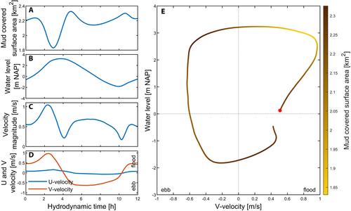
Mud plays a pivotal role in estuarine ecology and morphology. However, field data on the lateral and vertical depositional record of mud are rare. Furthermore, numerical morphodynamic models often ignore mud due to long computational times and simplifications of mixed depositional processes. This study aims to understand the spatial distribution, formative conditions and preservation of mud deposits in the intertidal zone of bars in high‐energy sand‐dominated estuaries, and to elucidate the effects of mud on morphology, ecology and stratigraphic architecture. To meet these objectives, field data (historic bathymetry, bio‐morphological maps and sediment cores of the shoal of Walsoorden, Western Scheldt estuary, the Netherlands) were combined with complementary hydro‐morphodynamic numerical modelling (Delft3D). Based on the field observations, two types of mud deposits were distinguished: (1) mudflat deposits, which are thick (>10 cm) mud beds at the surface associated with high elevations and low accumulation rates; and (2) mud drapes, which are thin (millimetre to centimetre) buried laminae that form and preserve at a wide range of elevations and energy conditions. Model results show that deposition on mudflats occurs just after high‐tide slack water in areas shielded from high flood velocities, suggesting that mud accumulation is mostly controlled by elevation, flow velocity and flow direction. Mud accumulation increases shoal elevation, sometimes to supratidal levels. This reduces flow over the shoal, which in turn reduces chute channel formation, stabilises bar morphology and decreases local tidal prism. These effects further promote mud deposition and vegetation settling. Although observations show that mud cover at the surface is relatively high (20%–40% of the intertidal area), mud constitutes only a small percentage of the total estuary volume (ca 5%) revealing that only a small fraction is preserved in the stratigraphy. Due to this mismatch between surface and subsurface expression of mud, interpretations of estuarine stratigraphy risk underestimating the influence of mud at the surface on morphodynamics and habitats.
Abstract Image

观测和建模的潮坝沉积学揭示了河口地层学中对泥浆的保存偏见
淤泥在河口生态和形态中起着举足轻重的作用。然而,关于泥浆横向和垂直沉积记录的现场数据很少。此外,由于计算时间长和混合沉积过程的简化,数值形态动力学模型经常忽略泥浆。本研究旨在了解高能沙占主导地位的河口潮间带沙坝泥沉积物的空间分布、形成条件和保存情况,并阐明泥对形态、生态和地层结构的影响。为了实现这些目标,将现场数据(荷兰西舍尔德河口Walsoorden浅滩的历史测深、生物形态图和沉积物岩心)与补充的水文形态动力学数值建模(Delft3D)相结合。根据现场观测,区分了两种类型的泥浆沉积:(1)泥滩沉积,即与高海拔和低堆积率相关的地表厚(>10cm)泥浆床;以及(2)泥帘,这是一种薄的(毫米到厘米)埋藏薄层,在各种海拔和能量条件下形成并保存。模型结果表明,在高洪速屏蔽区,泥滩上的沉积发生在高潮松弛水之后,这表明泥浆堆积主要受高程、流速和流向控制。淤泥堆积增加了浅滩高程,有时甚至达到潮上水位。这减少了浅滩上的流量,进而减少了斜槽的形成,稳定了沙洲形态,并减少了局部潮汐棱镜。这些效应进一步促进了泥浆沉积和植被沉降。尽管观测结果表明,表层的泥浆覆盖率相对较高(潮间带面积的20%-40%),但泥浆仅占河口总体积的一小部分(约5%),这表明地层中只保留了一小部分。由于地表和地下泥浆表达之间的不匹配,河口地层学的解释可能低估了地表泥浆对形态动力学和栖息地的影响。
本文章由计算机程序翻译,如有差异,请以英文原文为准。
求助全文
约1分钟内获得全文 求助全文
来源期刊
CiteScore
4.10
自引率
16.70%
发文量
42
审稿时长
16 weeks
×
引用
GB/T 7714-2015
复制
MLA
复制
APA
复制
导出至
BibTeX EndNote RefMan NoteFirst NoteExpress
×
提示
您的信息不完整,为了账户安全,请先补充。
现在去补充
×
提示
您因"违规操作"
具体请查看互助需知
我知道了
×
提示
确定
请完成安全验证×
copy
已复制链接
快去分享给好友吧!
我知道了
右上角分享
点击右上角分享
0
联系我们:info@booksci.cn Book学术提供免费学术资源搜索服务,方便国内外学者检索中英文文献。致力于提供最便捷和优质的服务体验。 Copyright © 2023 布克学术 All rights reserved.
京ICP备2023020795号-1
ghs 京公网安备 11010802042870号
Book学术文献互助
Book学术文献互助群
群 号:481959085
Book学术官方微信