Geoelectric Interpretation of the Magnetic Monitoring Data in the Southwest Part of Baikal
Abstract—
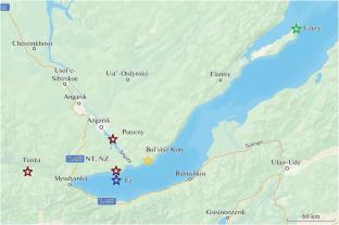
The results of the long-term gradient magnetic measurements performed in the southwest part of Baikal as supplementing the experiment on deep-water monitoring of the electric field vertical component, can be applied to study the deep geoelectric section. Baikal cannot be approximated by a two-dimensional model in the region under study. Therefore, a three-dimensional geoelectric model of the lake and adjacent territories was constructed based on the existing geological and geophysical data. However, these data are insufficient for the region where our observations are carried out. Refinement of the section upper part based on the magnetic field gradients on long bases has been performed using the neural network inversion method. Then, proceeding from the obtained basic model, alternative models were developed, which reflect the known hypotheses about the structure of the deep part of the Baikal rift section: mantle diapir and asthenospheric upwelling. The phase differences between the base-averaged field gradient and the field itself at the base site, as well as the phase differences on the ends of this base, as the most noise-proof gradient functions, are calculated for them. Based on comparison of the experimental and model frequency curves, it is concluded that the mantle diapir model fits best the experimental data, at least, in the southwest part of the Baikal rift zone.
| 公司名称 | 产品信息 | 采购帮参考价格 |
|---|
 求助内容:
求助内容: 应助结果提醒方式:


