Jérémie Bihin, Florence De Longueville, Catherine Linard
{"title":"Spatial accessibility to health facilities in Sub-Saharan Africa: comparing existing models with survey-based perceived accessibility.","authors":"Jérémie Bihin, Florence De Longueville, Catherine Linard","doi":"10.1186/s12942-022-00318-z","DOIUrl":null,"url":null,"abstract":"<p><strong>Background: </strong>Mapping geographical accessibility to health services is essential to improve access to public health in sub-Saharan Africa. Different methods exist to estimate geographical accessibility, but little is known about the ability of these methods to represent the experienced accessibility of the population, and about the added-value of sophisticated and data-demanding methods over simpler ones. Here we compare the most commonly used methods to survey-based perceived accessibility in different geographical settings.</p><p><strong>Methods: </strong>Modelled accessibility maps are computed for 12 selected sub-Saharan African countries using four methods: Euclidean distance, cost-distance considering walking and motorized speed, and Kernel density. All methods are based on open and large-scale datasets to allow replication. Correlation coefficients are computed between the four modelled accessibility indexes and the perceived accessibility index extracted from Demographic and Health Surveys (DHS), and compared across different socio-geographical contexts (rural and urban, population with or without access to motorized transports, per country).</p><p><strong>Results: </strong>Our analysis suggests that, at medium spatial resolution and using globally-consistent input datasets, the use of sophisticated and data-demanding methods is difficult to justify as their added value over a simple Euclidian distance method is not clear. We also highlight that all modelled accessibilities are better correlated with perceived accessibility in rural than urban contexts and for population who do not have access to motorized transportation.</p><p><strong>Conclusions: </strong>This paper should guide researchers in the public health domain for knowing strengths and limits of different methods to evaluate disparities in health services accessibility. We suggest that using cost-distance accessibility maps over Euclidean distance is not always relevant, especially when based on low resolution and/or non-exhaustive geographical datasets, which is often the case in low- and middle-income countries.</p>","PeriodicalId":48739,"journal":{"name":"International Journal of Health Geographics","volume":" ","pages":"18"},"PeriodicalIF":3.0000,"publicationDate":"2022-11-12","publicationTypes":"Journal Article","fieldsOfStudy":null,"isOpenAccess":false,"openAccessPdf":"https://www.ncbi.nlm.nih.gov/pmc/articles/PMC9652128/pdf/","citationCount":"0","resultStr":null,"platform":"Semanticscholar","paperid":null,"PeriodicalName":"International Journal of Health Geographics","FirstCategoryId":"3","ListUrlMain":"https://doi.org/10.1186/s12942-022-00318-z","RegionNum":2,"RegionCategory":"医学","ArticlePicture":[],"TitleCN":null,"AbstractTextCN":null,"PMCID":null,"EPubDate":"","PubModel":"","JCR":"Q2","JCRName":"PUBLIC, ENVIRONMENTAL & OCCUPATIONAL HEALTH","Score":null,"Total":0}
引用次数: 0
Abstract
Background: Mapping geographical accessibility to health services is essential to improve access to public health in sub-Saharan Africa. Different methods exist to estimate geographical accessibility, but little is known about the ability of these methods to represent the experienced accessibility of the population, and about the added-value of sophisticated and data-demanding methods over simpler ones. Here we compare the most commonly used methods to survey-based perceived accessibility in different geographical settings.
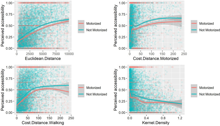
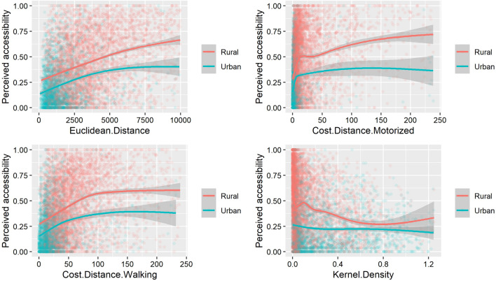
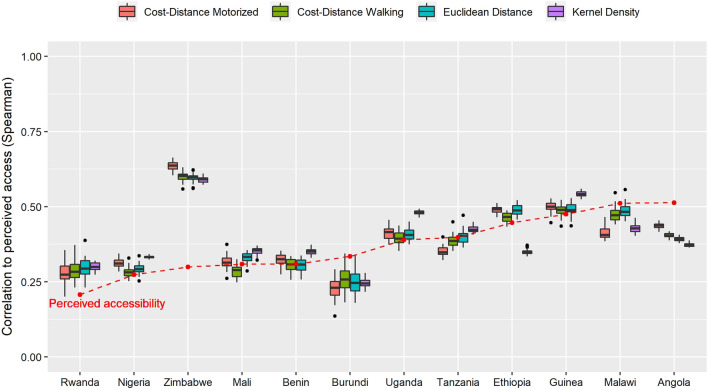
Methods: Modelled accessibility maps are computed for 12 selected sub-Saharan African countries using four methods: Euclidean distance, cost-distance considering walking and motorized speed, and Kernel density. All methods are based on open and large-scale datasets to allow replication. Correlation coefficients are computed between the four modelled accessibility indexes and the perceived accessibility index extracted from Demographic and Health Surveys (DHS), and compared across different socio-geographical contexts (rural and urban, population with or without access to motorized transports, per country).
Results: Our analysis suggests that, at medium spatial resolution and using globally-consistent input datasets, the use of sophisticated and data-demanding methods is difficult to justify as their added value over a simple Euclidian distance method is not clear. We also highlight that all modelled accessibilities are better correlated with perceived accessibility in rural than urban contexts and for population who do not have access to motorized transportation.
Conclusions: This paper should guide researchers in the public health domain for knowing strengths and limits of different methods to evaluate disparities in health services accessibility. We suggest that using cost-distance accessibility maps over Euclidean distance is not always relevant, especially when based on low resolution and/or non-exhaustive geographical datasets, which is often the case in low- and middle-income countries.
期刊介绍:
A leader among the field, International Journal of Health Geographics is an interdisciplinary, open access journal publishing internationally significant studies of geospatial information systems and science applications in health and healthcare. With an exceptional author satisfaction rate and a quick time to first decision, the journal caters to readers across an array of healthcare disciplines globally.
International Journal of Health Geographics welcomes novel studies in the health and healthcare context spanning from spatial data infrastructure and Web geospatial interoperability research, to research into real-time Geographic Information Systems (GIS)-enabled surveillance services, remote sensing applications, spatial epidemiology, spatio-temporal statistics, internet GIS and cyberspace mapping, participatory GIS and citizen sensing, geospatial big data, healthy smart cities and regions, and geospatial Internet of Things and blockchain.
 求助内容:
求助内容: 应助结果提醒方式:


