{"title":"Improving the local climate zone classification with building height, imperviousness, and machine learning for urban models.","authors":"Kwun Yip Fung, Zong-Liang Yang, Dev Niyogi","doi":"10.1007/s43762-022-00046-x","DOIUrl":null,"url":null,"abstract":"<p><p>The Local Climate Zone (LCZ) classification is already widely used in urban heat island and other climate studies. The current classification method does not incorporate crucial urban auxiliary GIS data on building height and imperviousness that could significantly improve urban-type LCZ classification utility as well as accuracy. This study utilized a hybrid GIS- and remote sensing imagery-based framework to systematically compare and evaluate different machine and deep learning methods. The Convolution Neural Network (CNN) classifier outperforms in terms of accuracy, but it requires multi-pixel input, which reduces the output's spatial resolution and creates a tradeoff between accuracy and spatial resolution. The Random Forest (RF) classifier performs best among the single-pixel classifiers. This study also shows that incorporating building height dataset improves the accuracy of the high- and mid-rise classes in the RF classifiers, whereas an imperviousness dataset improves the low-rise classes. The single-pass forward permutation test reveals that both auxiliary datasets dominate the classification accuracy in the RF classifier, while near-infrared and thermal infrared are the dominating features in the CNN classifier. These findings show that the conventional LCZ classification framework used in the World Urban Database and Access Portal Tools (WUDAPT) can be improved by adopting building height and imperviousness information. This framework can be easily applied to different cities to generate LCZ maps for urban models.</p>","PeriodicalId":72667,"journal":{"name":"Computational urban science","volume":" ","pages":"16"},"PeriodicalIF":3.2000,"publicationDate":"2022-01-01","publicationTypes":"Journal Article","fieldsOfStudy":null,"isOpenAccess":false,"openAccessPdf":"https://www.ncbi.nlm.nih.gov/pmc/articles/PMC9206637/pdf/","citationCount":"5","resultStr":null,"platform":"Semanticscholar","paperid":null,"PeriodicalName":"Computational urban science","FirstCategoryId":"1085","ListUrlMain":"https://doi.org/10.1007/s43762-022-00046-x","RegionNum":0,"RegionCategory":null,"ArticlePicture":[],"TitleCN":null,"AbstractTextCN":null,"PMCID":null,"EPubDate":"2022/6/18 0:00:00","PubModel":"Epub","JCR":"Q2","JCRName":"COMPUTER SCIENCE, INTERDISCIPLINARY APPLICATIONS","Score":null,"Total":0}
引用次数: 5
Abstract
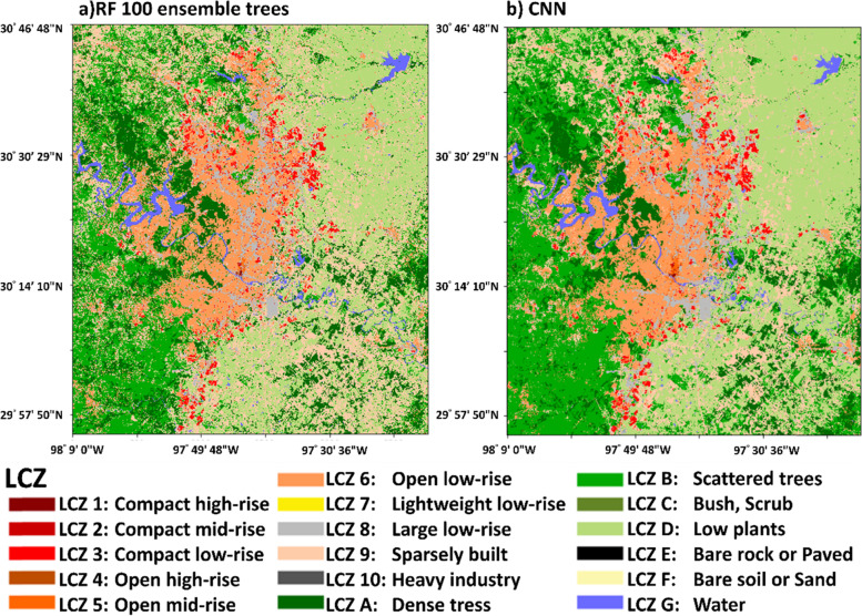
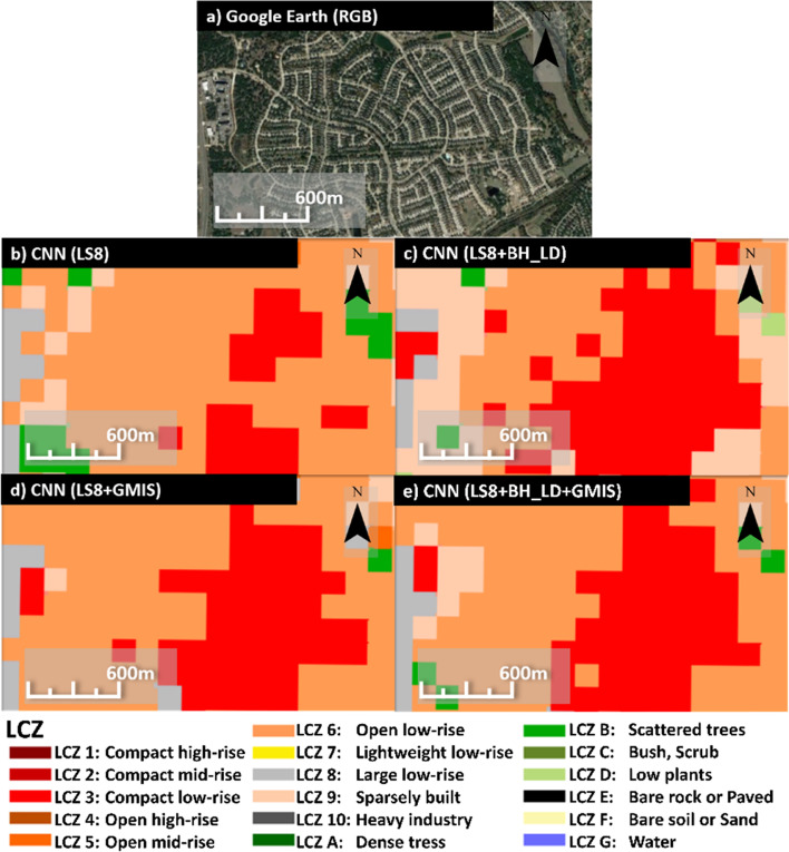
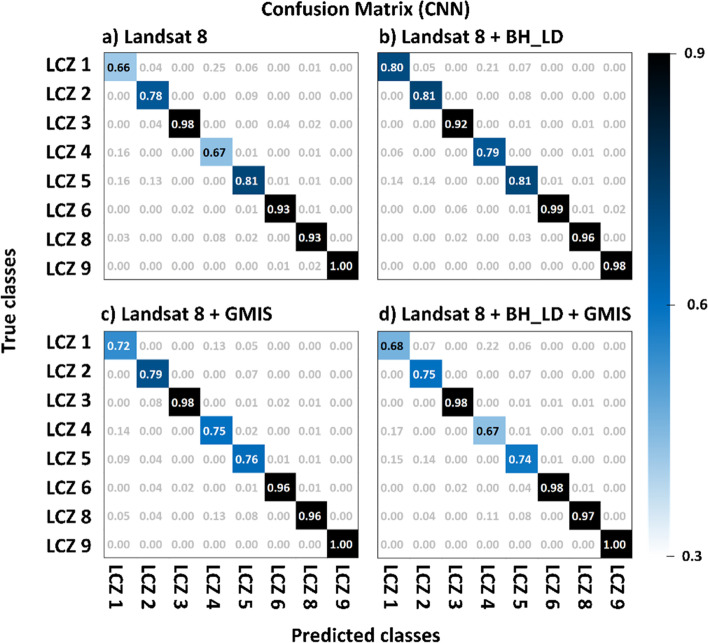
The Local Climate Zone (LCZ) classification is already widely used in urban heat island and other climate studies. The current classification method does not incorporate crucial urban auxiliary GIS data on building height and imperviousness that could significantly improve urban-type LCZ classification utility as well as accuracy. This study utilized a hybrid GIS- and remote sensing imagery-based framework to systematically compare and evaluate different machine and deep learning methods. The Convolution Neural Network (CNN) classifier outperforms in terms of accuracy, but it requires multi-pixel input, which reduces the output's spatial resolution and creates a tradeoff between accuracy and spatial resolution. The Random Forest (RF) classifier performs best among the single-pixel classifiers. This study also shows that incorporating building height dataset improves the accuracy of the high- and mid-rise classes in the RF classifiers, whereas an imperviousness dataset improves the low-rise classes. The single-pass forward permutation test reveals that both auxiliary datasets dominate the classification accuracy in the RF classifier, while near-infrared and thermal infrared are the dominating features in the CNN classifier. These findings show that the conventional LCZ classification framework used in the World Urban Database and Access Portal Tools (WUDAPT) can be improved by adopting building height and imperviousness information. This framework can be easily applied to different cities to generate LCZ maps for urban models.

 求助内容:
求助内容: 应助结果提醒方式:


