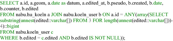
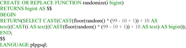
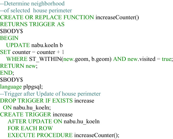
Correction to: Development of a Web GIS for small-scale detection and analysis of COVID-19 (SARS-CoV-2) cases based on volunteered geographic information for the city of Cologne, Germany, in July/August 2020.
IF 3
2区 医学
Q2 PUBLIC, ENVIRONMENTAL & OCCUPATIONAL HEALTH
引用次数: 0
更正:根据2020年7月/ 8月德国科隆市自愿提供的地理信息,开发用于小规模检测和分析COVID-19 (SARS-CoV-2)病例的Web GIS。
本文章由计算机程序翻译,如有差异,请以英文原文为准。
求助全文
约1分钟内获得全文
求助全文
来源期刊
International Journal of Health Geographics
PUBLIC, ENVIRONMENTAL & OCCUPATIONAL HEALTH -
CiteScore
10.20
自引率
2.00%
发文量
17
审稿时长
12 weeks
期刊介绍:
A leader among the field, International Journal of Health Geographics is an interdisciplinary, open access journal publishing internationally significant studies of geospatial information systems and science applications in health and healthcare. With an exceptional author satisfaction rate and a quick time to first decision, the journal caters to readers across an array of healthcare disciplines globally.
International Journal of Health Geographics welcomes novel studies in the health and healthcare context spanning from spatial data infrastructure and Web geospatial interoperability research, to research into real-time Geographic Information Systems (GIS)-enabled surveillance services, remote sensing applications, spatial epidemiology, spatio-temporal statistics, internet GIS and cyberspace mapping, participatory GIS and citizen sensing, geospatial big data, healthy smart cities and regions, and geospatial Internet of Things and blockchain.
 求助内容:
求助内容: 应助结果提醒方式:


